|
gm. Elbląg, pow. elbląski, woj. warmińsko - mazurskie
Until 1945 Ellerwald Zweite Trift TK (Endersch, Schrőtter), Buttermilchstrifvol.

In the Teutonic Knight period, the area of the present-day villages of Adamowo, Kazimierzowo, Janowo, Władysławowo, Helenowo was a wetland, which after the completion of the Kanał Jagielloński in 1495 gradually turned into meadows. They were in possession of Stare Miasto (Old Town). The development of the meadows began in 1563 with the construction of 4 causeways; they divided the area into adjacent plots, which reflected the ownership structure of Stare Miasto in Elbląg. Four hundred thirty five plots were allocated, which corresponded to each tenement house in the town. In order to develop the area, the burghers invited Dutch colonists. The Mennonites who lived in the area belonged to the Ellerwald-Elbing community. In 1776, the following Mennonite surnames were recorded as residents of the Ellerwald villages: Barg, von Bergen, Block, Brand, Brandy, Dircksen, Dick, Sens, Essau, von Riesen, Guenther, Harm, Hiebert, Isaac, Jantzen, Kieler, Kroacker, Loewen, Martens, Neufeldt, Penner, Rempel, Sawatsky, Thiessen, Thimm, Toews, Weis, Wieb, Wiebe, Wiele, Wiens, and Wilmp. In 1921, the area was inhabited by 736 Mennonites. In 1820, Adamów had 201 residents of whom 57 were Mennonites. At the beginning of the 20th century, the village had 491 ha and 236 residents. Village layout - linear village located on terpy The cultural landscape is disappearing. In 1986, out of 41 homesteads only 10-12 still had historical buildings; currently, there are only 5 homesteads with buildings, which include 4 relics of Dutch homesteads and 3 wooden buildings. The village has been severely transformed by the establishment of a state farm with livestock buildings and a housing development. A field layout, a network of drainage canals, relics of homesteads on terpy, and fragments of rows of willows along the canals and roads have survived.
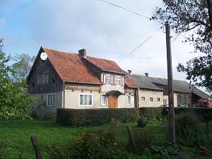
 No. 5 is a house from a Dutch homestead of the longitudinal
type. It is situated on the northern side of the road and faces it with
its ridge. The house was erected at the beginning of the 20th century. It
is a wooden house with a plastered log structure and a wooden pointing
sill. The house has a queen post - collar tie roof structure reinforced
with an angle strut, and a two-bay layout with uneven bays and the square,
large room in the southwestern corner. It has a black kitchen located in
the large rooms bay and an L-shaped, bipartite hallway, which separates
the residential and farming sections. The location of windows in walls
have been partially changed. No. 5 is a house from a Dutch homestead of the longitudinal
type. It is situated on the northern side of the road and faces it with
its ridge. The house was erected at the beginning of the 20th century. It
is a wooden house with a plastered log structure and a wooden pointing
sill. The house has a queen post - collar tie roof structure reinforced
with an angle strut, and a two-bay layout with uneven bays and the square,
large room in the southwestern corner. It has a black kitchen located in
the large rooms bay and an L-shaped, bipartite hallway, which separates
the residential and farming sections. The location of windows in walls
have been partially changed.
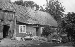
 No. 6 is a Dutch homestead of the
longitudinal type located on the northern side of the road, facing it with
the ridge. The house was erected between 1840 and 1850. It belonged to the
Jetzlaw family until 1945. It is a corner-notched log building with quoins
boarded with planks that imitate Tuscan pilaster. The building has a stone
foundation, a queen post - purlin roof structure, a two-bay layout with
uneven bays, a square-like large room located in the southwestern
corner. It has a centrally located black kitchen and a bipartite,
originally C-shaped hallway, which separates the residential and farming
sections. The hallway has 4 doors leading to a cowshed, stairs, and a
utility room. The gable elevation has 3 axes, a two-level gable with 4
axes at the bottom, two quarter circular skylights, and a semicircular
skylight above. The frontal elevation has 5 axes and an entrance located
in the 2nd axis from the north. The cowshed has 1.5 stories; it was made
of bricks and wood at the beginning of the 20th century. The barn has been
demolished. No. 6 is a Dutch homestead of the
longitudinal type located on the northern side of the road, facing it with
the ridge. The house was erected between 1840 and 1850. It belonged to the
Jetzlaw family until 1945. It is a corner-notched log building with quoins
boarded with planks that imitate Tuscan pilaster. The building has a stone
foundation, a queen post - purlin roof structure, a two-bay layout with
uneven bays, a square-like large room located in the southwestern
corner. It has a centrally located black kitchen and a bipartite,
originally C-shaped hallway, which separates the residential and farming
sections. The hallway has 4 doors leading to a cowshed, stairs, and a
utility room. The gable elevation has 3 axes, a two-level gable with 4
axes at the bottom, two quarter circular skylights, and a semicircular
skylight above. The frontal elevation has 5 axes and an entrance located
in the 2nd axis from the north. The cowshed has 1.5 stories; it was made
of bricks and wood at the beginning of the 20th century. The barn has been
demolished.
Kerstan, s. 199 - 209; ML, t. I, s. 548 - 550; Piątkowski, Lipińska, t. III, poz. 58; AG, BF
|

 No. 5 is a house from a Dutch homestead of the longitudinal
type. It is situated on the northern side of the road and faces it with
its ridge. The house was erected at the beginning of the 20th century. It
is a wooden house with a plastered log structure and a wooden pointing
sill. The house has a queen post - collar tie roof structure reinforced
with an angle strut, and a two-bay layout with uneven bays and the square,
large room in the southwestern corner. It has a black kitchen located in
the large rooms bay and an L-shaped, bipartite hallway, which separates
the residential and farming sections. The location of windows in walls
have been partially changed.
 No. 6 is a Dutch homestead of the
longitudinal type located on the northern side of the road, facing it with
the ridge. The house was erected between 1840 and 1850. It belonged to the
Jetzlaw family until 1945. It is a corner-notched log building with quoins
boarded with planks that imitate Tuscan pilaster. The building has a stone
foundation, a queen post - purlin roof structure, a two-bay layout with
uneven bays, a square-like large room located in the southwestern
corner. It has a centrally located black kitchen and a bipartite,
originally C-shaped hallway, which separates the residential and farming
sections. The hallway has 4 doors leading to a cowshed, stairs, and a
utility room. The gable elevation has 3 axes, a two-level gable with 4
axes at the bottom, two quarter circular skylights, and a semicircular
skylight above. The frontal elevation has 5 axes and an entrance located
in the 2nd axis from the north. The cowshed has 1.5 stories; it was made
of bricks and wood at the beginning of the 20th century. The barn has been
demolished.