|
gm. Markusy, pow. elbląski, woj. warmińsko - mazurskie
Until 1945 Sorgenort TK (Gotha, Endersch, Schrőtter)
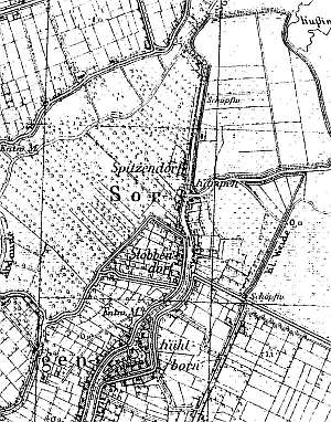
The village was founded in 1676 by Dutch settlers. Until 1945, the village had .... homesteads - mainly of Dutch origin. In addition to a residential and farming building, the former island had a colony with ... small houses. In 1820, the village had 162 residents, including 3 Mennonites and 240 residents in 1885. Village layout - flood bank linear village located on the left (western) bank of the Dzierzgoń river; the majority of the buildings are located below the water level. Currently, the buildings stretch starting ca. 200 m to the south of the bridge (for 1.5 km), mostly on the left side of the road running on the flood bank The village of Stankowo is located on the eastern bank of the river. Currently, there are 11 homesteads with 10 houses, 12 cowsheds, 5 connected barns, and 2 buildings of the pumping station on the northern side of the road. The village has 9 Dutch homesteads of the longitudinal type, mostly located along the flood bank. Four homesteads date from the end of the 18th century, the rest, from the 19th century. Three houses and the pumping stations were completed in 1930s. The old Mennonite cemetery located on a terpa in the western section of the village has been completely destroyed and has several fragments of gravestones. The field layout with polders and draining canals is easily detectable. The original vegetation has partially survived; it mainly includes willows growing in traditional sites: along canals, roads, on fields, and in borders of old fields. A short row of ashes has survived in the southern section.
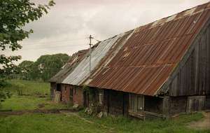
 No. 10 is a Dutch homestead of the longitudinal type and
comprises a house, a cowshed, and a barn. It dates from mid 19th century
and is parallel to the road. The house has a plastered corner-notched log
structure with quoins covered by boards imitating pilaster. A rebuilt
masonry cowshed is plastered and has asbestos tile roofing. The barn has a
half-timbered vertically boarded structure and asbestos tile
roofing. No. 10 is a Dutch homestead of the longitudinal type and
comprises a house, a cowshed, and a barn. It dates from mid 19th century
and is parallel to the road. The house has a plastered corner-notched log
structure with quoins covered by boards imitating pilaster. A rebuilt
masonry cowshed is plastered and has asbestos tile roofing. The barn has a
half-timbered vertically boarded structure and asbestos tile
roofing.
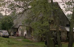
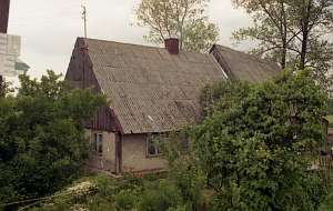
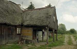 No. 11 is a Dutch homestead of the longitudinal type and
includes a house, a cowshed, and a barn. It is parallel to the road. It is
an arcaded house from the end of the 18th century. Originally, it had a
plastered half-timbered structure, but currently it is made of brick. The
interior has been transformed. The arcade has a double pitched roof with
vertically boarded gable and 7 wooden posts reinforced with angle braces.
The building has a thatched roof (reeds). The cowshed has a half-timbered,
boarded walls and a thatched roof. The half-timbered barn is vertically
boarded and covered by a thatched roof. No. 11 is a Dutch homestead of the longitudinal type and
includes a house, a cowshed, and a barn. It is parallel to the road. It is
an arcaded house from the end of the 18th century. Originally, it had a
plastered half-timbered structure, but currently it is made of brick. The
interior has been transformed. The arcade has a double pitched roof with
vertically boarded gable and 7 wooden posts reinforced with angle braces.
The building has a thatched roof (reeds). The cowshed has a half-timbered,
boarded walls and a thatched roof. The half-timbered barn is vertically
boarded and covered by a thatched roof.
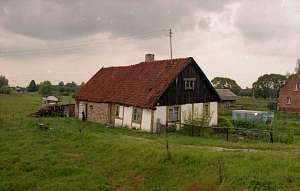 No. 12 is a Dutch
homestead of the longitudinal type and includes a house and a cowshed. It
dates from the end of the 18th century and is parallel to the road. The
house has a half-timbered plastered structure, a vertically boarded gable,
and a double pitched roof covered by pantiles. No. 12 is a Dutch
homestead of the longitudinal type and includes a house and a cowshed. It
dates from the end of the 18th century and is parallel to the road. The
house has a half-timbered plastered structure, a vertically boarded gable,
and a double pitched roof covered by pantiles.
 No. 13 is a Dutch
homestead of the longitudinal type and comprises a house, a masonry
cowshed, and a half-timbered barn with a partially thatched and partially
sheet metal roof. It dates from the end of the 18th century and the turn
of the 19th and 20th centuries. The house has a corner-notched log
structure with quoins covered with boards and a vertically boarded
gable. No. 13 is a Dutch
homestead of the longitudinal type and comprises a house, a masonry
cowshed, and a half-timbered barn with a partially thatched and partially
sheet metal roof. It dates from the end of the 18th century and the turn
of the 19th and 20th centuries. The house has a corner-notched log
structure with quoins covered with boards and a vertically boarded
gable.
No. 16 is a Dutch homestead of the longitudinal type and
includes a house and a cowshed. It dates from the end of the 18th century
and is parallel to the road. A plastered, half-timbered house has survived
(transformed).
 No. 17 is a Dutch homestead of the longitudinal
type; it includes a house, a cowshed, and a barn. It dates from the
1870s-80s and probably replaced an earlier homestead. It is parallel to
the road. The house has a pointing sill, a corner-notched log structure
with quoins covered by boards. The gable and pointing sill have
half-timbered, vertically boarded structure. The house is decorated with
motifs characteristic of the Mennonite buildings (e.g. 6 - pointed star on
quoin boards). The masonry cowshed is separated from the house by a high
fire wall. The barn has a half-timbered, vertically boarded
structure. No. 17 is a Dutch homestead of the longitudinal
type; it includes a house, a cowshed, and a barn. It dates from the
1870s-80s and probably replaced an earlier homestead. It is parallel to
the road. The house has a pointing sill, a corner-notched log structure
with quoins covered by boards. The gable and pointing sill have
half-timbered, vertically boarded structure. The house is decorated with
motifs characteristic of the Mennonite buildings (e.g. 6 - pointed star on
quoin boards). The masonry cowshed is separated from the house by a high
fire wall. The barn has a half-timbered, vertically boarded
structure.
No. 19 is a Dutch homestead of the longitudinal type
and includes a house, a cowshed, and fragments of a barn. It dates from
the 2nd half or (mid 20th century) and is parallel to the road. The house
has a horizontally boarded, corner-notched log structure and a vertically
boarded southern gable. The cowshed has been rebuilt with plastered brick
walls in the lower section and half-timbered boarded walls above. The
threshing floor section of the barn has survived. The building has a
half-timbered, vertically boarded structure.
 The Mennonite
cemetery is situated among fields surrounded by draining canals It has a
square layout. It has been severely devastated. A cluster of thujas and
fragments of concrete gravestones have survived. The Mennonite
cemetery is situated among fields surrounded by draining canals It has a
square layout. It has been severely devastated. A cluster of thujas and
fragments of concrete gravestones have survived.
SGKP, t. XI, s. 81; Mamuszka, s.95; Lipińska, t. III, poz.120
|
)