|
gm. Markusy, pow. elbląski, woj. warmińsko - mazurskie
Until 1945 Thiensdorf TK (Gotha, Endersch, Schrőtter)
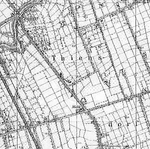
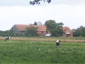
The village was founded in 1590 by Dutch colonists. In 1627, the village was granted a charter by Gustav Adolf and was settled primarily by the Mennonites of the Frisian fraction. After the approval of the Chemiski bishop, the residents erected a wooden church in Marksy, where soon afterwards (in 1791) established an independent community. In 1890, a new church was erected for the Markusy community. In 1776, the following surnames were mentioned in Rozgarciew: Allert, Dau, Hein, Kliwer, Koper, Cornelius, Nickel, Pauls, and Penner. In 1820, the village was inhabited by 66 residents, including 27 Mennonites. In 1868, petitions from Jezioro were signed by Heinrich Froese and widow Peters. In 1885, the village had 241 ha of land, 29 houses, and 200 residents, including 44 Mennonites. Village layout - single-homestead, modular village, located on terpy The cultural landscape has been undergoing a gradual degradation. The typical Dutch homesteads are disappearing. The houses last the longest, but they are often modified or replaced by new ones. The majority of buildings date from the 2nd half of the 19th and the beginning of the 20th centuries. The Catholic church, a school, and a manor are made of brick. In Dutch homesteads, old wooden homes have been replaced by brick buildings. The village still has several wooden buildings, but they are either modified or in very poor condition. The Catholic church from the 19th century with a 18th century presbytery, and a Mennonite school from 1930s have survived. There is also a Mennonite church from 1899, which in the post-war period served as a storage space for fertilizers (currently vacant), a Mennonite cemetery in a very poor condition with surrounding vegetation, and a linden tree alley. A field layout, canal and ditch network, and dirt roads lined with willows are detectable.
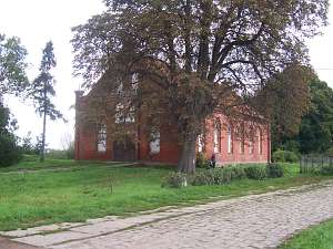 The Mennonite church is located in the southern section of
the village, on the eastern side of the Jezioro - Markusy road, facing it
with its gable. It is situate in the axis of the Mennonite cemetery, which
is located ca. 100 m to the east. The church dates from 1898/99 and was
built of brick on stone foundation. It has a rectangular layout,
single-space interior, which originally was lined with galleries supported
by wooden columns and a pulpit. Originally, the room had a wooden ceiling.
Currently, the building has an open suspended roof structure with a
ceramic roof. The northern and southern elevations have 6 axes with large
pointed-arch windows. The eastern and western elevations have 3 axes with
a wide, centrally located pointed-arch entrance with two pointed-arch
blind windows above (on two levels). The gable wall is topped by a block
cornice and heavy, brick, low pinnacles. The church had a pipe organ and
served the Catholic population in the first years after the war. Later, it
housed a shop under the gallery and then, in the next several dozen years,
the building was used by the PGR as a fertilizer storage space. Currently,
it is empty. The Mennonite church is located in the southern section of
the village, on the eastern side of the Jezioro - Markusy road, facing it
with its gable. It is situate in the axis of the Mennonite cemetery, which
is located ca. 100 m to the east. The church dates from 1898/99 and was
built of brick on stone foundation. It has a rectangular layout,
single-space interior, which originally was lined with galleries supported
by wooden columns and a pulpit. Originally, the room had a wooden ceiling.
Currently, the building has an open suspended roof structure with a
ceramic roof. The northern and southern elevations have 6 axes with large
pointed-arch windows. The eastern and western elevations have 3 axes with
a wide, centrally located pointed-arch entrance with two pointed-arch
blind windows above (on two levels). The gable wall is topped by a block
cornice and heavy, brick, low pinnacles. The church had a pipe organ and
served the Catholic population in the first years after the war. Later, it
housed a shop under the gallery and then, in the next several dozen years,
the building was used by the PGR as a fertilizer storage space. Currently,
it is empty.
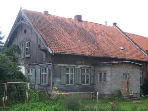
 No. 6 is a building situated on the southeastern
side of the road intersection, in a north-south axis. The building dates
from the beginning of the 19th century and probably had a small arcade,
which was later reduced to an attic room. It has a plastered
corner-notched log structure, and half-timbered, vertically boarded gables
and the attic room. Until recently, the plaster was decorated with low
relief carvings in the form of an oval cartouch. Recently, the elevations
have been modified by insulation and new windows. No. 6 is a building situated on the southeastern
side of the road intersection, in a north-south axis. The building dates
from the beginning of the 19th century and probably had a small arcade,
which was later reduced to an attic room. It has a plastered
corner-notched log structure, and half-timbered, vertically boarded gables
and the attic room. Until recently, the plaster was decorated with low
relief carvings in the form of an oval cartouch. Recently, the elevations
have been modified by insulation and new windows.
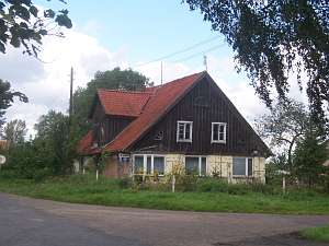
 No. 14 is a
Dutch homestead of the longitudinal type situated on the eastern side of
the road, facing it with its gable. The homestead includes a wooden
building from the 4th quarter of the 19th century, a brick/wood cowshed
and a barn. A second barn is located on the northern side of the yard. The
ground floor of the house has a corner-notched structure with quoins
covered with boards imitating Tuscan pilaster, while a pointing sill has a
half-timbered structure with vertical planking. A half-timbered gable is
vertically boarded. Window frames and the gable are decorated with
fretwork. The main entrance is located in the center of the 5-axial
southern elevation. The building has a modern porch, which replaced the
old wooden porch. No. 14 is a
Dutch homestead of the longitudinal type situated on the eastern side of
the road, facing it with its gable. The homestead includes a wooden
building from the 4th quarter of the 19th century, a brick/wood cowshed
and a barn. A second barn is located on the northern side of the yard. The
ground floor of the house has a corner-notched structure with quoins
covered with boards imitating Tuscan pilaster, while a pointing sill has a
half-timbered structure with vertical planking. A half-timbered gable is
vertically boarded. Window frames and the gable are decorated with
fretwork. The main entrance is located in the center of the 5-axial
southern elevation. The building has a modern porch, which replaced the
old wooden porch.
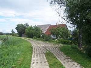
 No number - is a Dutch homestead of the
longitudinal type located in the colony in the eastern section of the
village. It was erected at the beginning of the 20th century and has a
traditional layout including a brick, 1.5 storey house (northern side) a
brick 2-storey cowshed, and a barn (all covered by a ceramic roof). No number - is a Dutch homestead of the
longitudinal type located in the colony in the eastern section of the
village. It was erected at the beginning of the 20th century and has a
traditional layout including a brick, 1.5 storey house (northern side) a
brick 2-storey cowshed, and a barn (all covered by a ceramic roof).
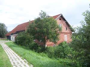 A Dutch homestead of the longitudinal type is situated in the
northern section of the village next to the Tina river flood bank, on the
southern side of the road (on the flood bank), facing it with its ridge (a
house on the western side). The brick house dates from the first quarter
of the 20th century. A Dutch homestead of the longitudinal type is situated in the
northern section of the village next to the Tina river flood bank, on the
southern side of the road (on the flood bank), facing it with its ridge (a
house on the western side). The brick house dates from the first quarter
of the 20th century.
 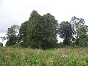 The
cemetery is situated on the eastern side of the church. There used to be a
tree lined alley. The cemetery has a square layout with two intersecting
alleys forming 4 sections. The cemetery layout is still detectable with
old linden trees and several gravestones: Anna Harms from 1901, the
Penners, the Bartels from 1931, Hans Jantzens from 1935, and Wilhel
Philipsens. The
cemetery is situated on the eastern side of the church. There used to be a
tree lined alley. The cemetery has a square layout with two intersecting
alleys forming 4 sections. The cemetery layout is still detectable with
old linden trees and several gravestones: Anna Harms from 1901, the
Penners, the Bartels from 1931, Hans Jantzens from 1935, and Wilhel
Philipsens.
Stankiewicz, s. 530, Filipska,s.36-37, ML, t. IV, s.313-14, Mamuszka, s.313-314; Lipińska, t. III, poz 121; AG, BF, Warchoł.
|
)