|
gm. Malbork, pow. malborski, woj. pomorskie
Until 1945, Kalthof TK (Schrőtter), Kaltenhoff (Endersch), Kaldowe Vogelsang

The village of Kałdowo (currently part of Malbork) is located on the western bank of Nogat. It incorporated two villages: Vogelsang (southern part) and Kalthof (northern part). At the end of the 18th century, Vogelsang had 19 houses and Kalthof - 17. The village was divided into Kałdowo village and town. The sources from 1776 mentioned 18 Mennonite surnames in Kalthof: Konrad, Dickgres, ENs, Epp, Fast, Claasen, Cornelius, Loewen, Penner, Reimer, Sudermann, Toews, Wiebe, and Wienp. In 1820, there were 29 Mennonites among the 215 residents of Kaldhof, while among 224 town residents, 34 were Mennonites. Vogelsang had 89 residents, including 9 Mennonites. In the second half of the 19th century, the village had 35 houses, 422 Catholics and Lutherans, and 25 Mennonites. Village layout - the village has been incorporated to the town of Malbork; it is located on the western bank of the Nogat and incorporates two historical parts with different layouts: the southern section is a flood bank linear village, while the northern section - a multi-street village. For centuries, the cultural landscape has been undergoing changes and the most recent modification was associated with the construction of a railway bridge and narrow-gauge railway. With these developments, the village began to loose its agricultural character. At the beginning of the 20th century, the buildings located next to the flood bank were still associated with farming, but division of the land reduced their open surroundings to house gardens. The northern section was urbanized more rapidly. This was the location of the traditional Nogat crossing and pontoon bridge until the bridge was completed. Traditional inns functioned in the area. At the end of the 19th century, the village had a factory. Fragments of cobble stone road along the Nogat flood bank (Wałowa street), 5 wooden buildings from the end of the 19th and beginning of the 20th centuries, and several older farming buildings from the end of the 19th century located along suburban Główna street have survived till the present day. .
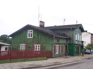
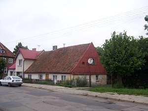
 No. 29 is a detached house situated on the northern side of
the road, facing it with its ridge. It dates from the 4th quarter of the
19th century. The building has a corner-notched log structure with covered
quoins, vertically boarded gables, a pointing sill, an attic room, and a
high tile roof. The frontal elevation has 5 axes with a centrally located
entrance with a porch. No. 29 is a detached house situated on the northern side of
the road, facing it with its ridge. It dates from the 4th quarter of the
19th century. The building has a corner-notched log structure with covered
quoins, vertically boarded gables, a pointing sill, an attic room, and a
high tile roof. The frontal elevation has 5 axes with a centrally located
entrance with a porch.
 No. 4 is a detached house situated on the
northern side of Główna street, facing it with its ridge. It dates from
the 4th quarter of the 19th century. The building has a corner-notched log
structure with covered quoins, vertically boarded gables, a pointing sill,
a high attic room above a walled-in arcade, and a low roof covered with
roofing paper. The frontal elevation has 9 axes with a 3-axial projection
of the former arcade and a centrally located entrance. No. 4 is a detached house situated on the
northern side of Główna street, facing it with its ridge. It dates from
the 4th quarter of the 19th century. The building has a corner-notched log
structure with covered quoins, vertically boarded gables, a pointing sill,
a high attic room above a walled-in arcade, and a low roof covered with
roofing paper. The frontal elevation has 9 axes with a 3-axial projection
of the former arcade and a centrally located entrance.
 No. 14 is
a detached house situated on the northern side of Główna street, facing it
with its ridge. It dates from the 4th quarter of the 19th century. The
building has a corner-notched log structure with a dormer and covered
quoins, vertically boarded gables, a pointing sill, an attic room, and a
lowered roof. The frontal elevation has 5 axes with a centrally located
entrance.& No. 14 is
a detached house situated on the northern side of Główna street, facing it
with its ridge. It dates from the 4th quarter of the 19th century. The
building has a corner-notched log structure with a dormer and covered
quoins, vertically boarded gables, a pointing sill, an attic room, and a
lowered roof. The frontal elevation has 5 axes with a centrally located
entrance.&

SGKP, t.III, s. 717;; Lipińska, t. III, poz. 108; AG; BF
|

 No. 29 is a detached house situated on the northern side of
the road, facing it with its ridge. It dates from the 4th quarter of the
19th century. The building has a corner-notched log structure with covered
quoins, vertically boarded gables, a pointing sill, an attic room, and a
high tile roof. The frontal elevation has 5 axes with a centrally located
entrance with a porch.
 No. 4 is a detached house situated on the
northern side of Główna street, facing it with its ridge. It dates from
the 4th quarter of the 19th century. The building has a corner-notched log
structure with covered quoins, vertically boarded gables, a pointing sill,
a high attic room above a walled-in arcade, and a low roof covered with
roofing paper. The frontal elevation has 9 axes with a 3-axial projection
of the former arcade and a centrally located entrance.
 No. 14 is
a detached house situated on the northern side of Główna street, facing it
with its ridge. It dates from the 4th quarter of the 19th century. The
building has a corner-notched log structure with a dormer and covered
quoins, vertically boarded gables, a pointing sill, an attic room, and a
lowered roof. The frontal elevation has 5 axes with a centrally located
entrance.&