|
gm. Markusy, pow. elbląski, woj. warmińsko - mazurskie
Until 1945 Markushoff TK (Gotha, Endersch, Schrötter)
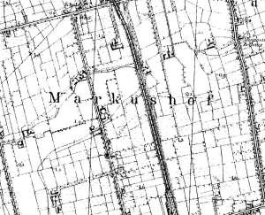
The village was founded in 1363. In Middle Ages, it had a manor house with a chapel. In 1590, Simon Bahr signed a contract for settling Dutch colonists in the village. Mennonites from Markusy belonged to the Frisian fraction of the Jezioro community. However, as a result of the 1791 schism, the Markusy Mennonites formed an independent community with their own house of prayer. In 1888, the communities were reunited and adopted the name Jezioro - Markusy. The sources from 1776 mention the following surnames: Allert, Bastvader, Boll, Dau, Froes, Froese, Gruntu, Harms, Holtzrichter, Jantzen, Lambert, Martens, Neysteter, Nickel, Puls, Penner, Peters, Philipsen, Quiring, Ridiger, Schroetter, and Siebert. In 1820, the village had 418 residents, including 162 Mennonites. The petition from 1868 was signed by: Heinrich Bächer, Peter Bestvader, Heinrich Froese, Aaron and Jacob Goerzen, Jantzen, Dietrich and Johann Pauls, and Heinrich Penner. In 1885, the village had 54 homesteads, 5 large farms, 76 houses, 689 Lutherans and Catholics, and 139 Mennonites. Village layout - single homestead village on terpy The cultural landscape has been relatively well preserved. The homesteads in the colony are mainly of the Dutch origin - the longitudinal type with wooden houses from the 19th century or masonry houses from the beginning of the 20th century. The majority of farming buildings date from the end of the 19th and beginning of the 20th centuries. Most of them have been modified, replaced, or demolished. Only 8 homesteads (out of 14 identified) with buildings survived until 1980s. The arcade house no. 13, a Mennonite cemetery (southwestern section of the village), landscape with colonial homesteads, terpy, homestead vegetation, a field layout, and a system of draining canals have survived. The house of prayer and the manor house have been destroyed. Currently, the village has a railway station and other buildings associated with the Elbląg - Prabuty line, which runs through the village. Small town houses and villas are being erected.
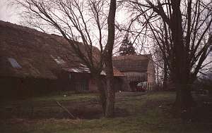
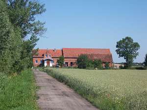 No. 67 is a longitudinal Dutch homestead situated in the
eastern section of the village, on the northern side of the Krzewsk -
Zwierzno road, facing it with its ridge (farming buildings are higher). It
was erected at the beginning of the 20th century in place an older
homestead. All buildings are made of brick and have ceramic roofs. There
is a granary (from the same period) in the southeastern section of the
yard. No. 67 is a longitudinal Dutch homestead situated in the
eastern section of the village, on the northern side of the Krzewsk -
Zwierzno road, facing it with its ridge (farming buildings are higher). It
was erected at the beginning of the 20th century in place an older
homestead. All buildings are made of brick and have ceramic roofs. There
is a granary (from the same period) in the southeastern section of the
yard.
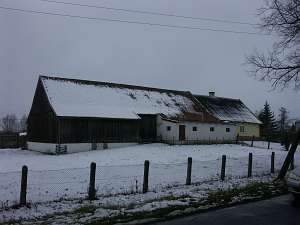 A building without a number is a Dutch homestead of the
longitudinal type situated in the eastern section of the village, on the
southern side of the Krzewsk - Zwierzno road, facing it with its ridge.
The farming section is much higher. The homestead dates from the beginning
of the 19th century. The residential section is made of plastered wood and
has a boarded gable and a rafter - two-collar beam roof structure covered
by asbestos tiles A building without a number is a Dutch homestead of the
longitudinal type situated in the eastern section of the village, on the
southern side of the Krzewsk - Zwierzno road, facing it with its ridge.
The farming section is much higher. The homestead dates from the beginning
of the 19th century. The residential section is made of plastered wood and
has a boarded gable and a rafter - two-collar beam roof structure covered
by asbestos tiles
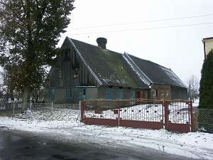 No. 77 is a Dutch homestead of the
longitudinal type situated on the southern side of the Krzewsk - Zwierzno
road, facing it with its gable. The farming section is slightly higher.
The homestead dates from the beginning of the 19th century. The
residential section is made of plastered wood and has a boarded gable and
a rafter - two-collar beam roof structure covered by asbestos
tiles. No. 77 is a Dutch homestead of the
longitudinal type situated on the southern side of the Krzewsk - Zwierzno
road, facing it with its gable. The farming section is slightly higher.
The homestead dates from the beginning of the 19th century. The
residential section is made of plastered wood and has a boarded gable and
a rafter - two-collar beam roof structure covered by asbestos
tiles.
 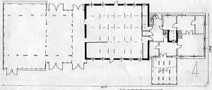 No. 13 is a longitudinal Dutch homestead situated in the
northern section of the village, on the northern section of the road,
facing it with its ridge (farming buildings are higher). The homestead was
erected in 1789 for an owner with initials BP. It was renovated in 1870s,
1934, and 1938. Until 1945, the farm belonged to Otto Goertz. The house is
made of plastered wood and has an arcade and quoins covered by profiled
and carved boards. A half-timbered extension is boarded vertically and
rests on 5 posts. The building has a queen post - purlin roof structure
covered by reed thatching and a bullseye window in the northern roof
slope. The interior has a two-bay layout with the large room in the
southeastern corner, a centrally located black kitchen, and two hallways:
an arcade hallway and an L-shaped utility hallway. The latter has a
staircases leading to the attic and cellar (by the kitchen) and 3 doors to
the cowshed and utility rooms. The eastern elevation has 3 axes and a
4-axial gable (lower section) with two windows enclosed by rhomboidal
skylights and a window located above. The western elevation has 5 axes
with an arcade supported by 5 posts (axes 1-3 from the west) and an
entrance in the 2nd axis. No. 13 is a longitudinal Dutch homestead situated in the
northern section of the village, on the northern section of the road,
facing it with its ridge (farming buildings are higher). The homestead was
erected in 1789 for an owner with initials BP. It was renovated in 1870s,
1934, and 1938. Until 1945, the farm belonged to Otto Goertz. The house is
made of plastered wood and has an arcade and quoins covered by profiled
and carved boards. A half-timbered extension is boarded vertically and
rests on 5 posts. The building has a queen post - purlin roof structure
covered by reed thatching and a bullseye window in the northern roof
slope. The interior has a two-bay layout with the large room in the
southeastern corner, a centrally located black kitchen, and two hallways:
an arcade hallway and an L-shaped utility hallway. The latter has a
staircases leading to the attic and cellar (by the kitchen) and 3 doors to
the cowshed and utility rooms. The eastern elevation has 3 axes and a
4-axial gable (lower section) with two windows enclosed by rhomboidal
skylights and a window located above. The western elevation has 5 axes
with an arcade supported by 5 posts (axes 1-3 from the west) and an
entrance in the 2nd axis.
No. 10 is a house located in the
northern section of the village, on the southern side of the road, facing
it with its gable. The building dates from the 2nd quarter of the 19th
century. Until 1945, it belonged to Hans Friese. It has a log structure
with quoins covered by boards imitating Tuscan pilaster. The building has
a rafter - collar beam roof structure covered by pantiles. The house has a
rectangular layout and a 2-bay interior with a wide eastern bay with the
large room located in the south eastern corner, a black kitchen in
the large room bay, an L-shaped hallway, which separates two rooms by the
western wall. The southern elevation has 2 axes and a 1-axial gable.
The eastern elevation has 6 axes and an entrance located in the 3rd axis
from the north.
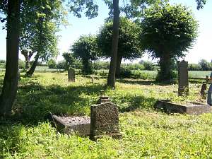 The Mennonite cemetery was probably established
at the end of the 18th century and has a rectangular layout (probably 4
sections) with a row of linden trees encircling the premises and remains
of alleys. A brick gate and numerous gravestones in the form of stalls and
obelisks have survived. The Mennonite cemetery was probably established
at the end of the 18th century and has a rectangular layout (probably 4
sections) with a row of linden trees encircling the premises and remains
of alleys. A brick gate and numerous gravestones in the form of stalls and
obelisks have survived.
SGKP, t. V, s. 109; Schmid, s. 121; ML, t. III, s. 43, , Lipińska, t. III, poz. 126, BF, MP Warchoł,
|
)