|
gm. Nowy Dwór Gdański, pow. nowodworski, woj. pomorskie
Until 1945 Jungfer TK (Gotha, Endersch, Schrötter) Keitlan, Keitelau - Swaryszewo
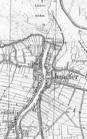
The present day village consists of two old settlements: Jungfer located by the road to Nowy Dwór and Keitlan situated to the south of Jungfer. The main section of the village - former Jungfer - was a fishing village founded in the 14th century and at that time located on coast of the Lagoon. It was incorporated in the Elbląg estate by a Kazimierz Jagiellończyk edict. In the 17th century, the village was partially incorporated in the Dutch colonization. In 1820, Jungfer had 639 residents, including 21 Mennonites. The sources from 1814-20 mention the surnames Bärg and Schräder. The village of Keitlau was an agricultural settlement and was settled by Dutch. In 1820, the village had 124 residents, including 13 Mennonites with the following surnames: Bencken, Claasen, Dick, Ens, Fast, and Friesen. The 1868 petition from Kępki was signed by a merchant J. Dyck. Village layout - multi street village formed from a water linear village located on both sides of the Panieński Canal with buildings along the westbound roads and a flood bank linear village in the (southern) former Keitelau section. The cultural landscape is in good condition. The spatial layout with numerous historical buildings has survived. There are ca. 40 wooden buildings, 6-7 longitudinal Dutch homesteads, 2 angular homesteads, and 1 cross-shaped homestead. The village also has a half-timbered parish church, masonry buildings from the beginning of the 20th century, and colonial houses from 1920s and 1930s. In the northern section of the village, there are remains of an unfinished lock and fragments of cobble stone surface on some streets - Wałowa, Żabia, or Mostowa. The field layout and drainage canal network are still detectable in the western and eastern sections of the village.
 No. 30 is a cross-shaped Dutch homestead consisting of a wooden house, a 1.5 brick/wooden cowshed, and two adjacent wooden barns. It is situated on a terpa in the southern section of the village, on the western side of Główna street, facing it with its ridge. The layout of the homestead dates from the 17th century and the house from the mid 1800s. It is a wooden (plastered) building with a vertically boarded gable, a queen post - purlin roof structure, and a high, ceramic roof. The gable elevation has 3 axes, a 2-axial gable with a semicircular skylight in the upper section. The side elevation has 5 axes. No. 30 is a cross-shaped Dutch homestead consisting of a wooden house, a 1.5 brick/wooden cowshed, and two adjacent wooden barns. It is situated on a terpa in the southern section of the village, on the western side of Główna street, facing it with its ridge. The layout of the homestead dates from the 17th century and the house from the mid 1800s. It is a wooden (plastered) building with a vertically boarded gable, a queen post - purlin roof structure, and a high, ceramic roof. The gable elevation has 3 axes, a 2-axial gable with a semicircular skylight in the upper section. The side elevation has 5 axes.
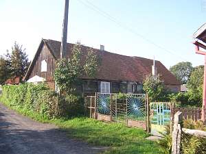 No. 3 is a longitudinal Dutch homestead (a barn has been demolished and a cowshed - modified) situated in the northern section of the village, on the western side of Główna street, facing it with its gable. The residential section dates from the 1st half of the 19th century. It has a log structure with walls reinforced with vertical braces, a vertically boarded gable, a rafter - collar beam roof structure, and pantile roofing. The gable wall has 2 axes with a single window in the gable. The side elevation has 4 axes. No. 3 is a longitudinal Dutch homestead (a barn has been demolished and a cowshed - modified) situated in the northern section of the village, on the western side of Główna street, facing it with its gable. The residential section dates from the 1st half of the 19th century. It has a log structure with walls reinforced with vertical braces, a vertically boarded gable, a rafter - collar beam roof structure, and pantile roofing. The gable wall has 2 axes with a single window in the gable. The side elevation has 4 axes.
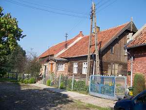 No. 10 is a longitudinal Dutch homestead situated in the western section of the village, on the northern side of Mostowa street, facing it with its ridge. It consists of a wooden house and a wooden/brick, 1.5 storey cowshed. The house dates from the 4th quarter of the 19th century. It has a log structure with quoins covered by boards imitating rustication. The pointing sill and the gable have vertically boarded, decoratively carved (at the bottom) half-timbered structures. The building has a queen post - purlin roof structure with collar ties and angle braces and a ceramic roof. The gable elevation has 2 axes, a two-storey gable with a rectangular window enclosed by smaller windows bound by segmented arches and a semicircular skylight above. The side elevation has 5 axes with an entrance and a porch located in the 3 axis. Window frames and beam notches are richly decorated. Wind ties joints and top plate supports are decorated with fretwork. No. 10 is a longitudinal Dutch homestead situated in the western section of the village, on the northern side of Mostowa street, facing it with its ridge. It consists of a wooden house and a wooden/brick, 1.5 storey cowshed. The house dates from the 4th quarter of the 19th century. It has a log structure with quoins covered by boards imitating rustication. The pointing sill and the gable have vertically boarded, decoratively carved (at the bottom) half-timbered structures. The building has a queen post - purlin roof structure with collar ties and angle braces and a ceramic roof. The gable elevation has 2 axes, a two-storey gable with a rectangular window enclosed by smaller windows bound by segmented arches and a semicircular skylight above. The side elevation has 5 axes with an entrance and a porch located in the 3 axis. Window frames and beam notches are richly decorated. Wind ties joints and top plate supports are decorated with fretwork.
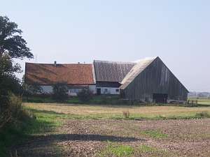
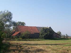 No. 29 is a Dutch homestead of the Winkelhoff type dating from mid 19th century situated in the southern section of the village, on the western side of the Główna street, facing it with the ridge. It consists of a wooden, plastered, single-storey house, a 1.5 storey, masonry, plastered cowshed, and a 1.5 storey, long, wooden barn perpendicular to the other buildings. There is a wooden granary/coach house in the southeastern section of the yard. No. 29 is a Dutch homestead of the Winkelhoff type dating from mid 19th century situated in the southern section of the village, on the western side of the Główna street, facing it with the ridge. It consists of a wooden, plastered, single-storey house, a 1.5 storey, masonry, plastered cowshed, and a 1.5 storey, long, wooden barn perpendicular to the other buildings. There is a wooden granary/coach house in the southeastern section of the yard.
Kerstan, 416-417; Piątkowski s. 62; Lipińska t. III, poz. 162; AG
|
)