|
gm. Stegna, pow. nowodworski, woj. pomorskie
Until 1945 Nickelswalde TK (Gotha, Endersch,Schrötter)
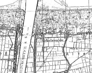
The village was established in 1337 on the coast. Initially, it was a fishing settlement, and subsequently was included in the Dutch colonization - the area to the south of the Vistula branch, Szkarpowy (Alt Binnen - Nehrung). Later the Vistula canal cut off the western section of the colonial settlement, forming the main route between Drewnica and the coast. The old road running through the eastern section of Alt Binnen Nehrung became the secondary axis of the southern section of the village. Village layout - multi-street village with a church and a cemetery in the western section and a colonial village on terpy in the southern section. Along Gdańska street, the cultural landscape formed primarily at the end of the 19th and beginning of the 20th centuries is in good condition; however, towards the center, the traditional architecture was replaced by modern houses and small hotels of various styles. The historical architecture includes wooden and masonry buildings from the 19th and 20th centuries, a tower, which remained after an old half-timbered Lutheran church located in the cemetery, 4 Dutch homesteads, and 4 longitudinal homesteads situated in the northern section, by Gdańska street .
  A building without a number is a longitudinal Dutch homestead
situated in the southern section of the village, on the western side of
the Drewnica-Mikoszewo road, facing it with its gable (ca. 100 m from the
road). A cowshed (beginning of the 20 century) is separated from the
residential section by a high fire wall (modified). A barn has been
demolished. The house dates from the 3rd quarter of the 19th century
and has a high, brick underpinning, a log structure with boarded quoins, a
vertically boarded pointing sill and gable, an overhanging attic room in
the eastern roof slope, a porch in front of an entrance, a queen post -
purlin roof structure, and sheet metal roofing. The southern elevation
originally had 3 axes and a two-level, 3-axial gable with a double window
bound by triangular shapes. The eastern elevation has 7 axes with the
entrance located centrally between two windows and a centrally located
attic room. There is a granary in the southern section of the
homestead. A building without a number is a longitudinal Dutch homestead
situated in the southern section of the village, on the western side of
the Drewnica-Mikoszewo road, facing it with its gable (ca. 100 m from the
road). A cowshed (beginning of the 20 century) is separated from the
residential section by a high fire wall (modified). A barn has been
demolished. The house dates from the 3rd quarter of the 19th century
and has a high, brick underpinning, a log structure with boarded quoins, a
vertically boarded pointing sill and gable, an overhanging attic room in
the eastern roof slope, a porch in front of an entrance, a queen post -
purlin roof structure, and sheet metal roofing. The southern elevation
originally had 3 axes and a two-level, 3-axial gable with a double window
bound by triangular shapes. The eastern elevation has 7 axes with the
entrance located centrally between two windows and a centrally located
attic room. There is a granary in the southern section of the
homestead.
 A building without a number is a house from a
longitudinal (angular?) Dutch homestead situated in the southern section
of the village, on the western side of the Drewnica - Mikoszewo road,
facing it with its gable (ca. 100 m from the road). (the adjacent
cowshed is modern; a barn - demolished). The house dates from the mid
1800s. A building without a number is a house from a
longitudinal (angular?) Dutch homestead situated in the southern section
of the village, on the western side of the Drewnica - Mikoszewo road,
facing it with its gable (ca. 100 m from the road). (the adjacent
cowshed is modern; a barn - demolished). The house dates from the mid
1800s.
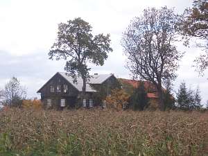
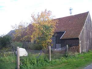
A building without a number is a longitudinal Dutch
homestead situated in the southern section of the village, on the eastern
side of the Drewnica - Mikoszewo road, facing it with its ridge (the
cowshed from the1930s is of the same height and is steparated from other
buildings by a high fire wall; a barn - taken down). The house was erected
in the mid 1800s and modified in the 1930s. It has a high underpinning, a
plastered, wooden structure, a vertically boarded gable, an attic room in
the western roof slope, a porch in front of an entrance, and asbestos tile
roofing. The interior and elevations have been modified.
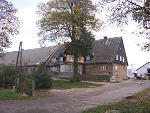
 A
building without a number is a longitudinal Dutch homestead situated in
the northwestern section of the village, on the southern side of Gdańska
street, by the Vistula flood bank, facing the street with its ridge (ca.
100 m from the road). A cowshed is separated from the residential section
by a high fire wall from the beginning of the 20th century (partially
demolished). A barn has been demolished. The arcaded house dates from the
mid 1800s. It has a high, brick underpinning, a log structure with
quoins covered by decoratively carved boards, an arcade (south side)
supported by 6 posts, vertically boarded gables, and a rafter - collar
beam roof structure with pantile roofing. The southern elevation has 3
axes, a 2-level gable with 2 axes at the bottom and a double window bound
by triangular shapes above. The eastern elevation has 7 axes with an
entrance in the 4th axis and an arcade in 3 central axes. A
building without a number is a longitudinal Dutch homestead situated in
the northwestern section of the village, on the southern side of Gdańska
street, by the Vistula flood bank, facing the street with its ridge (ca.
100 m from the road). A cowshed is separated from the residential section
by a high fire wall from the beginning of the 20th century (partially
demolished). A barn has been demolished. The arcaded house dates from the
mid 1800s. It has a high, brick underpinning, a log structure with
quoins covered by decoratively carved boards, an arcade (south side)
supported by 6 posts, vertically boarded gables, and a rafter - collar
beam roof structure with pantile roofing. The southern elevation has 3
axes, a 2-level gable with 2 axes at the bottom and a double window bound
by triangular shapes above. The eastern elevation has 7 axes with an
entrance in the 4th axis and an arcade in 3 central axes.
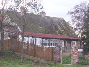
 No. 21
is a longitudinal Dutch homestead situated in the northern section of the
village, on the southern side of a street, facing it with its ridge. A
cowshed and a barn are higher and are separated from the house by a high
fire wall. The house dates from the 4th quarter of the 19th century. It is
a wooden house with quoins covered by boards imitating rustication, a
boarded gable, a low pointing sill, and a queen post roof structure
covered by asbestos tiles. The interior has been partially modified. The
eastern elevation has 2 axes and a single-axial gable. The southern
elevation has 3 axes. No. 21
is a longitudinal Dutch homestead situated in the northern section of the
village, on the southern side of a street, facing it with its ridge. A
cowshed and a barn are higher and are separated from the house by a high
fire wall. The house dates from the 4th quarter of the 19th century. It is
a wooden house with quoins covered by boards imitating rustication, a
boarded gable, a low pointing sill, and a queen post roof structure
covered by asbestos tiles. The interior has been partially modified. The
eastern elevation has 2 axes and a single-axial gable. The southern
elevation has 3 axes.
Lipińska, t. III, poz.244-245.
|
)