|
gm. Stegna, pow. nowodworski, woj. pomorskie
Until 1945 Bärwalde TK (Schrötter) - na planach Gotha i Enderscha nie oznaczony
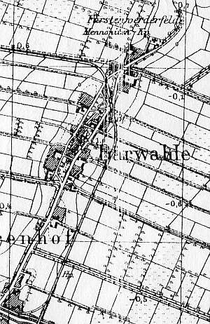
The village was founded by the Grand Master, Ludolf König in 1342 under the Chełmno law on 54 włókas. In 1565, Niedźwiedzica, including the villages of Żuławki and Nowa Kościelnica, was leased to Reinhold Krockow and in 1590, to Simon Bahr, who established an estate in its the southern section. Those three villages formed an estate with 175 włókas and 8 morgas of land. Mennonites appeared in the village in 1570 and initially belonged to the community "Wielkie Żuławy" in Gdańsk or Elbląg. The community became semi-independent in 1726, and fully independent in 1740. Since 1809, the village had its own Elder and in 1830 began using the name Żuławki - Niedźwiedzica (Fűrstenwerder - Bärwalde). The sources from 1776 mentioned Bestvader, Bruhn, Cronin, Dick, Ens, Esauł, Isaac, Claasen, Loewen, Nickel, Penner, and Reimer. In 1820, the village had 256 residents, including 69 Mennonites. The petition from 1868 was signed by Behrend, Cornelius, Heinrich and Jacob Epp, Joann Claasen, Abraham Kroecker, Peter Nickel, Peters, Peter Schulz, Peter Wieb, as well as Aron and Franz Wiens. Village layout - linear and square village in a north - south line a centrally located cemetery and church, a Mennonite cemetery, and a House of Prayer in the southern section. The cultural landscape has partially survived with a detectable spatial layout, a church surrounded by a functioning cemetery, and a lapidarium located in the old Mennonite cemetery (northern section). In 1980s, 5 out of 10 old homesteads had historical buildings; this number has not changed. Fragments of 3 Dutch homesteads, 7 wooden houses from the 19th century, a field layout, and a system of draining canals have survived.
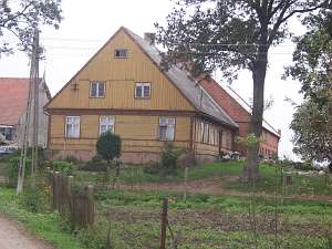 No. 13 is an angular Dutch homestead situated in the northern
section of the village, on the western side of the road, facing it with
its gable. The homestead includes a house from 1825 and a higher,
2-storey, 20th century cowshed. The house has a concreted underpinning, a
log structure - vertically boarded at the lower section and horizontally
boarded in the upper section, a vertically boarded gable, and asbestos
tile roofing. The eastern elevation has 3 axes and a two-level gable with
2 axes in the bottom section and a small, square window in the upper
section. The southern elevation has 7 axes and a richly decorated entrance
door in the 4th axis. The interior has been partially modified. A barn has
been taken down. No. 13 is an angular Dutch homestead situated in the northern
section of the village, on the western side of the road, facing it with
its gable. The homestead includes a house from 1825 and a higher,
2-storey, 20th century cowshed. The house has a concreted underpinning, a
log structure - vertically boarded at the lower section and horizontally
boarded in the upper section, a vertically boarded gable, and asbestos
tile roofing. The eastern elevation has 3 axes and a two-level gable with
2 axes in the bottom section and a small, square window in the upper
section. The southern elevation has 7 axes and a richly decorated entrance
door in the 4th axis. The interior has been partially modified. A barn has
been taken down.
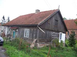 No. 16 is a house from a Dutch homestead of
probably longitudinal type situated in the central section of the village
between roads, facing them with its ridge. The house and a cowshed have a
common roof. The cowshed has been shortened and modified (a barn -
demolished). The house dates from the 3rd quarter of the 19th century. It
has a brick underpinning, a vertically boarded log structure with quoins
covered by boards imitating Tuscan pilaster, a vertically boarded gable,
and pantile roofing. The eastern/western elevation has 4 axes with an
entrance in the 2nd axis. The southern elevation has been modified and
currently has a single window in a 3-axial gable. The window is enclosed
by two skylights topped by triangular shapes. No. 16 is a house from a Dutch homestead of
probably longitudinal type situated in the central section of the village
between roads, facing them with its ridge. The house and a cowshed have a
common roof. The cowshed has been shortened and modified (a barn -
demolished). The house dates from the 3rd quarter of the 19th century. It
has a brick underpinning, a vertically boarded log structure with quoins
covered by boards imitating Tuscan pilaster, a vertically boarded gable,
and pantile roofing. The eastern/western elevation has 4 axes with an
entrance in the 2nd axis. The southern elevation has been modified and
currently has a single window in a 3-axial gable. The window is enclosed
by two skylights topped by triangular shapes.
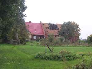 No. 19 is a
(probably) longitudinal Dutch homestead situated in the southern section
of the village, on the western side of the road, facing it with its gable.
The homestead includes a house and a higher, brick, 2-storey, 20th-century
cowshed. The house comprises two sections: a section from 1794 and a
building, which was added perpendicularly in the 4th quarter of the 19th
century (only a half has survived - modified). The older, wooden building
has a concreted underpinning, a log structure, which is vertically boarded
in the lower section and horizontally boarded in the upper section, and a
vertically boarded gable. The roof is covered by sheet metal imitating
tiles. The eastern elevation has 3 axes, a two-level gable (3 axes in the
bottom section) with a single window enclosed narrow skylights. Above,
there is a small window topped by a reverse ogee arch. The southern
elevation has 7 axes and a richly decorated entrance door in the 4th axis.
The interior has been partially modified. A barn has been taken down. No. 19 is a
(probably) longitudinal Dutch homestead situated in the southern section
of the village, on the western side of the road, facing it with its gable.
The homestead includes a house and a higher, brick, 2-storey, 20th-century
cowshed. The house comprises two sections: a section from 1794 and a
building, which was added perpendicularly in the 4th quarter of the 19th
century (only a half has survived - modified). The older, wooden building
has a concreted underpinning, a log structure, which is vertically boarded
in the lower section and horizontally boarded in the upper section, and a
vertically boarded gable. The roof is covered by sheet metal imitating
tiles. The eastern elevation has 3 axes, a two-level gable (3 axes in the
bottom section) with a single window enclosed narrow skylights. Above,
there is a small window topped by a reverse ogee arch. The southern
elevation has 7 axes and a richly decorated entrance door in the 4th axis.
The interior has been partially modified. A barn has been taken down.
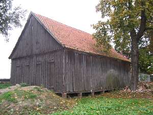 A
wooden granary/coach house from the beginning of the 19th century is
located in the southeastern section of the yard, facing the road with its
ridge. The building has a vertically boarded, framed structure and a
double-pitched roof covered by pantiles. A
wooden granary/coach house from the beginning of the 19th century is
located in the southeastern section of the yard, facing the road with its
ridge. The building has a vertically boarded, framed structure and a
double-pitched roof covered by pantiles.
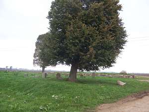 The Mennonite cemetery
is located in the southern section of the village, on the western side of
a road leading to the fields. It has a rectangular layout and 4 sections.
There is a stone foundation of a church in the southeastern corner and an
exhibition of gravestones (Peter Jantzen from 1850, Marie Enk, and Dyck)
in the remaining area. The Mennonite cemetery
is located in the southern section of the village, on the western side of
a road leading to the fields. It has a rectangular layout and 4 sections.
There is a stone foundation of a church in the southeastern corner and an
exhibition of gravestones (Peter Jantzen from 1850, Marie Enk, and Dyck)
in the remaining area.
 The old church was erected in 1768, rebuilt in
1829, and burned down in 1990. It was a wooden building with a log
structure - quoins covered by boards imitating rustication, vertically
boarded half-timbered gables, a queen post - purlin roof structure, and
pantile roofing. The church had a rectangular layout; the interior had two
rows of pillars with hanging galleries on the western, northern, and
eastern sides. The section under the eastern gallery was walled off and
had 3 rooms. The southern elevation had 7 axes, a double-leafed doors, and
small windows above in the 4th and 6th axes from the east. The building
had 2 large windows located between doors and low windows (in two levels)
in the 1st, 2nd, and 7th axes. The eastern elevation had 4 axes at the
lower level, an entrance in the 2nd axis from the south, 2 windows above,
and 2 windows in the gable. The western elevation had 3 axes and 2
levels. The old church was erected in 1768, rebuilt in
1829, and burned down in 1990. It was a wooden building with a log
structure - quoins covered by boards imitating rustication, vertically
boarded half-timbered gables, a queen post - purlin roof structure, and
pantile roofing. The church had a rectangular layout; the interior had two
rows of pillars with hanging galleries on the western, northern, and
eastern sides. The section under the eastern gallery was walled off and
had 3 rooms. The southern elevation had 7 axes, a double-leafed doors, and
small windows above in the 4th and 6th axes from the east. The building
had 2 large windows located between doors and low windows (in two levels)
in the 1st, 2nd, and 7th axes. The eastern elevation had 4 axes at the
lower level, an entrance in the 2nd axis from the south, 2 windows above,
and 2 windows in the gable. The western elevation had 3 axes and 2
levels.
Schmid, s. 24- 31, Stankiewicz, s.535, ML, t. I, s. 129; Lipińska, t. III, poz. 246, AG , BF, MP, Warchoł.
|
)