|
gm. Gronowo Elbląskie, pow. elbląski, woj. warmińsko - mazurskie
Until 1945 Wickerau Klein, Wickerau Gross
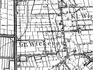
Wikrowo Małe was probably founded in the pre-Teutonic Order period. It was mentioned in 1357. Ca. 1300, the village had a manor, which initially belonged to Teutonic Knights, then to Elbląg Bridgettines, and in the 16th century, to the city of Elbląg (after 1945 - PGR Wikrowo). The village of Wikrowo Wielkie was mentioned in 1395; the name probably referred to the manor. The village of Wikrowo Małe was established in 1590 as a result of division of the manor land. The village was settled by Dutch colonists. In 1715, the settlements of Wikrowo Małe and Wikrowo Duże formed a single village. The land of the Stutthof estate (present day Helenowo) was part of Wikrowo. At the end of the 18th century, the village had 28 homesteads, and 36 Mennonites. In 1890, the northern section of the village was incorporated into the village of Władysławowo. At the beginning of the 20th century, the village had 229 residents and 347 ha of land. Village layout - three sections: a former manor in the western section (after 1945 converted into a state farm), a Waldhufendorf village on both sides of a north-south road, which in the northern section turns (mid 1800s) into a short linear village - Wikrowo Małe, and Wikrowo Duże in the southern section with buildings located on terpy along 4 local roads to Jegłownik and the Elbląg - Malbork road. The cultural landscape has been severely modified in the former manor area and by the burnt windmill (the last windmill out of 9 that functioned in the area). The historical architecture, including remains of 9 Dutch homesteads, has been transformed (old buildings have been replaced). Three wooden houses have survived. A system of draining canals (with polders), a field layout, and several terpy have survived.
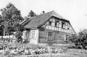
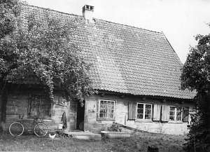
 No. 23 is a house from an angular Dutch homestead situated
ca. 50 m to the south of the Mennonite cemetery, on the western side of
the road, facing it with its gable. An old barn has been taken down; a
fragment of a cowshed has survived (separated from the house by a high
fire wall) . The house was erected in the 1st quarter of the 19th century.
Its corner-notched log structure rests on a stone underpinning. Quoins are
covered by boards with baluster profiles. The building has a vertically
boarded gable, a rafter-collar beam roof structure, a tile roof, and a
protruding top plate supported by decoratively notched ceiling beams. The
eastern elevation has 3 axes and a 3-axial gable with a window enclosed by
high quarter circular skylights and a semicircular skylight above. The
southern elevation has 6 axes and an entrance in the 3rd axis from the
west with small, pent-roofed attic rooms. No. 23 is a house from an angular Dutch homestead situated
ca. 50 m to the south of the Mennonite cemetery, on the western side of
the road, facing it with its gable. An old barn has been taken down; a
fragment of a cowshed has survived (separated from the house by a high
fire wall) . The house was erected in the 1st quarter of the 19th century.
Its corner-notched log structure rests on a stone underpinning. Quoins are
covered by boards with baluster profiles. The building has a vertically
boarded gable, a rafter-collar beam roof structure, a tile roof, and a
protruding top plate supported by decoratively notched ceiling beams. The
eastern elevation has 3 axes and a 3-axial gable with a window enclosed by
high quarter circular skylights and a semicircular skylight above. The
southern elevation has 6 axes and an entrance in the 3rd axis from the
west with small, pent-roofed attic rooms.
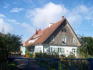
 No. 23 is a house
situated on the southern side of the local road. It dates from the 1st
half of the 19th century and until 1945 belonged to Froese. The building
has a log structure with quoins covered by boards imitating Tuscan
pilaster, half-timbered gables, and a partially-hipped ceramic roof. The
interior has a 2-bay layout with even bays and large rooms in the eastern
bay. The interior has been modified by the disassembly of the northern
section. The gable elevation has 2 axes and a 4-axial gable. The eastern
elevation has 6 axes and a 3-axial recessed arcade with a Tuscan portico
in the axes 2-4 from the north. Above the portico, there is a low
triangular gable with a low, wide segmented window. No. 23 is a house
situated on the southern side of the local road. It dates from the 1st
half of the 19th century and until 1945 belonged to Froese. The building
has a log structure with quoins covered by boards imitating Tuscan
pilaster, half-timbered gables, and a partially-hipped ceramic roof. The
interior has a 2-bay layout with even bays and large rooms in the eastern
bay. The interior has been modified by the disassembly of the northern
section. The gable elevation has 2 axes and a 4-axial gable. The eastern
elevation has 6 axes and a 3-axial recessed arcade with a Tuscan portico
in the axes 2-4 from the north. Above the portico, there is a low
triangular gable with a low, wide segmented window.
 No. 21 was a
house from a longitudinal Dutch homestead situated in the northern section
of the village, on the western side of the road to Władysławowo, facing it
with its gable. It was erected in the 1st quarter of the 19th century. The
building had a plastered log structure with quoins covered by boards, a
boarded gable, a brick foundation, and a rafter - two-collar beam roof
structure covered by thatching. The interior had a 2-bay layout with wider
southern bay, the large room in the southwestern corner, a central black
kitchen, and two separate L-shaped hallways. The gable elevation had 2
axes. The southern elevation had 4 axes, an entrance in the 2nd axis from
the north, and a bullseye. The building no longer exists. No. 21 was a
house from a longitudinal Dutch homestead situated in the northern section
of the village, on the western side of the road to Władysławowo, facing it
with its gable. It was erected in the 1st quarter of the 19th century. The
building had a plastered log structure with quoins covered by boards, a
boarded gable, a brick foundation, and a rafter - two-collar beam roof
structure covered by thatching. The interior had a 2-bay layout with wider
southern bay, the large room in the southwestern corner, a central black
kitchen, and two separate L-shaped hallways. The gable elevation had 2
axes. The southern elevation had 4 axes, an entrance in the 2nd axis from
the north, and a bullseye. The building no longer exists.
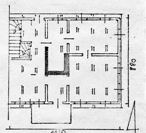 No. 4
is a house from a longitudinal Dutch homestead situated in the southern
section of the village, on the western side of the road, facing it with
its gable. It dates from the 3rd quarter of the 19th century. The building
has a log structure with quoins covered by boards imitating rustication, a
boarded gable, a brick foundation, a wooden, queen post - purlin roof
structure with a high, double-pitched roof covered by pantiles, and a
wooden, glazed-in porch on the southern side. The interior has a 2-bay
layout with a wider southern bay, the large room in the northeastern
corner, a black kitchen in the large room bay, and a rectangular
hallway with a staircase in the northwestern corner. The gable elevation
has 3 axes, a two level gable with 3 axes at the bottom, a window enclosed
by quarter circular skylights, and a semicircular skylight above. The
southern elevation has 5 axes and an entrance with a porch. A barn and a
cowshed have been demolished. No. 4
is a house from a longitudinal Dutch homestead situated in the southern
section of the village, on the western side of the road, facing it with
its gable. It dates from the 3rd quarter of the 19th century. The building
has a log structure with quoins covered by boards imitating rustication, a
boarded gable, a brick foundation, a wooden, queen post - purlin roof
structure with a high, double-pitched roof covered by pantiles, and a
wooden, glazed-in porch on the southern side. The interior has a 2-bay
layout with a wider southern bay, the large room in the northeastern
corner, a black kitchen in the large room bay, and a rectangular
hallway with a staircase in the northwestern corner. The gable elevation
has 3 axes, a two level gable with 3 axes at the bottom, a window enclosed
by quarter circular skylights, and a semicircular skylight above. The
southern elevation has 5 axes and an entrance with a porch. A barn and a
cowshed have been demolished.
 No. 9 was a house from a
longitudinal Dutch homestead situated in the southern section of the
village, on the western side of the road, facing it with its ridge. The
homestead was erected in 1814 by a carpenter with initials H.P. for an
owner with the same initials. The house had a log structure with quoins
covered by carved boards, a boarded gable, a brick foundation, a wooden,
rafter - two-collar beam roof structure, and pantile roofing. The interior
had a 1.5-bay layout with the large room in the southwestern corner, a
black kitchen in the large room bay, and two separate square hallways. The
gable elevation had 2 axes, a wide window, and a 3-axial gable with a
square window enclosed by rhomboidal skylights. The western elevation had
5 axes with an entrance located in the 2nd axis from the north. The
building no longer exists. No. 9 was a house from a
longitudinal Dutch homestead situated in the southern section of the
village, on the western side of the road, facing it with its ridge. The
homestead was erected in 1814 by a carpenter with initials H.P. for an
owner with the same initials. The house had a log structure with quoins
covered by carved boards, a boarded gable, a brick foundation, a wooden,
rafter - two-collar beam roof structure, and pantile roofing. The interior
had a 1.5-bay layout with the large room in the southwestern corner, a
black kitchen in the large room bay, and two separate square hallways. The
gable elevation had 2 axes, a wide window, and a 3-axial gable with a
square window enclosed by rhomboidal skylights. The western elevation had
5 axes with an entrance located in the 2nd axis from the north. The
building no longer exists.
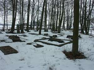 The village has one of the oldest
Mennonite cemeteries in the Żuławy region. It is located in the northern
section of the settlement (former, a part of Władysławowo), on a terpa, on
the western side of the road. It has a polygonal layout partially
destroyed by a new house (northern section). Old linden and hornbeam
trees, and dozen or so stalls and gravestones have survived. They date
from the 2nd half of the 19th and the 1st half of the 20th centuries and
include names Harms, Dück, Ens, and Neufeld. The village has one of the oldest
Mennonite cemeteries in the Żuławy region. It is located in the northern
section of the settlement (former, a part of Władysławowo), on a terpa, on
the western side of the road. It has a polygonal layout partially
destroyed by a new house (northern section). Old linden and hornbeam
trees, and dozen or so stalls and gravestones have survived. They date
from the 2nd half of the 19th and the 1st half of the 20th centuries and
include names Harms, Dück, Ens, and Neufeld.
Kerstan, s.406, Piątkowski, s.23, Mamuszka, s.114; ML, t.4, s.524.
|
)