|
gm. Zapolice, pow. zduńskowolski, woj. łódzkie
(Hol. Paprockie - Mapa Kwatermistrzostwa – 1830, Hol. - Paprotnia - Mapa Chrzanowskiego - 1848)
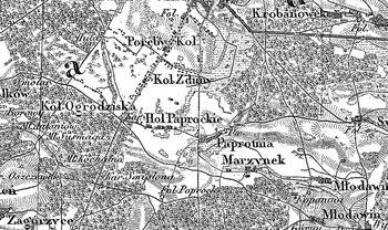
Former gentry village (owned by Jan Sulimierski), situated in the former Łask poviat, Zapolice commune, Strońsk parish. The first Hollanders were settled there in 1792. In 1886, Paprockie Holendry Stare (with people described as Polish-German) had the surface of 396 morgas. There were 18 settlements and 195 inhabitants, an Evangelic school and a cantorate. Paprockie Holendry Nowe had 19 settlements and 249 morgas of surface. Large linear village situated south-west of Zduńska Wola, with homesteads located on both side of latitudinal asphalted road. Houses built with their ridges and gables to the road. Traditional landscape related to the Dutch colonisation legible. Visible traces of land drainage carried out by the colonists – dewatering ditches and artificial planting of trees and shrubbery (especially on balks) – as well as the colonists’ cemetery.
The cemetery is situated in the forest, north of the line of buildings. Several dozen earth graves and gravestones were preserved there, part of which has German inscription. In the central part of the cemetery there is a modern wooden and metal cross with the figure of Christ.
SGKP, T. VII, Warszawa 1886, s. 851.
Łaski, Liber beneficiorum archidiecezji gnieźnieńskiej, wyd. J. Łukowski, t. II, 415.
|
)