POLISH VERSION


Home | Introduction | Download e-book | Conference 2001 | Special thanks | The note of law | Contact
Articles: Poland | Małopolska | Mazowsze | Ziemia Łęczycka | Żuławy | Nizina Sartowicko-Nowska | Ziemia Kwidzyńska | Ziemia Walichnowska | Ziemia Sieradzka | Ziemia Wieluńska
Dutch villages --> Ziemia Sieradzka
Kolonia Spycimierz
Następna miejscowość Next village
Explanations
Map of district

gm. Uniejów, pow. poddębicki, woj. łódzkie

(Hol. Człopki - Mapa Kwatermistrzostwa – 1830, , Spicimierz - Mapa Chrzanowskiego - 1848)

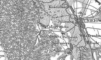
Village located in the former estate of the Gniezno archbishopric, in the Turek poviat, Kościelnica commune, Boleszczyn parish. In 1880 it was inhabited by people of different origins, mostly Germans. It was founded on infertile soils, flooded by the waters of Warta. It was settled by the Hollander colonists at the end of the 18th century.

Small linear village with colonial homesteads located on both sides of the road.

Landscape related to the Dutch colonisation transformed, illegible. Lack of material traces of colonists.

    
SGKP, T. I, Warszawa 1880, s. 862.


Home | Introduction | Download e-book | Conference 2001 | Special thanks | The note of law | Contact
Articles: Poland | Małopolska | Mazowsze | Ziemia Łęczycka | Żuławy | Nizina Sartowicko-Nowska | Ziemia Kwidzyńska | Ziemia Walichnowska | Ziemia Sieradzka | Ziemia Wieluńska

Copyright 2005 © jerzyszalygin@wp.pl