Jerzy Szałygin
Center for Public Collection Protection, Warsaw
The Olęder colonization of Mazowsze. Rural layouts and architectural types
One of the best preserved examples of rural architecture in the Mazowsze voivodeship are buildings and entire homesteads that represent styles typical of the Dutch (Olęder) colonization. In Mazowsze, this colonization included primarily floodplains of the Bug, Narew, Wkra, and Vistula rivers located between Kozienice and Płock.
It was an agricultural colonization in its entirety. The landform features of the colonized areas as well as the soil characteristics and productivity had a direct impact on the economic life and certain aspects of the Olęder material culture, for example, form of the settlement, agriculture, and architecture. Not only environment, but also the provisions of the settlement contract were a factor that determined and shaped the colonists' life. Most frequently, the Dutch were given a free hand in establishing their settlement and in deciding how many buildings and of what type it included; the contract only specified that the buildings were to be "Dutch". In some cases, however, the landowner explicitly stated his wishes, to which the settlers were to accommodate (e.g. Kępa Zawadowska, where it was specified that: "(...) the settlers are to erect buildings necessary to cultivate the adjoining land; the buildings are to be erected in suitable sites at the settlers' expense within four years. For each włóka, settlers are to build a timber house that is 24 ells long and 14 ells wide, and a planked barn for storing straw that is 20 ells long and 11 ells wide") [1] .
The uniqueness of the Dutch culture and farming style (e.g. settlement and building types) was so obvious and known that the contracts usually did not refer to these issues. The Dutch colonization was usually identified with not only the particular colonization law but also the specificity of the settlement forms and the uniqueness of the homestead appearance. Almost all villages were founded on the end moraine dunes and in the outwash fans frayed by the post-glacial waters. The characteristic feature of the Dutch colonization was the fact that each settler cultivated the land in one piece as opposed to the colonization under the German law, where the settle cultivated the land in the three-field system[2] . The land cultivated by the settlers in Mazowsze was usually characterized by low quality, sandy soils. However, this aspect was largely dependent on the localization; for example, the villages of Nowy Kazuń, Wilków Nowy, and Kępa Zawadowska, were founded on good quality soils, while the soil in Nowy Secymin or Śladów was of lesser quality.
In practice, all Olęders' obligations towards the landowner came down to rent paid in cash; whereas, in villages settled under the German law, the peasants, in addition to minimal payments in labor, were obliged to pay in produce. However, beginning in the 18th century, also the contracts of the Dutch settlers included additional obligations, for example: corvée labor, carriage obligation, obligations related to propination law, milling obligation, fishing ban, and others. The Kazuń settlement was required to "deliver ashes and wood fathoms collected on the leased land to the manor"[3] . The payable rent was proportional to the acreage of the owned land; the fee was collected once a year from the entire community at once.
The characteristic feature of the Dutch village was the fact that the residents maintained their own school and a teacher and performed their own religious observances. This way, they kept their language, culture, tradition, and Mennonite faith intact[4] . However, the settlers from Frisia dominated only in the initial period of the colonization (in Kazuń, Wymyśl Nowy, and Sady). With time, the settlers of German and Polish origin began to prevail and later, at the end of 18th and beginning of 19th centuries, the colonization was dominated by German settlers. They were arriving from the Polish lands under the Prussian rule and settling in the Kingdom of Poland. The colonists continued to be settled under the Dutch law, but they differed from the original settlers in their religion (Evangelical) and origin (German) [5] .
Despite the fact that the German colonists dominated, the religion of the original settlers survived; there still existed Mennonites congregations, for example in Kazuń. Even though, their community underwent a periodical decline in the middle of 19th century (many followers converted to Protestantism because of the old religion's severity), it was reformed and underwent revival, (foundation of the Mennonite Brethren, a very powerful religious faction).
The first wave of the settlers that reached the Mazowsze voivodeship at the end of the 18th century was of a specific character: the colonists usually stayed on the settled area until the first contract expired treating the Vistula riverbank villages as temporary stopover on their way eastward, where decrees of the emperor Joseph II and the tsarina Catherine II created favorable conditions for colonization of the lands of Ukraine, Powołże, and Wołyń[6] .
The second wave of settlers arrived between 1800 and 1806. The settlement of the colonists from Prussia and overpopulated regions of Germany was managed by the Prussian state officials. At that time, the majority of the remaining villages located in the said area were founded; for example, Nowe Grabie near Dobrzyków and Secymin Niemiecki (currently Nowy Secymin).
In the mid 1850s, the number of founded villages declined and granting of freehold to peasants ended the colonization. The villages settled under the Dutch law in the Mazowsze region survived practically unchanged until the outbreak of World War II.
The attempt to colonize Kępa Kosku (at the time called Kacza, later Saska) in 1628 is considered the first settlement of Olęders in Mazowsze[7] . The foundation act was recorded in the town register with the date April 4, 1628 and in 1650 the act was ratified by the king Jan Kazimierz. According to A. Wejnert, the town authorities allowed the Dutch to settle for a period of 40 years. They were required to pay rent, which equaled 24 groszy per morga (~1.4 acre) of land. The rent-free period was set to 5 years[8]. It is commonly believed that their stay was quite short. They left Saska Kępa as a result of the limitations of their rights imposed by the Warsaw city council. However, there is quite substantial evidence that their stay was longer than the duration of a single contract[9].
The next known contract is an agreement concluded between the settlers and Hieronim Radziejowski and ratified by the king Władysław IV in the Royal Register on June 9, 1645. The agreement is an example of the colonization of forests or their borders by the Dutch. The colonists were allowed to settle in the following villages: Baranów, Jaktorów, Kaski, Szczawinek. The contract provided for a 6-year rent-free period with 100 włókas of wastelands and forests to be put under cultivation; they were required to pay 30 florins per włóka. According to the inventory protocol of the Kaski lease from May 7, 1773, the contract provisions remained in force also after its extension: "The Dutch settled in the forests that belong to lease no 15. They do not serve in the manor, but provide transport for the manor six days a year; they deliver wood, like others. They pay 15 zlotys per powłóczka (according to the units from 1645)" [10] .
The subsequent village was founded in the vicinity of Płock. The settlement lease was signed in Troszyn on the Vistula river on May 12, 1759 between the royal land possessor Ignacy Cichocki and a Dutch representative. According to the contract, the settlers were granted standard privileges, for example free access to timber for building construction, but they were required to look after oaks that were undergoing impregnation in the waters of Vistula[11] .
The Dutch also settled in Kazuń in the vicinity of Nowy Dwór Mazowiecki. The Mińsk voivode Jan August Hilzen signed an agreement with the settlers' representatives, and according to the contract, they were to found a settlement in the cleared area on the riverbank[12] . In 1773, this contract was complemented with other provisions. The colonists were exempt from rent for 7 years (on the land allocated for clearing); they received firewood and timber free of charge for the erection of their homestead and for fencing For a proper fee, which was agreed upon each time with the landowner, they were also allowed to sell charcoal and wood from the cleared land in Warsaw. Additional groups of colonists were settled in Kazuń in 1773 and 1786. In 1795, the village was inhabited by 15 families (67 individuals), and in 1827, by 41 (314 individuals).
On February 5, 1778, Stanisław August, the king of Poland, confirmed the provisions of the "emphyteutic contract, under which the honest Dutchmen represented by Gutakowski, the Kampinos starost, are to settle on the wastelands of the village of Wilków" [13] . The settlers are also mentioned in a terrier from 1789[14] .
Wymyśle Nowe, founded by Kajetan Dębowski in 1781, was the next village settled by the Mennonites. Based on the contract, which was signed that same year, five settlers undertook to clear the forest in the granted area (half a włóka per settler). In exchange, they received 7-year rent-free period. After the land had been cleared, its acreage was measured in order to determine the settlers' duties: "After the rent-free period, the land should be measured by a certified surveyor. The surveyor will be summoned and will carry out the measurements at the settlers' cost. The land will be measured from the borders, that is, fences, with a measure that is used by the local Dutch. The settlers will pay two zlotys for each morga of good soil and four-sixths per a morga of sandy soil in two installments [...]. These people will pay eight days per year per włóka in corvée labor. Half will be paid as carriage to the manor and half with a scythe. The payment will begin immediately and still in the rent-free period at the rate one day per half a włóka"[15] .
In 1781, the Dutch founded another settlement in the vicinity of Nowy Dwór Mazowiecki - Kępa Nowodworska. The villages of Śladów and Secymin were established near the Vistula in the same period.
In 1785, the Dutch village Sady Niemieckie (near Płock) was granted the "wilkierz" (a system of administrative laws), which, for example, defined regulations for sale of Dutch farms: "A villager cannot sell or lease his house to an outsider before he notifies the Sołtys (village leader) Office that he so desires, and if during two weeks he finds no buyer, then he may sell the house to an outsider without any debts or other obligations. After the sale, the seller must properly transfer the ownership rights to the buyer and notify the neighbors about their agreement. If a neighbor desires to buy the house, he has the precedence before an outsider. And the precedence is such: the closest neighbor has the pre-emptive right, then the neighbor on the other side, and then a relative. If no such person desires to buy the house then the first buyer has the right, providing he is a righteous man and has proper certificates and documents.[...]" [16] .
Łęg Suchodół, which belonged to the owner of the dominium Świniary Stanisław Zabłocki, was settled in 1789. The villages of Łęg Januszew, Kępa Antonińska, Kępa Pieczyska and others were settled in the same period in the vicinity of Iłów[17] .
The last villages in Mazowsze were founded in the first half of the 19[th] century; one of them - Kępa Zawadowska - is currently located within Warsaw city limits[18] .
The most important task of the settlers in a newly colonized area was to drain and clear the land in order to put in under cultivation. The settlers dug draining canals and the dirt was used for building hillocks for homesteads and low flood banks. The artificial rises, where the settlers located their homesteads, frequently were of considerable sizes, for example, the still extant hillock in the village of Sady is 3-4 m high, 20 m wide and ca. 60 m long. However, it often happened that a hillock was built after the house had been erected. In such a case, the building was set on high pillars and the hillock was built afterwards.
There are two types of Dutch farms. The first one is a large acreage farm, which rarely occurred in the relevant area. The estate of colonist Brokopp from Wilków, who was the most important horse-breeder in the area, was an example of such a farm. Farms of this type were established on good quality soils during the initial period of the colonization in Royal and Ducal Prussia[19] .
Farms of the second type were established in the later period in the upper Vistula region (that is, in our area). These were usually small farms, which were less productive, poorer, and more fragmented than the large estates.
The settlers inhabited two types of settlements: linear and dispersed villages. The linear village was the oldest form of a Dutch settlement; the villages of this type were established on riverbanks or shores of water bodies. Each settler received a narrow strip of land, which was perpendicular to a river. Buildings were situated at the ends of these stripes, near the river. Individual farms were connected to the road running crosswise to the plots, along the water (frequently on top of the flood bank). The dispersed village had a different layout. Such settlements were usually founded in order to clear forests or to develop wastelands flooded periodically by rivers (Kazuń). Usually, the landowner allowed the settlers to clear a specific-size plot, which was marked off from the larger area of a forest or other type of wasteland. Each settler was free to choose a suitable plot for clearing on his own. The plots were allotted in one piece and their shapes resembled a square or a rectangle. Homesteads were usually situated in the plot centers and were connected with the main road, which ran through a village or in its proximity.
One of most basic aspects that distinguished the Olęder villages from villages in other areas was their architecture. Many of the buildings erected by the settlers survived to the present day in the surveyed area. The majority of them were built at the beginning of the 20th century; however, buildings dating from the 19th century are also common. The oldest building is a church from 1806 located in Sady. There are ca. 250 preserved examples of both farm and residential buildings in 40 villages.
The majority of preserved examples of the Olęder architecture are buildings called Langhof (O. Kloeppel) [20] or Niemiecki (German) (Wł. Łęga) [21] , which housed residential and farming sections under a common roof. The farming section included a cowshed and a barn. These buildings were very common in the 18[th] and 19[th] centuries particularly on areas colonized by settlers of German origin.
The layout and functions of such a house were closely related to the type of terrain on which the farms were to operate. In the face of recurring periodical floods, such arrangement was necessary to accommodate people and animals, as well as their food supplies under one roof.
The houses were usually situated along the river and along east-west or north-south (less common) lines. The residential section was located on the eastern side of the house. This arrangement had practical reasons: in case of a flood, the water washed out the waste matter from the farming section outside and not into the residential part. The central section of the home was occupied by a fire system, which included: a wide chimney, which comprised a smoke box and a bread oven, two kitchen stoves, and heaters. In the oldest houses, the system was usually made of bricks and in more recent homes, of tiles (especially a tiled stove in the room). The interior was usually divided into four spaces (two kitchens and two rooms arranged around the fire system). Larger and wealthier houses had two additional rooms, which were located on the gable side of a building and served as representative rooms. These rooms were richly decorated; their walls were covered with colorful plant-like and geometric designs, or even regional landscapes painted directly on the wall beams as it is the case in one of the homes. The residential section was separated from the farming one by a hallway and two bed-chambers, which protected the rooms against the transfer of dirt and inflow of unpleasant smells. The entrance to a cowshed was located centrally between two bed-chambers. The cowshed was equipped with stalls for animals. This section could also be reached through several doors located on both sides of the building. The barn was situated behind the cowshed; it had a centrally located threshing floor and two areas for storing grain or straw. Settlers frequently added an annex to the western gable wall and used it as a woodshed.
There are also other types of homesteads: Frisian and Polish[22] . The Frisian homestead included all buildings under a common roof, but the buildings were connected with each other at various angles. In the front section of the homestead, the settlers usually built a small residential annex, which was used as accommodation for the family elders. The proper residential building was situated behind the annex and was followed by a cowshed and a stable, and finally, a barn. The settlers added a room for fodder between the barn and stable, perpendicular to the building. The homestead of this type was characteristic of the first colonists in the Żuławy Wiślane region. There are only two examples of this type of the homestead in the surveyed area. The first one, dating from the beginning of the 19th century, is located in Sady near Płock. The second one is in Kazuń and dates from the beginning of the 20th century[23] .
The third type is the Polish homestead characteristic of the Polish colonists who began to settle in the area under the Dutch law in the 18th century. In this layout, all buildings (a house, a barn, and a cowshed) were detached from each other and were usually arranged in a rectangle. Homesteads of this type are present, for example, in Sady, Gniewniewice Folwarczne, and Wilków nad Wisłą[24] .
Pine wood was the basic building material, but poplar (walls) and oak (posts and ground sills) were also used. Some buildings were made of brick (e.g. house no. 29 in Świniary). The residential section had a corner-notched or tenon-post log structures, joined at corners by dovetail halvings. The farm section had a corner-notched (cowsheds) log structure or beam-post structure reinforced by angle braces and struts (barns). The farm buildings included in the homestead had identical construction. The walls (primarily in the cowshed, which did not have partition walls) were reinforced with a summer beam. Buildings were covered with double-pitched roofs with rafters connected by a mortise and tenon joints and reinforced by collar beams attached to ceiling joists by scarf joints. The roof truss was reinforced with queen posts and with ties (rarely). Straw and tiles were the preferred roofing materials until WWII. Currently, roofs are covered with roofing paper, plywood, or sheet metal.
The homesteads of the Olęder villages were very impressive in comparison to their Polish counterparts. The buildings were generally of considerable size in terms of their volume, had tidy surroundings, and were situated among orchards and gardens. Modern farming technology was quite profitable; as a result, Dutch homesteads looked very attractive. The Olęders kept their homesteads tidy, which clearly reflects their diligence and culture.
List of figures
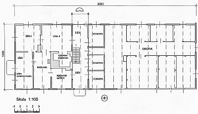
1. The ground plan of a house from the village of Sady, gm Czosnów, pow. Nowy Dwór Mazowieki. The house dates from 1853 and is an example of the most developed layout form of a Dutch building in Mazowsze.
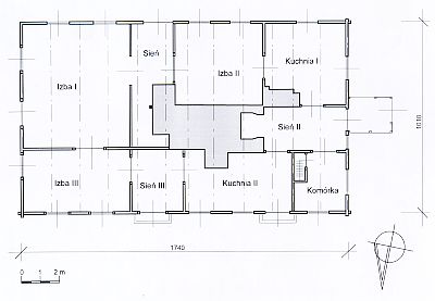
2. The ground plan of a house from the village of Wilków nad Wisłą 3, gm Leoncin, pow. Nowy Dwór Mazowiecki. The house date from 1902 and is an example of a building that only functioned as a residence. An extensive fire system occupies the central section of the building. The house is connected to a cowshed by a hallway, added to the western gable.
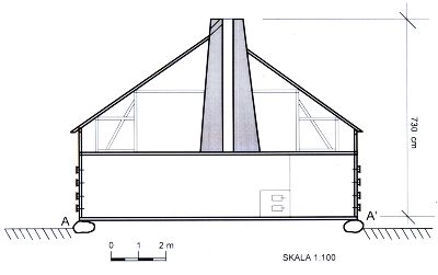
3. The cross-section of the house from the village of Wilków nad Wisłą 3, gm Leoncin, pow. Nowy Dwór with an extensive queen post system.
4. The oldest Mennonite church in Mazowsze, located in Sady (former Sady Niemieckie), gm. Gąbin, pow. Płock; the building dates from 1806.
5. The Mennonite church in Kazuń Nowy, gm. Leoncin, pow. Nowy Dwór Mazowiecki; the building was erected in 1892 in place of an earlier church, which was destroyed by flooding of the Vistula.
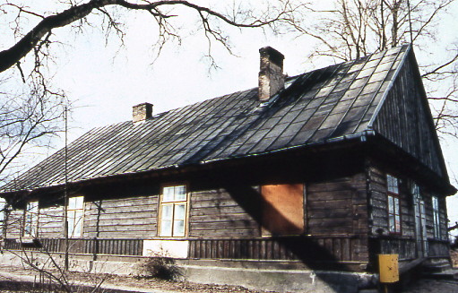
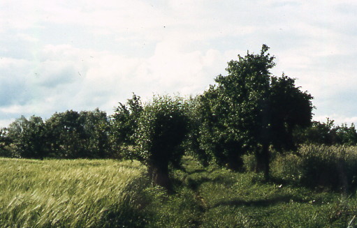
6. The most common type of a Dutch homestead; it housed a residential section and a cowshed under a common roof (Białobrzegi, gm. Bodzanów, pow. Płock).

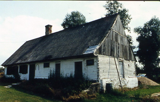
7. One of the two preserved houses of the Frisian type in Mazowsze; it is located in Sady, gm. Gąbin, pow. Płock.
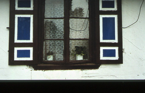
8. Some of the houses still have framed shutters going back to the colonists' time.
 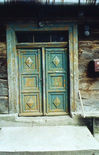
9-10. Examples of external doors that connected a yard with a hallway.
11. Roads and balks with rows of willows.
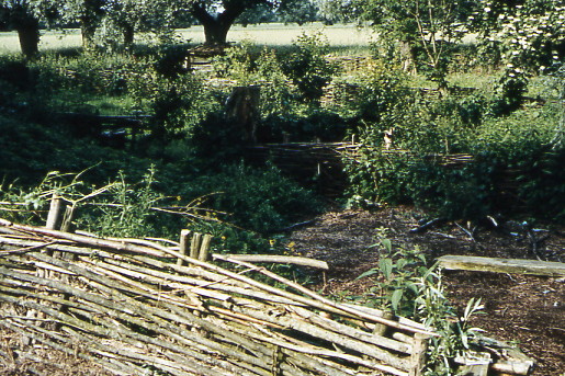
12. Even now, the osier is one of the basic materials for fences.
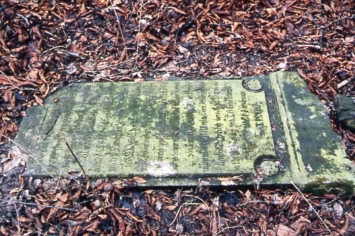
13. A grave stall from the Kazuń cemetery, gm. Leoncin, pow. Nowy Dwór Mazowiecki.
Footnotes
[1] J. Kazimierczak, Kępa Zawadowska - wieś olendrów w granicach Warszawy (1819-1944), Rocznik Warszawski, Vol. 5, 1964, p. 235-256.
[2] S. Inglot, Kolonizacja wewnętrzna a napływ Niemców do Polski od XVI do XVIII w., Kraków 1945, p. 41; S. Inglot, Problem kolonizacji flamandzko-holenderskiej w Niemczech i w Polsce, Kwartalnik Historyczny, Y. XLIII, Vol. 1, Lwów 1929; T. Baranowski, Wsie holenderskie na ziemiach polskich, Przegląd Historyczny, Vol. 19, Warszawa 1915, p. 73.
[3] Archiwum Główne Akt Dawnych (Main Office of Public Records; hereafter: AGAD), Metryka Koronna (Royal Register), 253 I 60.
[4] W. Rusiński, Osady tzw. "Olędrów" w dawnym woj. poznańskim, Poznań 1939.
[5] B. Schumacher, Niederländische Ansiedlungen im Herzogtum Preussen zur Zeit Herzog Albrechts (1525-1568), Lipsk 1903, p. 25.
[6] T. Baranowski, op cit., p. 71.
[7] Z. Kaczmarczyk, Kolonizacja Niemiecka na wschód od Odry, Poznań 1925.
[8] A. Wejnert, Opis historyczny trzech kęp na Wiśle pod Warszawą, Warszawa 1850.
[9] J. Szałygin, "Olędrzy" w Warszawie, Mazowsze, no. 14, 2001, p. 39 - 50.
[10] AGAD, Archiwum Skarbu Koronnego (Royal Treasury Archive), no. LVI, p. 4, II.f.28.
[11] Księgi Referendarii Koronnej z 1759 r., Warszawa 1957, vol. II, p. 662.
[12] AGAD, Księgi Grodzkie Zakroczymskie, no 120, f. 80
[13] AGAD, Sigillata 34, f. 88
[14] Lustracja woj. rawskiego 1789, pub. Z.Kędzierska, Warszawa 1971.
[15] W. Marchlewski, Mennonici w Polsce (o powstaniu społeczności mennonitów Wymyśla Nowego), Etnografia Polska, 1986, Vol. XXX, b. 2.
[16] Państwowe Archiwum Wojewódzkie (Governmental Voivodeship Archive) in Płock (hereafter: AWP), Akta notarialne kancelarii notarialnej w Gostyninie F. Czajkowskiego, no 270, 1.
[17] AGAD, Księgi Grodzkie Gębińskie i Gostynińskie from 1788-1791.
[18] J. Kazimierczak, op cit.
[19] O. Kloeppel, Die bauerliche haus- Hof- und Siedlungslanlage im Weischel-Nogat-Delta, Danzig 1965.
[20] O. Kloeppel, op cit.
[21] W. Łęga, Ziemia chełmińska, Prace i Materiały Etnograficzne, Vol.XVII, Wrocław 1961.
[22] W.Łęga, op cit.
[23] J.Szałygin, Osadnictwo holenderskie na terenie obecnego województwa płockiego, Mazowsze 1995, No. 6 (2/95); J.Szałygin, Osadnictwo olęderskie na terenie województwa stołecznego i jego ochrona, Ochrona i Konserwacja Zabytków, 1997, No. 4.
[24] J.Szałygin, Osadnictwo olęderskie ..., op cit.
|