Henryk Ratajczak
Department of Conservation, Nicolaus Copernicus University, Toruń
Issues related to conservation of arcaded houses in Żuławy based on two selected examples
Introduction
This article discusses factors that appeared after 1945 and pose threats to Żuławy arcaded houses and their outbuildings that were erected between the end of the 18th century and the middle of the 19th century. Based on the analysis of these factors, the author makes an attempt to provide solutions (on a micro scale) that would facilitate the protection of arcaded buildings.
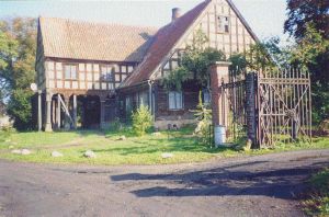
The rich artistic forms of these buildings, their architectural details, and applied technical solutions proved to be of such interest that the Zakład Konserwatorstwa Instytutu Zabytkoznawstwa i Konserwatorstwa, UMK (Department of Restoration Studies of the Institute of Historical Monument and Restoration Studies, Nicolaus Copernicus University) and Architecture Departments of Technological Universities in Oldenburg (Germany) and Groningen (Netherlands) undertook research of arcaded buildings located between Nowy Staw and Nowy Dwór Gdański. The research was carried out by students of these universities under the supervision of senior researchers between 1988 and 1996 during summer vacations. Each university conducted studies within their particular field; the basis of the project primarily consisted of documentation as well as measurement and drawing inventories of house examples selected by individual universities. The buildings date from the mentioned period. The discussions that accompanied investigations and especially questions posed by foreign guests drew our attention towards specific factors that occur in this area and pose threats to the historical buildings affecting their protection. Exchange of ideas with researchers from both the Dutch and German sections of Frisia (the Mennonite regions) made the author aware that in addition to common problems, the historical architecture was threatened by other, more complex factors that still occur in this region. Generally speaking, these problems did not appear until the post-WWII period. Greatly simplifying, we can say that they are underlain by political, sociological, economic, and technological factors. Most frequently, however, these types of problems coexist. In recent years, some of them have been discussed in numerous publications[1] . This report not only presents these problems, but also points out the ways of protecting this type of architecture. Two similar houses constructed with different technologies and from different materials have been selected in order to illustrate the problem. The houses are located in neighboring farms (no. 51 and 53; fig. 1) in the village of Marynowy, which is situated near the road from Malbork to Gdańsk and Elbląg, ca. 17 km to the north from the former capital of the Monastic State and ca. 6 km to the south from Nowy Dwór Gdański.
Characteristics of villages, farms, and buildings
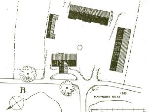
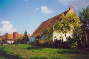
The mentioned houses are located in the southern section of the village of Marynowy, which was founded under the Chełmno law in 1321. Buildings of the village are arranged in a spindle-like shape and are situated along outer sides of two roads that meet at both ends of the village[2] (Il. 2). Small ponds, pastures (currently used as vegetable gardens), and a former inn are located between the roads, which are connected by numerous causeways. Currently, the western road is a part of the Malbork-Gdańsk road. A school, a church, and a cemetery were initially located near the village center next to the eastern dirt road, which currently is in a very poor condition. Residential buildings are situated next to both roads and face them with their ridges. Other elements of homesteads are located behind the houses with long strips of fields and pastures separated with canals.
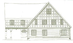
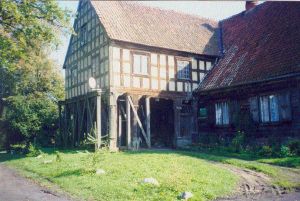
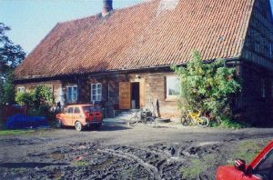
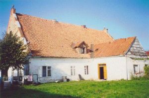
Building no. 51[3] (former 55) was built by Peter Loewen in 1803 (Fig. 3 and 4). The construction of the house was commissioned to him by Johan Jakob Ziemer and his wife. We also know the subsequent owners: Gerhard Claasen (since 1869) and Gustav Brucks (since 1909). All of them were Mennonites[4] . Building no. 53 (former 57) was probably built ca. 1825 (Fig. 5). Adolf Daniel (until 1910) and later Otto Lietz are mentioned among its last owners. They also were Mennonites[5] .
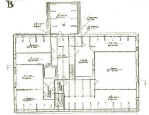
Both farms are of the same type (Fig. 6). Residential and farming buildings are situated on a slight, artificial rise in accordance with the Olęder tradition. The residential buildings face the road with their fronts. The farming buildings are arranged around a multiple-sided courtyard. A large barn, which also functioned as a granary, and included stables, a pigpen, a henhouse, manure separator, and a well is located on the right side of the house and is slightly removed from the road. A large cowshed was situated on the back side of the courtyard, across from the house[6] . A coach house (or a cellar), a vegetable garden, and an orchard were situated to the left of the house[7] . A drive way ran across the courtyard linking the road with the fields and pastures[8] .
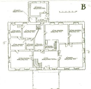
Both houses are of the same type, which is evident from the analysis of their projections and shapes. The houses have a rectangular layout with a side ratio of 2:1. They are covered with high roofs with the ridges parallel to the longer sides of the buildings. The front of the building had an arcade (with a passageway) supported by a dozen or so pillars and covered by a double-pitched roof. On the courtyard side, the house had a ground-floor kitchen arcade (Fig. 7).
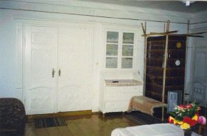
A part of the house has a basement (the cellar is located on the northern side). There were two hallways in the house: the main hallway located in the front section and the kitchen hallway, in the courtyard section. Both of them were located near the building axis and were connected by a passageway. Two spaces are adjacent to both hallways: a brick black kitchen (lit by a small window facing the front hallway) located on the right side and a room with a bread oven or a smokebox, on the left side[9] . Both spaces can be reached from the kitchen hallway. The heating stoves that were adjacent to rooms were fed from these spaces. Warm air heated the residential rooms, drying room on the first floor, while the smoke was used in a smoking chamber located in the attic. This complicated structure ends with a chimney duct and is known in the literature as a "bottle-shaped" chimney. The rooms on the ground floor were adjacent to the black kitchen. Two front rooms are particularly interesting: a large day room, which was quite presentable and decorative, located on the southwestern side and a smaller room located on the northwestern side. Other smaller bedrooms were situated in the eastern side and there also was a pantry in the northeastern corner of the building.
The northwestern corner of the front hallway had a staircase, which led to the first floor located under a high roof (Fig. 8). The stairs that led to the basement were located in the kitchen hallway.
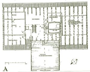
The attic (Fig. 9) was divided into rooms, a drying room, another smoking chamber, and storage spaces. The arcaded extension on the first floor had a summer room or (depending on the needs) was used as a loading space and was equipped with a lifting device (a winch). This space was connected to the other functional sections of the attic.
The buildings have interesting architectural details. For example, stairs, window and door frames, and the rooms, especially the elegant ones, have an exquisite decor (e.g. built-in closets, shelves or dressers).
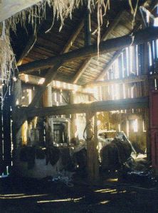
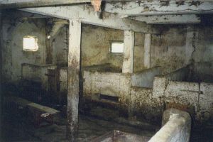
Also the farming buildings had an individual character, interesting furnishings, and attractive, but less exquisite details. Another noteworthy aspect is their interesting, often multi-story, and functional interior layout. Barns were lit by narrow windows at the ground floor level and had a curious infrastructure (e.g. internal well, manure separator, troughs, stalls for horses etc.). Unfortunately, the old cowsheds did not survive in either homestead.
In spite of being of the same type, the buildings, obviously, differ in many details. The greatest difference is the construction technology used during the erection of the buildings. Except for the brick cellar and the foundation, the older building has a corner-notched log construction and its arcade, the framed structure. The second house was made of brick with an exception of an arcade, which no longer exists.
The cellars and the foundation of the building no. 51 were made of bright red (almost pink) Dutch brick; while to fill in the frame of the arcade, builders used yellow Dutch brick. Building no. 53 is entirely made of red Dutch brick and all walls are plastered. The frame of the arcade used to be filled in with yellow Dutch brick.
Buildings have wooden ceilings, a wooden truss-work with a queen-post structure in the lower built-in section of the attic, and a rafter-collar beam structure in the upper section. Generally, floors are made of wide boards, but in the kitchens with stoves, they are made of compact limestone - reddish brown Swedish marble (Fig. 10 -12).
In homestead no. 51, the existing farming buildings were made of wood (framed structure planked and partially made of bricks) on brick and stone foundations. In contrast, the farming buildings of homestead no. 53 were made of bricks and left unplastered (Fig. 13). They were erected in the last quarter of the 19th century in place of the old ones.
Modifications and condition of the buildings after 1945
New tenants moved to homestead no. 53 in 1945, while homestead no. 51 became occupied in 1947. The current owners remember that the houses had no furnishings, for example, some doors and window frames were missing. Due to lack of archival materials, the additional data regarding the modifications introduced after the reoccupation was collected directly from the residents.
In 1953, the front hallway in building no. 51 was partially built in from the southern side and converted into a kitchen. In 1959, the kitchen arcade collapsed. In 1970, the black kitchen was partitioned and its southern part was converted into a bathroom. Also, a section of a former kitchen hallway was allocated for an additional kitchen and as a result, the door in the yard elevation was moved[10] . In 1994, the arcade was propped up by a supporting structure due to serious deformation and progressing deterioration of wooden pillars. In 2001, the left chimney (looking from the front) was repaired using home-grown methods and one of the owners was in the process of replacing doors and some of the window frames with those made of PCV. Some of the residential rooms have also been refurbished (painting, installing wood paneling) in recent years.
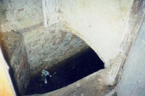
The arcade in building no. 53 collapsed in 1955, as a result, the shape of the building changed[11] . At the time, a part of tiles was transferred[12] . In 1970s, the owners did some renovation in the house interior: radiators were installed in part of the ground floor and one of the walls in the black kitchen was torn down. At the beginning of the 1980s, the cellars were flooded by subsoil water, which has not been pumped out to the present day. In the past decade, the residential spaces were painted; also, some improvements of water and sewage systems have been made.
In general, both houses are in very poor condition and are constantly deteriorating. It is particularly noticeable in elevations, for example, peeling plaster, missing window frames (Fig. 14) and inside the house, especially in sections of cellars (walls are peeling off, moisture and water are present) and attics (floorboards are decaying, tiles are loosening and falling).
The condition of the farming buildings is even worse (Fig. 6). Some farming buildings in both homesteads were disassembled or reduced in size after the war (the wood was used as fuel); only the barns-granaries have survived. In general, their technical condition is worse than that of the houses. The majority of the interior equipment was destroyed (stalls for horses, manure separators, pig pens, also, the majority of ground floor windows in the barns was boarded up). Fences surrounding the homestead were also destroyed; fragments of entrance gates are their only remnants (Fig. 15-19).
All demolition and renovation works were carried out by the owners themselves and with their own means, but without consulting the works scope with the historical monument office. Only the reinforcement of the arcade in building no. 51 (Fig. 14) was completed at the expense of the WKZ (Voivodeship Historical Monument Office) in Elbląg with the participation of a restoration specialist[13] .
All buildings in homestead no. 51 were made of wood, and in homestead no. 53, made of bricks. Currently, in the first homestead, the house is in best condition, while in the second one, probably the barn-granary.
Threats and causes of destruction
In addition to threats resulting from natural causes related to the used building material - internal factors[14] , there are other threats associated with external factors. The first group of these problems emerged after the end of the military activities and migration of people between 1945 and 1947 associated with these activities. After the inhabitants fled the approaching Russian army, the retreating German army broke floodbanks and water flooded vast areas including buildings[15] . However, even more serious damages were inflicted by the Soviet army, whose soldiers used the smaller wooden buildings, equipment, and architectural details as fuel. Then the buildings fell prey to looters, who also caused significant damage stealing equipment and elements of the infrastructure (the two discussed houses did not escape this fate). The buildings also suffered from the hands of the newcomers, who initially were coming to the area in small numbers. They disassembled uninhabited buildings using the material for heating and selling the equipment. Following the increased flow of immigrants ("Wisła" campaign), new problems emerged.
Up until the World War II, the Olęder farms functioned as multigenerational, single-family households. After the displacement of the few remaining "German" inhabitants, newcomers from the Eastern borderland and southeastern Poland appeared in the village of Marynowy. Their social origin was very diverse. In addition to former soldiers, among the new settlers were expatriates from the areas behind the Bug river as well as smallholders and manor workers from economically fragmented Kielecczyzna and eastern Podkarpacie (older residents of villages). Each farm had a considerable acreage and houses were large; therefore, after 1947, each house was given to at least two families in order to prevent ownership (kulaks) of vast land estates[16] . In subsequent years, this policy proved to have serious consequences for the condition of houses and farms. The houses and outbuildings were not always easily dividable into even halves; as a result, one of the families living in the house felt aggrieved[17] . As a consequence, farms did not have an administrator because the "wronged" families did not repair anything counting on revaluation of the estate division, while the second family did not know how the division would work out in the end and did not make any renovations either. Such situation inevitably led to a slow deterioration of buildings inhabited by these families. The problem still persists in the discussed buildings (building no. 53 is inhabited by three families).
After talking to older village residents, I concluded that during the 30-year post-war period any renovation or construction activities were initially paralyzed by the psychosis of a Russian-American war and subsequently by the cold war and a possibility of a nuclear attack. The constant fear that the former owners will return and reclaim their property also contributed to the lack of interest in proper maintenance of the buildings (residents even failed to carry out running repairs). This uncertainty did not begin to subside until the Gierek rule in the 1970s, after Poland signed a treaty with Germany. Similar fears aroused in recent years and are associated with joining the European Union. The residents are afraid that they will lose their farms as a result of property claims or that they will be repurchased by the former owners.
Both the uncertainty of post-war owners regarding stability in a new place and their habits and different cultural values are among factors threatening the historical buildings. The majority of these people came from upland areas, sometimes even from low mountains, and always from regions that were underdeveloped in terms of agriculture and civilization. Lack of knowledge resulting from these circumstances affected not only the equipment, which was often sold[18] . Some of the damage was done in good faith, for example, missing furnishings and frames (e.g. door leaves or shutters) were replaced with equipment from uninhabited houses (some shutters and doors in building Marynowy 51 came from no-longer extant buildings). This practice slightly transformed the original appearance of the buildings; therefore, surveying them today is difficult. Nonetheless, the practice still lingers on; elements from ruined homesteads are sold to art dealers and art "connoisseurs" or simply are being stolen.
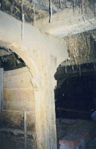
As a result of the ignorance and the sense of temporariness, the network of canals was poorly maintained (canal deepening works were extremely rare in Marynowy). Construction of primitive crossings over the canals and their silting up raised the level of ground water, which flooded the basements creating new problems (Fig 20, 10, and 11) Instead of draining the basements, the house owners partially filled them up with clay and in the cases where water was only dripping, the walls were plastered with a durable concrete mortar. It sometimes happened that the floor of a basement, which was partially filled up with hardened clay, was covered with a concrete slab, which reduced the height of a basement to ca. 1 m. Only several years later, the concrete was covered with salty water stains, which in turn caused peeling of bricks of foundation and higher sections of walls. Then, even more cement was applied. The final effect was an uneven sinking of a building, which was caused by deterioration of ceramic elements of foundation and subsequently deterioration of wooden and brick walls due to the capillary pressure. These types of damages were common in the village at the end of 1970s and in 1980s. Currently, this problem persists in house no. 51 where the owners additionally installed a central heating system in a section of the building; as a result, the internal walls and the bottle-shaped chimneys work as sponges sucking up water into increasingly higher sections of walls.
Historical houses that were destroyed this way were no longer inhabitable. The owners obtained a permit for demolition and erection of "modern" houses in their place (a new house in property no. 51 is located outside of the old homestead). The period of Gierek's rule and the beginning of the last decade of the previous century were the times when the largest number of new buildings were built on ruins of the old arcaded houses.
In the case of the discussed buildings, the situation was not so drastic. In order to improve the living standards, the houses were equipped with bathrooms and toilets. Depending on the owner's approach, these improvements were introduced with smaller or greater damage to the building as a historic monument. These modifications slightly changed the ground floor plan of the building and transformed the original layout through construction of partition walls in larger rooms. The results of the works that are carried out nowadays are usually modified elevations (Fig. 21 and 22). However, if no restoration works are done to the arcade of building 51, the shape of the building may be deformed[19] , similarly to building 53.
Division of larger farms into smaller ones, collectivization, enlargement of farms in recent years, economic and agricultural policies of the government, and farmers' desire to maximize profits from land also had significant impact on condition of individual homesteads. The former large (pre-war) farms in Marynowy were primarily oriented towards production of meat, milk, and dairy products (compare the German name of the village, Angerdorf - pasture). The incoming farmers, who were accustomed to operating small farms and rising small numbers of livestock, were not capable of managing large farms. Furthermore, the government policies proved to be "effective" in maintaining this situation. Contracting, small numbers of livestock, lack of appropriate equipment for land cultivation, preventing farm specialization, were responsible for a fall in agricultural production. As a result, farmers started to demolish some outbuildings. In both described homesteads, first, cowsheds and then coach houses and stables suffered this fate because entire produce and livestock fit in a barn well designed by the predecessors. The attic was adapted to serve as a granary. The wood from the demolished buildings was used as fuel and more durable materials were reused, for instance, to build garages. Currently, barns basically function as a casual storage spaces.
It is obvious that all those problems are extremely complex and therefore very dangerous to the existence of these historic monuments. It is impossible to clearly classify these dangers; for example, there are no strictly economic dangers or social ones; however, it is often the case that the human and economic factors are their common denominators[20] . The problems interweave and are deeply rooted in reality; they posses multiple layers, reflect human mentality and, also, are conditioned by history. I suppose similar problems exist in other regions developed by the Olęders. Therefore, it is difficult to find solutions that would facilitate protection of the arcaded houses (let alone homesteads).
It seems that during the entire post-war period, these buildings were devoid of any restoration specialist's attention. It appears that the activities of building conservation agencies were limited to inventorying, which became easier and easier due to decreasing numbers of buildings, issuing bans on any works on the buildings, and finally issuing permits for erection of new houses after the old buildings were destroyed. Such interpretation could not be more wrong. It is true that extensive restoration works were carried out relatively rarely in this region, for example, during 1950s and 60s, only several houses were thoroughly renovated[21] but it is known that the financial situation of the Państwowa Służba Ochrony Zabytków (National Agency for the Historic Monument Protection) permitted only necessary emergency and maintenance works, which was the case with the arcade of the Marynowy house 51 (Fig. 21) [22] .
Considering the current financial situation of the country and the Żuławy residents, it is difficult to arrive at feasible solutions of problems associated with the arcaded house protection. We can only hope that the Program Rozwoju Żuław (Żuławy Development Program) will bring some change for the better. Grassroots initiatives and projects also seem promising, for example, the "Mała Holandia (Little Netherlands)" project, whose goal is to establish an open-air museum of the Mennonite culture, which would present examples of buildings, homesteads, as well as the cultural and economic achievements of the former residents.
It is obvious that the transformation of the system is necessary, but also one has to agree with the researchers and activists, who propose directing more attention to educating the youth. Activities of Towarzystwo Przyjaźni Polsko-Holenderskiej (the Association of Polish-Dutch Friendship) and Stowarzyszenie Miłośników Nowego Dworu Gdańskiego "Klub Nowodworski" (the Society of Friends of Nowy Dwór Gdański) are particularly important. These associations promote protection of the region's historic monuments in magazines "Gazeta Żuławska" and "Nasz Tygodnik Żuławy". Establishment of the Muzeum Żuławskie is another step in this direction.
It is necessary that young people who were born and grew up in Żuławy felt that they themselves are the administrators of this region. It is extremely important for them to be aware that this is their heritage and they should be proud that they live in historic buildings with traditions. I would not like to listen again to words uttered bitterly with a characteristic accent by a late resident of Marynowy: "Mister, why do you, the students, and those Germans struggle so much? The fate of these ruins is already decided. Finished. We have never been rich here. Maybe some farmers were, but not for long. We can't afford renovation... Well maybe... If the whole house was mine, who knows? Mister, I am fed up with this guy and his family on the other side of the wall!!! You see, I am still not sure if this is mine for certain! And besides, politics... taxes... I am tired! I need peace in the house and in farming. That is why I am building a new house, over there, behind the old house."
First of all, however, I would not like the landscape from picture 23 to disappear...
Footnotes
[1]Cf. Piasek D.. Żuławy Wiślane, Pomerania 1996, no. 3 and 4. also: Okoniewska B., Gospodarka rolna i osadnictwo na Żuławach w okresie powojennym. Przeobrażenia strukturalne w latach 1945-1958, Warszawa 1992.
[2]Hawrylik R., Der Wohnbau der Mennoniten im Werder, [in:] Vermittlung von Dokumentationsmethoden an Baudenkmalen, Vol. 2, Beiträge zur ländlichen Siedlung an unterer und mittlerer Weichsel (u. a. Laubenhäuser), FO, Oldenburg 1997, p. 112.
[3]J. Stankiewicz mentioned the building in Zabytki budownictwa i architektury na Żuławach, Rocznik Gdański, Vol. XIV (1955), p. 148 - 169.
[4]Hawrylik R., op. cit., p. 113 and next
[5]Hawrylik R., op. cit., p. 118.
[6]This type of a homestead was already described, for example, by I.T. Baranowski, Wsie holenderskie na ziemiach polskich, Przegląd Historyczny, Vol. XIX, 1915 and Kloeppel O., Die bauerlische Haus-, Hof- und Siedlungsanlage im Weichsel-Nogat-Delta, Danzig 1924. T. Hanke carried out a more detailed resarch of a Żuławki homestead. It had a similar layout and was built by Loewen. , Studienstätte in Żuławki/Polen. in:] Vermittlung von Dokumentationsmethoden an Baudenkmalen. Teil 2. Beiträge zur Ländlischen Siedlung an unterer und mittlerer Weichsel (u. A. Laubenhäuser). Fachhochschule Oldenburg. Fachbereich Architektur. Oldenburg 1997. p. 263 - 274.
[7]There used to be a linden tree in front of the house on the left, and an oak on the right.
[8]Currently, the homestead can be reached from the road through narrow causeways between ponds and gardens.
[9]The only existing bread oven is in in house Marynowy 9.
[10]Soczewica K., Domy Petera Loewena na Żuławach i ich problematyka konserwatorska, manuscript of a master thesis UMK Toruń, p. 55
[11]Schmid B., Die Bau- und Kunstdenkmäler des Kreises Marienburg, Danzig 1919, dated the building to ca. 1850
[12]Hawrylik, op. cit., p. 118.
[13]J. Tajchman from IZK UMK (Nicolaus Copernicus University) in Toruń designed the supports; the project was financed by the then WKZ in Elbląg.
[14]Tajchman J., Czynniki warunkujące i kształtujące ochronę i konserwację zabytków architektury, [in:] Architectura et historia, Studia Mariano Arszyński septuagenario dedicata, Toruń 1999, p. 363 - 388.
[15]The results of the long-term exposure to water became evident only many years after the area had been drained.
[16]After 1948, many Żuławy villages were converted into PGRs (state farms) or compulsory farming cooperatives.
[17]Based on numerous conversations conducted by the author with the village residents.
[18]During the inventory carried out in one of the houses, remnants of a laundry room and a toiled were discovered in a basement. The residents were still using an outside toilet, explaining that the bathroom and laundry fittings were sold because they were often flooded and the place stank. The outside toilet was cleaner.
[19]Initial changes resulted from demolition of the kitchen arcade.
[20]Prof. Tajchman, op. cit, while writing about factors that condition renovation works and protection of historic monuments points out that some of them may also become threats.
[21]Piasek D., op. cit.
[22]WKZ (Building Conservation Agency) could not allow the arcade to collapse in front of the participants of the research team from Germany and Netherlands.
Literature (selection)
1. Baranowski I. T., Wsie holenderskie na ziemiach polskich, Przegląd Historyczny, T. XIX, 1915.
2. Hanke T., Studienstätte in Żuławki/Polen. [w:] Vermittlung von Dokumentationsmethoden an Baudenkmalen. Teil 2. Beiträge zur Ländlischen Siedlung an unterer und mittlerer Weichsel (u. a. Laubenhäuser). Fachhochschule Oldenburg. Fachbereich Architektur. Oldenburg 1997. S. 263 - 274.
3. Hawrylik R., Der Wohnbau der Mennoniten im Werder, [w:] Vermittlung von Dokumentationsmethoden an Baudenkmalen. Teil 2. Beiträge zur Ländlischen Siedlung an unterer und mittlerer Weichsel (u. a. Laubenhäuser). Fachhochschule Oldenburg. Fachbereich Architektur. Oldenburg 1997. S. 31 - 164.
4. Kloeppel O., Die bauerlische Haus-, Hof- und Siedlungsanlage im Weichsel-Nogat-Delta, Danzig 1924.
5. Okoniewska B., Gospodarka rolna i osadnictwo na Żuławach w okresie powojennym. Przeobrażenia strukturalne w latach 1945-1958. Warszawa 1992.
6. Piasek D., Żuławy Wiślane, Pomerania nr 3 i 4, 1996.
7. Schmid B., Die Bau- und Kunstdenkmäler des Kreises Marienburg, Danzig 1919.
8. Soczewica K., Die Häuser Peter Loewen im Werder und ihre denkmalpflegerische Problematik. [w:] Vermittlung von Dokumentationsmethoden an Baudenkmalen. Teil 2. Beiträge zur Ländlischen Siedlung an unterer und mittlerer Weichsel (u. a. Laubenhäuser). Fachhochschule Oldenburg. Fachbereich Architektur. Oldenburg 1997. S. 165 - 262.
9. Soczewica K., Domy Petera Loewena na Żuławach i ich problematyka konserwatorska, mps pracy mgr UMK Toruń, s. 55
10. Stankiewicz J., Zabytki budownictwa i architektury na Żuławach, Rocznik Gdański, T. XIV (1955), s. 148 - 169.
List of figures

1. The village of Marynowy Buildings no. 51 (on the left) and 53 (in the foreground) separated by a barn, which belongs to homestead no. 51. Author's photograph.
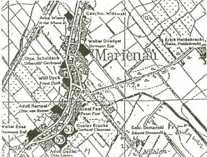
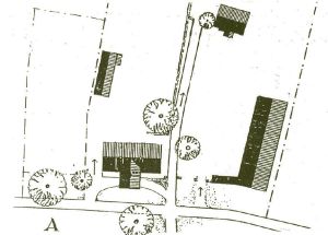
2. Fragment of a map o Żuławy from the 19th century with the village of Marynowy and location of the described buildings.
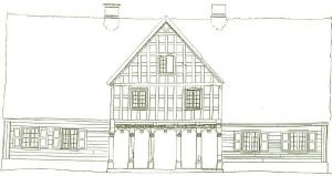 
3. Marynowy 51; Residential Building; A. Frontal Elevation; B. Southern Elevation. Inventory prepared by students of the FH Oldenburg.
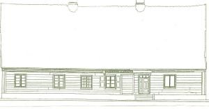 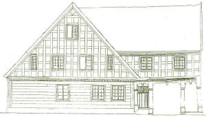
4. Marynowy 51; Residential Building; A. Eastern Elevation (rear). B. Northern Elevation. Inventory prepared by students of the FH Oldenburg.
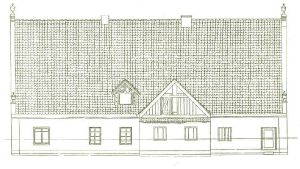 
5. Marynowy 53; Residential Building; A. Northern Elevation; B. Eastern Elevation. Inventory prepared by students of architectural conservation of the UMK Toruń.
6. Marynowy 51. Plan of the current homestead (A) and reconstruction design (B). Prepared by the author based on materials developed by R. von Oehsen from FH Oldenburg.
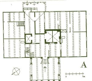 
7. Marynowy. Houses. Ground floor view.
A. House no. 51; Inventory prepared by students of the FH Oldenburg.
B. House no. 53. Residential building. Ground floor view. Current condition with the arcade destroyed in 1955 marked. Inventory prepared by students of architectural conservation of the UMK Toruń.
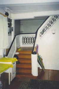 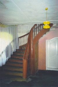
8. Stairs located in the southeastern corned of the front hallway. Author's photograph.
A. Marynowy 51. B. Marynowy 53
9. Marynowy. Houses. First floor view.
A. House no. 51; According to the inventory prepared by students of the FH Oldenburg.
B. House no. 53. Inventory prepared by students of architectural conservation of the UMK Toruń.
 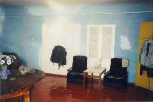
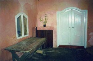
10. Large day rooms, view of the eastern wall. Author's photograph.
A. Marynowy 51. B. Marynowy 53.
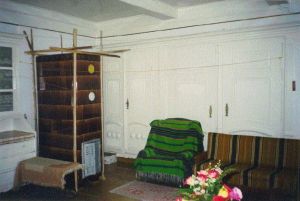 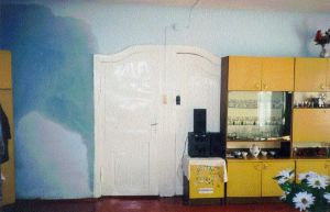
11. Large day rooms, view of the eastern wall with the hallway door and a dresser. Author's photograph. A. Marynowy 51. B. Marynowy 53 (serious damp spots visible)
 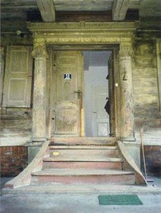
12. Marynowy 51. Residential building. Portal with an arcade.
A. Inventory prepared by students of the FH Oldenburg.
B. Current view. Author's photograph.
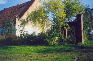
13. Marynowy 51. Residential building. View from the east. Picture by R. von Oehsen.
14. Marynowy 53. Residential building. View from the northeast. Picture by R. von Oehsen.
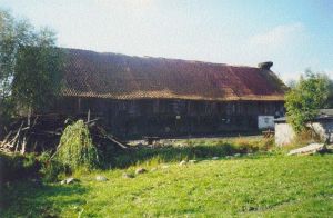
15. Marynowy 51. Barn. Author's photograph.
A. View from the courtyard (from the north). B. View from the south.
16. Marynowy 51. Frontal arcade. Author's photograph.
A. Temporary reinforcement of the arcade.
B. The room above the passage. View in the southwestern direction.
17. Marynowy 51. Barn. Author's photograph.
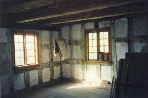
A. Interior with a manure separator. B. Detail of a pillar by stalls.
18. Marynowy 51. Barn. Author's photograph.
A. Western section - pig pen. B. Central section - stables with a trough.
19. Remnants of the entrance gate to the courtyard. Author's photograph.
A. Marynowy 51. B. Marynowy 53
20. Marynowy 53. Author's photograph.
A. Northwestern corner of the front hallway. Entrance to the basement flooded by subsoil water.
Southeastern corner of the front hallway. Damp stains visible of the wall.
21. Marynowy 51. Residential building. A. View from the northwest. B. View from the northeast. (new door and a PVC window are visible). Author's photograph.
22. Marynowy 53. Residential building. A. View from the southwest. B. View from the southeast.
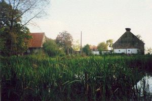
23. The village of Marynowy View of homestead no. 51 from the Malbork-Gdańsk road. Author's photograph
|