Olęders in Warsaw
Dutch colonization in Poland - articles
Centre of Art Collection Protection, Warsaw
The Dutch colonization in the fen regions of the Polish rivers, colloquially called the Olęder colonization, started in the beginning of the 16th century. On the one hand, the migration was caused by the opressions and pogroms of the religious groups founded in the Refomation time[1], such as Mennonites and New Baptists, on the other hand it had some pragmatic reasons. The migrants represented a high economical and cultural level which made them attractive as colonists. Having a long national experience in cultivation of the marshland, Olęders were able to bring the fens into prime by introducing a system of drains, dams and weirs. Dutch husbandry concentrated mostly on cattle and their fruit-farming was much more efficient, modern and better organized than a work at the serfs' fields [2]. The Olęders' presence in Poland was adventageous - they were able to farm seasonally flooded fields, they paid a rent and were held for quiet and hard-working people.
The first region to be settled was Żuławy Gdańskie. In the 15th century this fertile area was often flooded during spring and summer. The efforts to settle the local people in Żuławy did not bring expected effects, because the agricultural technologies used in Poland were not adaptable for cultivation of such a soil. Only Olęders could contrive to do it. The first Dutch settlement was founded in 1527 in Prusy Książęce, near to the present town Pasłęka (Preussische Holland)[3], and the other came shortly afterwards. Not much later Gdańsk started its economical activity.
The first settlement in Prusy Królewskie (Żuława Gdańska region), was a village called Tujce (Trigenhof). It was founded in c. 1530 by Faber, mayor of Gdańsk and a great proponent of the Dutch colonization in Żuławy.[4] The settlers were put not only in the areas posessed by Gdańsk, but also in the estate belonging to the Cisters monastry in Pelplin.
After the first and hardest years the Dutch colonization in Prusy Królewskie started to develop quickly. The settlers migrated directly from Holland or from Prusy Książęce, as they had been forced to leave by prince Albrecht's policy.[5] The next settlements were founded in Żuława Wielka and Żuława Mała, near Malbork, as well as in the Pruskie prefecture. In 1577 there was already 12 villages inhabited by the Dutch. In the same time the Dutch colonization started to spread upward the Vistula river.
The new settlements were being in the Sztumskie prefecture, in the Sartowicko-nowska valley, in the Dybowskie prefecture, in the region neighbouring Fordon, Bydgoszcz, Toruń (Nieszawa Wielka i Mała[6]) and in Ziemia Dobrzyńska region[7]. Going farther up the Vistula river, there are the Dutch villages both at the right bank (in the Bobrownickie prefecture) and at the left one (eastern Kujawy, Ziemia Gostynińska and Sochaczewska). In 1628 the Dutch colonization reached Warsaw and spread farther up to Kozienice. This movement was stopped in the second half of the 17th century by the war activities. The second wave of the migration movement started at the beginning of the 18th century. The colonists were settling down not only in the areas along Vistula, but also by other rivers. The regions colonized at that time are: lowlands in Kujawy region, the areas along Warta[8] and Bug[9] rivers, Wielkopolska (especially near Poznań). The migration wave reached Podolia, where some settlements were founded in 1780 in the county of Kodeń[10].
At that time the Olęder colonies have lost their economical and ethnic homogeneity. The Dutch or North German element still prevailed, however in some communities there were migrants from the other parts of Germany to be seen. Among the Dutch names there also occured the names suggesting Polish origins[11]. The terms "Olender", "Olęder", "Holender" do not define colonists' nationality and economical tasks of the colonies any more. These names were used rather in relation to a kind of social organization, to the system mirroring the former Dutch colonies.
The last Dutch settlements were founded at the end of the 18th and in the beginning of the 19th century. Some of them were situated near Warsaw. The colonists were comming from the regions under Prussian administration where the their privilages had been strongly limited by Fridrich Wilhelm's militarystic policy.
The edict of 1789 restricted the Dutchs' rights of tenancy and posession and obliged them to pay one Rhein gulden tax for the army disregarding the pacific rules of Mennonites religion. Their religious liberties had also been limited by subordinating the Mennonite Church to the Evangelic Church. The Dutch have been encouraged to settle in new areas by the authorities of Polish Kingdom. The permission to settle adressed to the "advantageous foreigners" was edited as far back as in 1816. The reason for it was a devastation of the country after the Napoleon wars. The importance of the colonization grew after the January Uprising (1863-1864). On the one hand, it was the time of crisis of the latifundia, on the other hand, the Tsar authority with its anti-Polish policy openly supported German colonization. Some of the colonists regarded their presence as a temporary stay on a way to Russia. The last villages on the Olęder law, though not founded by the Dutch Mennonite colonists any more, are the settlements situated in the present Warsaw district, such as Kępa Zawadowska (1819) and Holendry Tarchomińskie, both accessed under Warsaw administration in 1952. Describing the Olęder colonization the authors give much space especially to Kępa Zawadowska, remains of which are still to be seen. Meanwhile, there is a very interesting question to be answered about the length of the Dutch colonists' stay in Saska Kępa, their first settlement in Mazowsze region.
Saska Kępa have been called with several names throughout centuries. In the 16th century it was called Kawcza, in the 17th c. - Kosku, Kawcza, Holendry, Olędry, Kępa Miejska or Kępa Solecka, in the 18th c. - Holandia, Ostrów and finally - Saska Kępa.[12] In 1382 the place was put under Warsaw administration as a part of Solec district. The act of purchase was officially confirmed on 26 May 1382 by prince Janusz.[13]
At that time Saska Kępa was not inhabited. It was the place overgrown with osier beds, willows and some remains of oaks and it served as a huge reservoir of dry twigs and wood used by the town authorities to build fences, dams and leeves. The materials from Saska Kępa were used e.g. to pack the escarp under the Old Town and Krakowskie Przedmiescie street.[14]
In the end of the 18th century Kępa was still not inhabited. For that reason the idea to bring the Dutch colonists arose in Warsaw. The councillors were searching for the new incomes by cultivation of the wastelands. Aleksander Wejnert described the colonists as the immigrants from Frisian Island and Flanders.
They scattered around Europe because of the war started in 1584 between princes d'Orange and Philip II, king of Spain and Netherlands, and the persecutions on the religious ground following it[15]. The negotiations between the authorities of Warsaw and the colonists took some years. Several times, between 1624 and 1626, they were interrupted by plague. The colonists came to see their future homeland, Kępa, first on 11 May 1624 together with the Warsaw councillors.[16] Before the Dutch were officially given the land, in 1628 they had been used by the Warsaw authorities to clear up Góra Świętojańska (Gnojna) for 250 Polish zloty and to grub trees and dry twigs in Saska Kępa, used later for hardening and straightening the streets in Warsaw. Finally, the Dutch presence was legalized on 13 November 1628, after signing the contract by Andrzei Kos, Anus Pokręt, Joachim Darko and Anus Puck. The town was represented by the councillors and 20 citizens of Old Warsaw. The act of location was inscribed into to the council books on 4 April 1629 and ratified by king Jan Kazimierz on 10 December 1650.[17]
The contract consisted of 11 conditions:
1.Knowing that the colonists profess a religion different than Roman-Catholic, they were banned from their religious practices (including services and sermons in their private houses) and attempts to convert other people, e.g. servants, to their religion. Breaking this rule would be punished by confiscation of the land and annulation of the contract.[18] The colonists were forced to attend the services at the Catholic churches and to respect the offices of the Catholic priests, such as weddings, funerals or baptism.
2.The contract of lease was valid for 40 years. The rent (24 grosze for one morgue) was to be payed each year on the day of Candlemas. The colonists stayed under Mayor's and councillors' jurisdiction.
3.The colonists were relieved from paying a rent and a "szarwark" for five years. After this time their land, which was to be taxed by the town, had to be measured.
4.Olęders were allowed to meliorate the ground, grub the wood and build houses on the land they farmed.
5.They were allowed to build at their prime cost a mill which was to be used for the colonists' needs. If they milled comercially, they should share the incomes (payed in grain) with the town.
6.In the land leased to the colonists they were allowed to bake bread, brew beer, distil spirits, store and sell it, but they were banned to run any other business, even as partners of a company.
7.Olęders were obliged to pay any other taxes ratified by the king.
8.They were allowed to fish in the river and hunt the birds only within the town boundaries.
9.They were obliged to enable the inhabitants of Solec village to pasture the cattle in Kępa as this privilage had been given to them before signing the contract with Olęders.
10.The colonists could use the wood cut in Kępa for their own needs (heating, building fences etc.), but they needed a permission to grub wood for commercial reasons.
11.Olęders and their descendants had a right to prolong the contract after it would expire. In case they did not want a prolongation, they had a right to receive a reimbursment for the houses they had built.
After "wolnizna" (rent free time) was over, the land was measured following the 3rd paragraph of the contract. In 1636 the councillors appointed by the town council of Old Warsaw visited Kępa twice. Each time they spent there two days and were entertained by the colonists in traditional Polish way. At that time the colonists already used to farm cattle, produce dairy and grow vegetables. The bill made out to the councillors shows that they offered milk, sour cream, cheese, vegetables, poultry, fish and meat. A surveyor rented by the councillors to measure the land was payed 48 Polish złoty for his work. Five colonists, four of them of Dutch origin or at least with Dutch names, have leased 138 morgues of the land as follows:
1. Hanus Puczek- 25,
2. Joachim Olender - 15,5,
3. Piekarz Olender - 10,
4. Hanus Pokręty - 33,5,
5. Chiliński - 54.
Before 1643 the authorities of Old Warsaw ratified a new edict considering the Dutch colonists in Saska Kępa. Olęders were banned to sell the leased land or to give it to other colonists in a way different than by succession. The edict could be a proof that at least some of the colonists could not bear the liabilities of the contract and they tried to discharge it. J. Berger describing the reasons of the cutback mentions a different religion, ruinous floods of the Vistula river and devastation caused by the Polish-Swedish war (1655-60).[19]
In the current opinion this last edict, regulating the relations between Olęders and the council, formally closed the attempts to colonize Kępa. However, the direction of the development of this area has been kept. The incomes from Kępa were enlarged by leasing the following sections of the land to the Warsaw citizens for a rent.
Probably not all of the Dutch colonists farming in Saska Kępa broke or tried to cancel the contract. It is possible that some of them even stayed longer than for the period stated in the contract. In the studies concerning the Dutch colonization it is usually written that the colonists' presence in Saska Kępa did not last for long[20] - at most for the period of one contract. However, considering the information from the book Starożytności Warszawy by Aleksander Wejnert, one can state that if not all of the colonists, surely some of them stayed in Kępa longer.
This can be proved by two historical facts. Already in 1716 a part of Kępa took its name from one of the colonists who had signed the first colonial contract. His name was partly distorted, but it still shows that there was enough time for the name to get fixed in the town documents and the citizens' mind. In a deed signed by Marianna Dönhoff (maiden name Bielińska) a part of the land (98 x 56 prętów=gauge) leased by her in Saska Kępa was called Puckiego or Puckiera.[21] This name appeared in the certificates of 1628 as well as of 1636. In both documents there also occur two other colonists: Joachim Darko (in 1636 called Olender) and Anus (Hanus) Pokręty.
On the maps of Old Warsaw the names such as "Olędry"[22], Kępa HOlenderska[23], Hollanderie[24], Folwark Holandya[25] still occur. This can point to the longer presence of the Dutch in this area than it is believed now. Admittedly the place where the colonists settled down is situated in the Northern part of Kępa, near Stara Praga. On the map from 1732[26] there are three farmsteads among the cleared land, nowadays in the Praski Harbour area. On the maps from 1779 [27] and 1796 [28] one can notice three heights, admittedly aftificial, where the Dutch settlements were primarily located. The heights are situated among meliorative canals and groups of planted trees - the elements of the landscape so typical for the Dutch colonists.
The maps from 1818-19 and 1829 (over two hundred years after the colonists settled in Kępa)[29] are even more interesting. On the part of the map showing Saska Kępa from Praga side, four and five farmsteads located on the hills among the fields, canals and planted tree rows are clearly visible. Together with the other farmsteads on a flat ground they form a colonial settlement. Basing on the map scale (1:4200)[30] it is possible to point the size of the largest farmstead, which is approximately 29,4 x 12,6 m. All the buildings are typical for the Dutch colonial style. They are located along the river or perpendicular to it. At least four of the houses are disproportionatly long, which is typical for the colonization of Langhof style. All the buildings in the farmstead stand in one line under one roof. Such a formation consisted of the habitable part (divided mostly into four rooms surrounding the heating system), barn, cowshed and two rooms separating the habitable part from the animals' one and reducing the diffusion of animal smell.
Considering this information, it seems controversial that the Dutch colonists stayed in Saska Kępa for a short time and even broke the first contract. Although the contract strongly limited a very important thing - their right to practice their religion even at home, it seems that they must have stayed in Kępa for longer. Otherwise the Dutch names would not have existed on the maps of Warsaw. The fact that the continuation deed of the leasing deed has not been found is not that important. If the conditions of the first contract had not change, usually the continuation deed of a contract was not drawn.
On the maps of Old Warsaw there is also another settlement to be found: "Folwark Holendry". Its name comes probably from the Dutch neighbourhood in Kępa and the farm was presumably build in 1689 by Remigiusz Tryszena.[31], later hold by other tenants.
Much more information is to be found about Kępa Zawadowska[32] , a settlement 49 chełmińska morgues large (ie 5600-5700 m2). It was built by Potocki family in their properties in Wilanów in order to farm the wasteland on the Vistula bank. The first contracts were drawn in 1819 and 1823, but none of them was preserved until now. The next contract comes from 24 November 1824. Despite contract in Kępa Zawadowska has been signed two hundred years after the first contract concerning Saska Kępa, both documents still have much in common, though the settlement was founded by the German colonists. It prooves that the law on which the contracts between colonists and landlords based was solid.
The emphiteutic contract was drawn for fourty years, with a possibility to prolong the period. The colonists were obliged to pay 15 Polish złoty rent for each morgue of the farmed land per year. They were allowed to enlarge their fields by grubbing bushes belonging to the village area. However, the reverse often happened: the land melted because of the floods. To avoid the necessity to measure the land each time after flood it was stated that a 25 pręty (gauge) wide strip on the river side would be left uncultivated. The first settlements were founded near to Zawada village.
The colonists were allowed to use only the wood grubbed on their own land. It was forbidden to rent a part of the leased land, unless with its owner's written permission. Unlike the colonists in Saska Kępa they were not allowed to produce their own liquor or to bring it from elsewhere.[33] Only a landlord had the right to produce and distribute alcohol in his land.
The contract between the owner and the colonists was officially ratified on 22 June 1832. The colonists were obliged to fund and build in four years one house and one barn for each włóka (16,7-17,5 ha). A house (24 ells long x 14 ells wide) should be constructed of a sawed wood with a straw roof and a barn (20 ells x 11 ells) - of barge wood. However the colonists often built houses in a different stile explaining this by the lack of a proper raw material, which should have been provided by the owner.[34] But the real reason seems to be different. The colonists wanted to have houses more traditional for their culture, ie much longer, gathering the whole farmstead building under one roof. The example for such a farmstead made by the colonists is the last Olęder house which existed in the North-western part of the village until 1998.[35]
The contract differs much from the private one drawn on 24 November 1824. Besides, only three of twenty two names of the colonists were mentioned in the earlier contract. One of the differences is that, refering to the rule of a collective responsibility of the colonists in relation to the landlord, they were allowed to draw off a part of the land to somebody, who had joined their community. The newcomers' status must have been confirmed by the court. The rent was reduced to 6 Polish zloty per chełmińska morgue. The wood within the village boundaries stayed rent free for two and a half years.
The other financial duties - eg the military tax and a registration fee to the landlord - were also regulated. The colonists had to pay 750 Polish zloty for each włóka (= 30 morgues) in two instalments.[36] For the first year after the prolongation of a 40-year-long contract the colonists had to pay a double rent. The colonists collectively answered for their community to the landlord, always worked collectively, often collectively came into conflict with the court and payed a rent together, though the authorities counted the loan from each farmstead separately basing on the size of each field. The feeling of community was visible in acts of a neighbours' help, such as bringing wood for a house construction.
The configuration of the land adopted by the colonists to be farmed was changed several times. It was finally stated around the 50s of the 19th century. However in the first years of leasing the land it is hard to notice the borders between the farmsteads and settlements. Most of the allotments have an oblong shape and are situated perpendicularly to the Vistula river. All the allotments were linked to the main road going through the middle of the settlement since 1832. There were also two roads of less importance: one along the bushes by the river and another, later liquidated, going along the Wilanówka road. The roads to each settlement led from these main roads.
The houses were usually built on the heights. As the area was very flat, the colonists formed the hills themselves. However such heights were not high enough to protect the building from flood. Olęders had no fear of water and they did not hold flood to be a catastrophy if it swamped a basement for short. The animals, provisions and fodder were then put into the attic and the empty rooms were swamped. The water was making a lot of harm, but on the other hand it was useful. It was bringing a fertile mud, which stayed on the fences, bushes and trees around the house. The mud enabled good harvests and the water rinsed animal dung from the barn. It was possible thanks to the proper house location. The habitable part was always situated up the river current or perpendicularly to the current. For that reason flood was comming first to a habitable part and then to a barn taking away all the cattle dung to the fields. Bigger floods caused more devastation. The water was taking the farming land, bringing sand to a fertile soil which caused bad crops. The damages happened to be larger, like in 1841 when 19 of the colonists suffered from the flood, but only one farmstead was totally destroyed.
A characteristic of the houses in Kępa Zawadowska is a low framework of the 2 metres high walls covered with a roof 4 metres high. The inside of the colonists' houses did not differ much from the Olęders' houses in Mazowsze region. The buildings were divided into two parts: habitable one and a cowshed. A barn stood separately, always on a hill. The integral place of the house was a large hall, even to 5 metres wide, separating the habitable part from the space for animals. From the hall one could enter the kitchen and then a receptacle and a room. Next to this room there was usually another room called "dziad". The central place of the house was reserved for a heating system consisting of two kitchen parts (summer and winter), a bread stove and a cupboard for dishes which was arranged in a niche of a stove wall.[37]
The village built on the Olęder law was inhabited by the people with Polish and German names, as well as with the names suggesting their Dutch origin.[38]
The colonists were mostly farmers, though a handicraft was familiar to them. They built houses themselves and equiped them with a self-made furniture. It is hard to agree with J.Kazimierczak's theory that the houses were constructed by the Dutch colonists from the neighbouring Baranów, Jaktorów, Kasków or Szczawink, where they had been settled down by Radziejowski in the 18th century. There was no need for it. Each colonist had enough knowledge and skills to be able to build a house himself, with a help of his neighbours. Moreover they built the house of prayer themselves.
Colonists' farmsteads were self-sufficient. At the beginning they were no larger than 20 morgues. The settlers also used the 10 morgues large land in so called "Jezierzysko" next to Sucha Trawa.
Profiting from a good soil the colonists concentrated in the first years on farming grain and vegetables (potatos). In spite of the numerous financial duties to the court most of the farmsteads were in their prime, also thanks to the fertile silt brought by the river.
Beside agriculture the colonists farmed cattle. This was rather hindered by the obligatory fee for pasturage in the land belonging to the court and a lack of a pastureland within the community's land. Although the settlers lived by the river, they were not allowed to fish, unlike the colonists in Saska Kępa.
This restriction could have been linked to the fact that the colonists not always stand to their court duties. It was the rent arrears which caused changing a private contract to the formal one. Anyway, it did not bring a payment propmtness. J. Kazimierczak writes, that since the bank had been built by Vistula the colonists owned 436 morgues and 4 pręty (gauges) of the land, for which they should have payed 2616 Polish zloty. However the rent arrears of four colonists were 368 Polish zloty high on 1 Februar 1842 and on 21 January 1854 they reached 1300 Polish zloty.
Between 1824 and 1832 an inn was built next to Sucha Trawa on Vistula. It was open for the people rafting goods on the river.
The colonists were obliged to pay a rent for the land where the school stand. The building, constructed by them in 1834, contained teacher's appartment and served also as a house of prayer. This rent was a curiosity in the villages located on the Dutch law. The colonists payed 24 Polish zloty for 4 morgues per year. The house, existing till the 60s of the 20th century, was 24,27 m long and 9,9 m wide. A hall divided the building into two equal parts. The eastern one, 111,87 m2 big, was reserved for religious purpose and equiped with two rows of long benches. The eastern room was 49,5 m2 big and served as a class-room. Behind it there was a teacher's appartment consisting of a hall, large kitchen and two rooms. The shape of the building was similar to the former protestant chapel in Nowy Secymin (district Leoncin) built in 1924.
Protecting the land from Vistula's floods was a real struggle for the colonists. Initially, like elsewhere in the Olęder villages, the breaches caused by flood were filled up, the river banks were lined with willows and poplars, which served as a barrier for the most dangerous ice floes. Moreover the colonists sunk ponds for the oodles of water and ditches and they pushed the main stream of the river from the riverside by heaping up sand. The flood of 1844, which happened to be the most dangerous in the Olęders' land in the 19th century, showed the need of permanent protection of the river banks. In 1845 and 1846 the court innitiated the construction of a high embankment which would separate the river from the settlements. The inhabitants of Kępa Zawadowska were against it, because they did not perceive the flood water as a threat and catastrophy. However, in spite of colonists' recalcitrance the embankment was finished in 1860. J. Kazimierczak explains the colonists' aversion with their parsimony in giving money for the construction and with the fact, that the embankment crossed their fields reducing the incomes from harvest.
The World War I afflicted the colonists to a great degree. In 1915 the retreating Russian moved the whole population of the village to Russia and leased the land to the Polish farmers living nearby. The first colonists came back to the village in 1917. Their Polish neighbours were giving them back the land without problems and often helped them in the first months.
In the end of the 20s the agricultural structure of the alottments was changed: 40% for grain (rye, wheat, oat), 30% for potatos, the rest was reserved for fruit-farming, currant, gooseberry and raspberry bushes. The fruits and vegetables were easy to sell on the Warsaw market and the business was profitable. This caused the extention of the cultivation, especially of the strawberries introduced in the 30s. The amount of the animals on the farm (5 to 15 cows) also raised. The farms specialized in cheese and butter production. A good situation on the market engendered the growth of the village population by the wage-earning and seasonal workers, the half of which were Poles.
In the second part of the 30s the influence of the nazi ideology was visible in the village. The capitulation of the Polish army in 1939 confirmed the fears of the nazi agitation in the settlement. The power was given to the aggressor's adherents. After one year all the Poles living in peace with their neigbours were displaced and their farms were given to the colonists. During the war the village economy condition extremely developed. The production grew, new plants were introduced into cultivation (eg rhubarb). In 1942 the new higher embankment was constructed. The colonists' presence ceased in July 1944 when they have been evacuated to Germany before the Soviet offensive.
Even now in Kępa Zawadowska there are still some remains of the 200 years long colonization on the Dutch law, such as a system of fields divided by willows and poplars, the roads which are in use until now, the old embankment and two cementaries with old graves. Unfortunately, none of the traditional houses, perfectly harmonizing with the landscape of a Dutch village, remained.
Soon there will be no sign of the colonists' presence in Kępa Zawadowska, but the memory and written sources, like in Saska Kępa case. We should not loose these very last remains of the population settled in Warsaw on the Dutch law.
Illustrations:
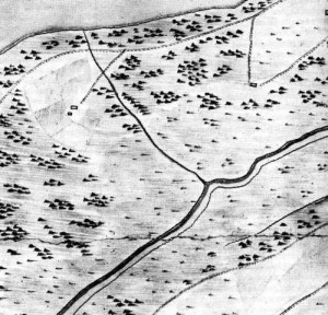
1. One of the three farmsteads in the Nothern Saska Kępa situated paralelly to the river among the fields. Map's section of: Plan glavnego v mazoveckom voevodstvie goroda ..., 1732, 4 steets, AGAD, Zb.kart. syg. nr 86-16, manuscript, in: B. Krassowski, B. Majewska, Plany Warszawy 1655-1814, vol. 3, Warsaw 1980
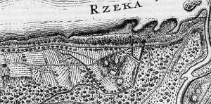
2. Northern part of Saska Kępa on the map of 1779. Three hills among meliorative canals and plants - a landscape typical for the Olęder colonization. Map's section of: Plan miasta Warszawy z przedmieściami, P. Hennequin, 1779, 1 sheet, Biblioteka Narodowa, syg. 1236, in: B. Krassowski, B. Majewska, Plany Warszawy 1655-1814, vol. 3, Warsaw 1980
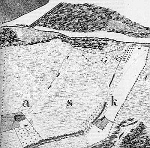
3. Three hills surrounding a ditch, still present on the map from 1796 (17 years later)Map's section of: Grundriss von Warschau, D.F. Sotzmann, 1796; 1 sheet, Biblioteka Publiczna m.st. Warszawy, Kartografia, syg. 1796, w: B. Krassowski, B. Majewska, Plany Warszawy 1655-1814, vol. 3, Warsaw 1980
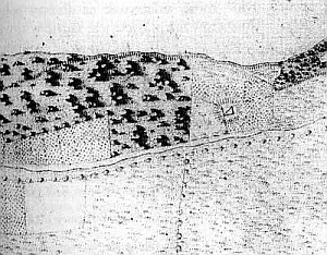
4. On the map from 1818-19 four farmsteads are still present. Unhabited house in the left upper corner. Map's section of: Plan miasta stołecznego Warszawy przez Officerów Korpusu Inżynierów w latach 1818-1819 i litografowany przez tychże roku 1822, 9 sheets, scale 1: 48 000, in: B. Krassowski, B. Majewska, Plany Warszawy 1815-1831, vol.4, Warsaw 1982

5. Map's section of Saska Kępa from 1829. Five Olęder farmsteads. Plan miasta stołecznego Warszawy z rozkazu JegoCesarzewiczowskiej Mości Wielkiego Xiecia Konstantego Cesarzewicza Naczelnego Wodza, przez Officerów Korpusu Inżynierów Woysk Król. Pols. Uskuteczniony 1829, 9 sheets, AGAD, scale 1:4200, in: B. Krassowski, B. Majewska, Plany Warszawy 1815-1831, vol.4, Warsaw 1982
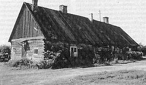
6. The last Olęder house in Kępa Zwadowska, existing until 1998
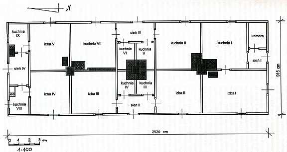
7. Basement of the house in Kępa Zawadowska. The initial disposition of the rooms has been totally changed. The Nothern part was reserved for animals, the Southern one was habitable. The original and only fire system was situated in the southern part of the house.
[1] W. Rusiński, Osady tzw. "olędrów" w dawnym woj. poznańskim, Poznań 1939
[2] B. Szczepański, Osadnictwo olęderskie w dobrach szlacheckich pow. konińskiego w XVIII w., Rocznik Wielkopolski, vol. I, 1973
[3] B. Schumacher, Niederlandische Ansiedlungen im Herzogtum Prussen. Leipzig 1903, p. 25
[4] K. Mężyński, O mennonitach w Polsce, "Rocznik Gdański", 1961/1962, No 20/21
[5] B. Schumacher, op. cit., pp. 37,96,100
[6] F. Szper, Nederlandische Nederzettingen in Westpruisen gedurende den Poolschen Tijd, Enkhuizen 1913, p. 238
[7] I. T. Baranowski, Wsie hOlenderskie na ziemiach polskich, "Przegląd Historyczny", vol. 19, 1915, p. 69
[8] B. Szczepański, op. cit., p. 71
[9] J. Górak, HOlenderskie domy nad Bugiem, Polska Sztuka Ludowa, No 1,1971, pp. 29-39
[10] I. T. Baranowski, op. cit., p. 71
[11] Ibid, p. 65
[12] A. Wejnert, Opis historyczny trzech kęp na Wiśle pod Warszawą, Starożytności Warszawy, vol. 3, Warsaw 1854
[13] J. Berger, Z dziejów Saskiej Kępy, Rocznik Warszawski, vol. 15, 1979, pp. 321 - 358
[14] H. Kersten, Warszawa Kazimierzowska 1648-1668, Miasto-Ludzie-Polityka, Warsaw 1971
[15] H. Faryna-Paszkiewicz, Saska Kępa 1918-1939. Architektura i urbanistyka, Studia z Historii Sztuki, vol. 43, Wrocław 1989
[16] A. Wejnert, op. cit.
[17] Księga radziecka miasta Starej Warszawy, Wrocław 1963
[18] This condition prooves an unawareness of Mennonic religion, which in that period banned its believers form the missionary activities. (J.S.)?
[19] J. Berger, op. cit.
[20] Z. Kaczmarczyk, op. cit.; R. Żelichowski, HOlenderscy osadnicy w XVII-wiecznej Warszawie, Warszawa. Etniczne i społeczno-kulturowe zróżnicowanie miasta (XVII-XX w.), ed. A.Stawarz, Warsaw 1998, pp. 5-16
[21] A. Wejnert, p. 92
[22] Plan miasta Warszawy z okolicami ...,M. Deutsch 1777, 4 sheets, AGAD, Zbiory Kartograficzne,. 86-18, manuscript, in: B. Krassowski, B. Majewska, Plany Warszawy 1655-1814, vol. 3, Warsaw 1980
[23] Plan de Varsovie ..., Le Rouge, 1768, 2 sheets, Biblioteka Narodowa, syg. 1068, in: B. Krassowski, B. Majewska, Plany Warszawy 1655-1814, vol. 3, Warsaw 1980
[24] Plan de Warsovie levé en 1779, 1 sheet, in: B. Krassowski, B. Majewska, Plany Warszawy 1815-1831, vol.4, Warsaw 1982
[25] Plan miasta Warszawy z przedmieściami, P. Hennequin, 1779, 1 sheet, Biblioteka Narodowa, syg. 1236, in: B. Krassowski, B. Majewska, Plany Warszawy 1655-1814, vol. 3, Warsaw 1980
[26] Plan glavnego v mazoveckom voevodstvie goroda ..., 1732, 4 sheets, AGAD, Zb.kart. syg. No 86-16, manuscript, in: B. Krassowski, B. Majewska, Plany Warszawy 1655-1814, vol. 3, Warsaw 1980
[27] Plan miasta Warszawy z przedmieściami, P. Hennequin, op. cit., Plan de Varsovie ..., Le Rouge, op. cit.
[28] Grundriss von Warschau, D.F. Sotzmann, 1796; 1 sheet, Biblioteka Publiczna m.st. Warszawy, Kartografia, syg. 1796, w: B. Krassowski, B. Majewska, Plany Warszawy 1655-1814, vol. 3, Warsaw 1980; Orginal Plan der Vorstadt Praga bei Warschau und der umliegenden Gegend ...von Rauch ... 1796, 2 sheets, w: B. Krassowski, B. Majewska, Plany Warszawy 1815-1831, vol.4, Warsaw 1982
[29] Plan miasta stołecznego Warszawy przez Officerów Korpusu Inżynierów w latach 1818-1819 i litografowany przez tychże roku 1822, 9 sheet, scale 1: 48 000, in: B. Krassowski, B. Majewska, Plany Warszawy 1815-1831, vol.4, Warsaw 1982; Plan miasta stołecznego Warszawy z rozkazu JegoCesarzewiczowskiej Mości Wielkiego Xiecia Konstantego Cesarzewicza Naczelnego Wodza, przez Officerów Korpusu Inżynierów Woysk Król. Pols. Uskuteczniony 1829, 9 sheet, AGAD, scale 1:4200, in: B. Krassowski, B. Majewska, Plany Warszawy 1815-1831, vol.4, Warsaw 1982
[30] Plan miasta stołecznego Warszawy z rozkazu JegoCesarzewiczowskiej Mości Wielkiego Xiecia Konstantego ... (as above)
[31] A. Wejnert, p. 92
[32] J. Kazimierczak, Kępa Zawadowska - wieś olendrów w granicach Warszawy (1819-1944), Rocznik Warszawski, vol. V, 1964, pp. 235-256
[33] Ibidem, p. 237
[34] Ibidem, p. 241
[35] J. Szałygin, Osadnictwo hOlenderskie na terenie wojwództwa stołecznego i jego ochrona, "Ochrona i konserwacja zabytków", No 4/96
[36] J. Kazimierczak, p. 239
[37] Ibidem, p. 241
[38] In 1824 the contract was signed by: Gotlieb Gabrych, Jakub Hiense, Wilhelm Liedke, Karol Górski, Jan Szule, Jerzy Dalman, Mateusz Kletke, Jakub Jkkert Krystyn Weis and Michał Jezierski. Ibidem, p. 241
|


