|
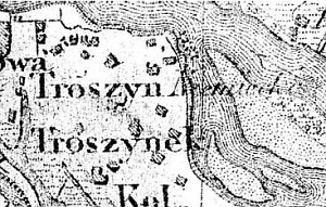
gm. Gąbin, pow. płocki, woj. mazowieckie
The settlement was founded by the Dutch under agreement singed on May 12, 1759 between royal land possessor Ignacy Cichocki and a Dutch representative. The settlers, on the virtue of this contract were granted general privileges, for example they were able to cut trees for building purposes free of charge but also were required to look after oaks that were undergoing impregnation in the waters of Vistula. The colonists, under the contract, settled on 61 włóka, 2 morga, and 141 pręt between the village of Troszyn Polski and the riverbed. Additional contracts were concluded in 1765 and 1783. In 1798, a German-Evangelical elementary school was established; 37 students attended classes. Before WWII, The present village of Nowy Troszyn included three groups of settlements, which were called Troszyn Niemiecki, Troszyn, and Troszynek. In 1892, the village had 27 houses and 252 residents, who cultivated 548 morga of land. The farms were characterized by an advanced level of land cultivation. The economy was based on cattle and horse raising, cheese production, and fruit farming. At the end of the 19th century, the orchards, which had ca. 40 morga in area brought from 150 to 400 rubles per morga in revenue; the meadows (260 morga in area) were used to pasture horses and cows and yielded 70 rubles yearly.
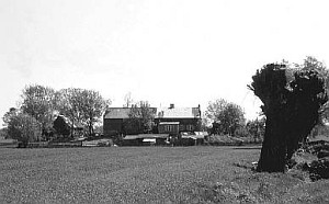
Nowy Troszyn is a linear village located to the east of Dobrzyków on the southern side of Vistula; the homesteads are located along the old flood-bank on man-made hillocks, on the southern side of the paved road and the metalled road that runs on top of the flood-bank. Ponds collecting water excess are located between the homesteads and the road. The homesteads can be reached by elevated dirt roads.
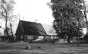
The cultural landscape is very well preserved - it has a detectable field layout with willows planted on the balks, drainage canals, and wattle fences. Examples of traditional Dutch buildings have survived.
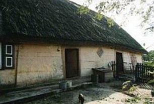
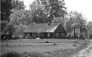
 Building no. 21 is a wooden house, erected ca. 1900; it is located in the western section of the village (it probably has an old number) in a four-building homestead. The second barn is located behind the house (on the south-western side) on a separate man-made rise. The homestead also includes two newly erected farm buildings. The homestead is surrounded by a wattle fence. A well and a masonry cellar are located in the south-eastern corner of the homestead. Building no. 21 is a wooden house, erected ca. 1900; it is located in the western section of the village (it probably has an old number) in a four-building homestead. The second barn is located behind the house (on the south-western side) on a separate man-made rise. The homestead also includes two newly erected farm buildings. The homestead is surrounded by a wattle fence. A well and a masonry cellar are located in the south-eastern corner of the homestead.
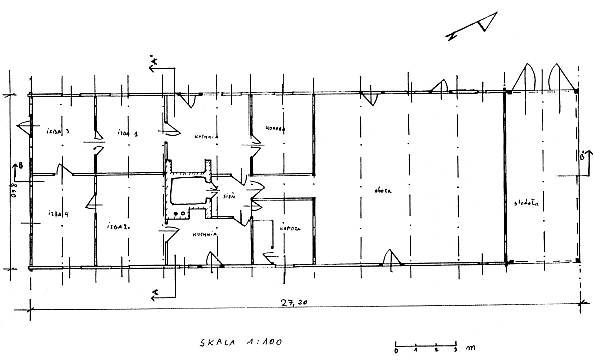
The building is made of pine and oak (ground sill) wood and has two types of structure: a solid beam and post structure, joined at corners by dovetail halvings with protruding log ends and a timber frame structure, which is planked with vertical boards (barn). It has a high double-pitched, rafter-collar beam, straw thatched roof. Residential section, cowshed, and a barn are located under one roof. The residential section has a two-bay and three-axial interior with a centrally located, brick and tile fire system, which includes stoves and two kitchen sections. The building is preserved in good condition..
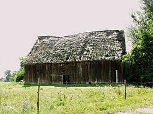 Building no. 21 is a wooden barn, erected ca. 1900. It is made of pine wood and has a timber frame structure, which is reinforced with angle braces and struts and planked with vertical boards. The double-pitched, rafter-collar beam (double collar beams) roof is reinforced with ties and roofed with rye straw. It was built on a rectangular plan and has a central threshing floor and two storage spaces on sides (the interior is partitioned with two low walls). The building is preserved in satisfactory condition.. Building no. 21 is a wooden barn, erected ca. 1900. It is made of pine wood and has a timber frame structure, which is reinforced with angle braces and struts and planked with vertical boards. The double-pitched, rafter-collar beam (double collar beams) roof is reinforced with ties and roofed with rye straw. It was built on a rectangular plan and has a central threshing floor and two storage spaces on sides (the interior is partitioned with two low walls). The building is preserved in satisfactory condition..
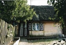
 No. 37 is a wooden house (former school) erected ca. 1900. It faces the flood-bank with the gable; it is located in the central section of the village in a single-building homestead fenced with a picket fence. It directly adjoins the road that runs on top of the flood-bank. The building is made of poplar and oak (ground sill) wood and has a solid beam and post structure, joined at corners by dovetail halvings - boarded. It has a high double-pitched, rafter-collar beam roof, which is reinforced with queen posts and covered with fiberboard. It is only used for housing purposes. The interior has a two-bay and five-axial layout with a hallway (open on both sides) and a fire system, which has been rebuilt and is shifted towards the northern gable wall. The building is preserved in good condition. No. 37 is a wooden house (former school) erected ca. 1900. It faces the flood-bank with the gable; it is located in the central section of the village in a single-building homestead fenced with a picket fence. It directly adjoins the road that runs on top of the flood-bank. The building is made of poplar and oak (ground sill) wood and has a solid beam and post structure, joined at corners by dovetail halvings - boarded. It has a high double-pitched, rafter-collar beam roof, which is reinforced with queen posts and covered with fiberboard. It is only used for housing purposes. The interior has a two-bay and five-axial layout with a hallway (open on both sides) and a fire system, which has been rebuilt and is shifted towards the northern gable wall. The building is preserved in good condition.
 Building no. 39 is a wooden house, erected ca. 1900. It faces the flood-bank with the gable (the residential section located on the southern side) and is located ca. 100 m from it in the central part of the village in a four-building homestead. The homestead includes: a shed (western side), a woodshed (north-eastern side), and a garage (south-western side) and is surrounded with a picket fence. The homestead is made of pine wood and has two types of structure: a corner-notched log structure (residential section and cowshed), joined at corners by dovetail halvings with protruding log ends and a timber frame structure, which was planked with vertical boards (barn). It has a high double-pitched, rafter-collar beam roof, which is reinforced with ties and covered with roofing paper and sheet metal. Residential section, cowshed, and a barn are located under one roof. The residential section has a two-bay and four-axial layout with a centrally located fire system which has a black kitchen located in the middle and a brick kitchen stove, a bread oven, and a smoke room in the chimney. The building is preserved in good condition (BK - Jerzy Szałygin, 1995). Building no. 39 is a wooden house, erected ca. 1900. It faces the flood-bank with the gable (the residential section located on the southern side) and is located ca. 100 m from it in the central part of the village in a four-building homestead. The homestead includes: a shed (western side), a woodshed (north-eastern side), and a garage (south-western side) and is surrounded with a picket fence. The homestead is made of pine wood and has two types of structure: a corner-notched log structure (residential section and cowshed), joined at corners by dovetail halvings with protruding log ends and a timber frame structure, which was planked with vertical boards (barn). It has a high double-pitched, rafter-collar beam roof, which is reinforced with ties and covered with roofing paper and sheet metal. Residential section, cowshed, and a barn are located under one roof. The residential section has a two-bay and four-axial layout with a centrally located fire system which has a black kitchen located in the middle and a brick kitchen stove, a bread oven, and a smoke room in the chimney. The building is preserved in good condition (BK - Jerzy Szałygin, 1995).
 Building no. 47 was built of wood in the first half of the 19th century. It faces the flood-bank with the gable (the residential section located on the southern side) and is located ca. 30 m from it in the central part of the village in a five-building homestead. The homestead includes: two sheds (north-eastern side), a woodshed (eastern side), and a new, unfinished residential and farm building (eastern side) and is surrounded with a picket fence. A cellar is also part of the homestead. The building is made of pine wood and has a corner-notched log structure (residential section and cowshed), joined at corners by dovetail halvings with protruding log ends. It has a high, double-pitched, rafter-collar beam roof, which is reinforced with queen posts and covered with roofing paper and plywood. Originally, the residential section, the cowshed, and the barn were located under one roof. The farm section has been disassembled. The residential section has a two-bay and three-axial layout with a centrally located fire system, which includes: a bread oven and a smokebox in the chimney, tile kitchen stoves - one in the kitchen located on the eastern side and another one in the in the north-western room (BK - Jerzy Szałygin, 1995). Building no. 47 was built of wood in the first half of the 19th century. It faces the flood-bank with the gable (the residential section located on the southern side) and is located ca. 30 m from it in the central part of the village in a five-building homestead. The homestead includes: two sheds (north-eastern side), a woodshed (eastern side), and a new, unfinished residential and farm building (eastern side) and is surrounded with a picket fence. A cellar is also part of the homestead. The building is made of pine wood and has a corner-notched log structure (residential section and cowshed), joined at corners by dovetail halvings with protruding log ends. It has a high, double-pitched, rafter-collar beam roof, which is reinforced with queen posts and covered with roofing paper and plywood. Originally, the residential section, the cowshed, and the barn were located under one roof. The farm section has been disassembled. The residential section has a two-bay and three-axial layout with a centrally located fire system, which includes: a bread oven and a smokebox in the chimney, tile kitchen stoves - one in the kitchen located on the eastern side and another one in the in the north-western room (BK - Jerzy Szałygin, 1995).
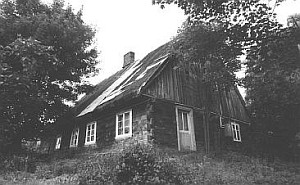
 Building no. 68 was built of wood in the first half of the 19th century. It faces the flood-bank with the ridge (the residential section located on the eastern side) and is located ca. 200 m from it in the western part of the village. The building is part of a four-building homestead that includes: two sheds (southern side) and a new residential building erected in the site of the disassembled farm section (cowshed and barn). It is surrounded with a picket fence. The building is made of pine (ground sill) and poplar; it has a corner-notched log structure with corners connected by dovetail halvings with log ends. It has a high double-pitched, rafter-collar beam, rye straw thatched roof, which is reinforced with queen posts. A porch has been added to the southern wall; it has an entrance to the hallway. The residential section has a two-bay and two and a half-axial layout with a centrally located fire system, which includes: a bread oven and a smokebox in the chimney, tile kitchen stoves - in the north and southern rooms. The walls of the south-eastern room are painted with oil paints and are decorated with rosettes with plant-like motifs - painted with a template. The building is in bad condition - to be taken down. Building no. 68 was built of wood in the first half of the 19th century. It faces the flood-bank with the ridge (the residential section located on the eastern side) and is located ca. 200 m from it in the western part of the village. The building is part of a four-building homestead that includes: two sheds (southern side) and a new residential building erected in the site of the disassembled farm section (cowshed and barn). It is surrounded with a picket fence. The building is made of pine (ground sill) and poplar; it has a corner-notched log structure with corners connected by dovetail halvings with log ends. It has a high double-pitched, rafter-collar beam, rye straw thatched roof, which is reinforced with queen posts. A porch has been added to the southern wall; it has an entrance to the hallway. The residential section has a two-bay and two and a half-axial layout with a centrally located fire system, which includes: a bread oven and a smokebox in the chimney, tile kitchen stoves - in the north and southern rooms. The walls of the south-eastern room are painted with oil paints and are decorated with rosettes with plant-like motifs - painted with a template. The building is in bad condition - to be taken down.
Building no. 70 is a wooden house, erected ca. 1900. It faces the flood-bank with the ridge (the residential section located on the eastern side) and is located ca. 400 m from it in the western section of the village in a single-building homestead, which is surrounded with a picket fence. The building is made of poplar and oak (ground sill) wood and has two types of structure: a corner-notched log structure, joined at corners by dovetail halvings with protruding log ends and a timber frame structure, which was reinforced with angle braces and struts and was planked with vertical boards. It has a high double-pitched, rafter-collar beam, rye straw thatched roof, which is reinforced with queen posts. Residential section, cowshed, and a barn are located under one roof. The residential section has a two-bay and two and a half-axial layout with a centrally located fire system, which includes: a bread oven and a smokebox in the chimney, brick kitchen stoves locate in the southern and northern rooms. The cowshed is partitioned with short walls, which designate animal pens. It has central and crosswise passages. The barn has one threshing floor and one storage space. The building is dilapidated - in poor condition.
 House no. 80 is a masonry building dating from 1920. Its ridge faces the road situated on the flood-bank and is located ca. 100 from it in the western end of the village. It is a five-building homestead and includes: a barn on the western side and three sheds on the remaining sides. It was built of bricks bonded with cement-lime mortar; its residential section was plastered. The elevations are divided by three cornices: plinth, inter-story, and topping. The window and door openings are rimmed with a profiled trim. High walls are covered with a high, double-pitched, rafter-collar beam roof. The structure is made of pine and is reinforced with queen posts; it rests on a wall plate supported by a pointing sill. It is roofed with roofing paper and sheet metal. Brick pinnacles are located on the roof corners and gables. Brick porches with entrances are located in the northern and southern walls of the residential section. The residential interior has a two-bay, three-axial layout with a central fire system, which was rebuilt after WWII. The cowshed has a central passage, which divides the space into three sections; animal pens are located on both sides. The building is preserved in good condition. House no. 80 is a masonry building dating from 1920. Its ridge faces the road situated on the flood-bank and is located ca. 100 from it in the western end of the village. It is a five-building homestead and includes: a barn on the western side and three sheds on the remaining sides. It was built of bricks bonded with cement-lime mortar; its residential section was plastered. The elevations are divided by three cornices: plinth, inter-story, and topping. The window and door openings are rimmed with a profiled trim. High walls are covered with a high, double-pitched, rafter-collar beam roof. The structure is made of pine and is reinforced with queen posts; it rests on a wall plate supported by a pointing sill. It is roofed with roofing paper and sheet metal. Brick pinnacles are located on the roof corners and gables. Brick porches with entrances are located in the northern and southern walls of the residential section. The residential interior has a two-bay, three-axial layout with a central fire system, which was rebuilt after WWII. The cowshed has a central passage, which divides the space into three sections; animal pens are located on both sides. The building is preserved in good condition.
A barn without a number. It was made of wood at the beginning of the 20th century and is located next to the flood-bank in the eastern section of the village. The homestead comprises three buildings: a new house on the eastern side, a cowshed on the southern side, and a barn on the western side. The barn faces the road with the gable. The building is made of pine wood; it has timber frame structure, which is boarded with vertical boards. High walls are covered with a high, double-pitched, rafter-collar beam roof, with rye straw roofing. It is a single-threshing floor and two storage spaces. The barn is in poor condition (especially the roofing).
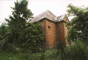
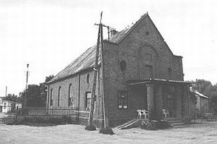
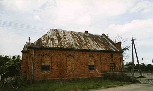
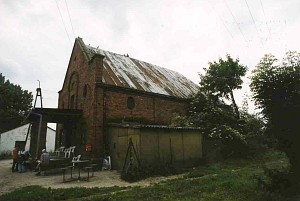 A building without a number - a former Evangelical church erected just before the war in 1939. Practically, it has never been used (one mass was held in the building). It is situated in the central section of the village near the flood-bank on the western side of the village road. Its ridge faces the river and the building is slightly removed from it. The building is made of bricks bonded with cement-lime mortar; the structure rests on high foundation. The building has a high, triple-pitched (on the western side, above the chancel), rafter-collar beam roof with sheet metal roofing. The elevations have not been plastered and retained the natural color of brick. The eastern facade is preceded by a cement pent roof, which is supported by two brick posts. It hides the entrance with high two-sided stairs. The wall is topped with a triangular gable with pinnacles and a centrally located, oval window. The windows in side elevations have been underpinned at the bottom. They are rimmed with brick trims and window sills, which are divided by plinth and topping cornices. The western elevation has an entrance in place of a window. The interior has three sections (originally two). It has a one-bay and three-axial layout and currently houses (starting from the eastern side): a grocery store (established after WWII), storage room, and a hallway (originally vestry). The loft can be reached by wide, stringer type stairs located in the hallway. The building is preserved in good condition. A building without a number - a former Evangelical church erected just before the war in 1939. Practically, it has never been used (one mass was held in the building). It is situated in the central section of the village near the flood-bank on the western side of the village road. Its ridge faces the river and the building is slightly removed from it. The building is made of bricks bonded with cement-lime mortar; the structure rests on high foundation. The building has a high, triple-pitched (on the western side, above the chancel), rafter-collar beam roof with sheet metal roofing. The elevations have not been plastered and retained the natural color of brick. The eastern facade is preceded by a cement pent roof, which is supported by two brick posts. It hides the entrance with high two-sided stairs. The wall is topped with a triangular gable with pinnacles and a centrally located, oval window. The windows in side elevations have been underpinned at the bottom. They are rimmed with brick trims and window sills, which are divided by plinth and topping cornices. The western elevation has an entrance in place of a window. The interior has three sections (originally two). It has a one-bay and three-axial layout and currently houses (starting from the eastern side): a grocery store (established after WWII), storage room, and a hallway (originally vestry). The loft can be reached by wide, stringer type stairs located in the hallway. The building is preserved in good condition.
The cemetery is located in the eastern end of the village on the southern side of the road that runs on the flood-bank. The cemetery had a rectangular layout and is entirely overgrown with bushes and trees. It is devastated with at least six preserved, overturned, cement gravestones. Numerous grave mounds are distinguishable.
The non-existent buildings with monument record cards (currently in KOBiDZ collections) prepared by Wojciech Marchlewski in 1979:
No. 51 - a wooden house, built in the second half of the 19th century.
No. 56 - a wooden house, erected at the beginning of the 20th century.
No. 63 - a wooden house, erected ca. 1890.
No. 66 - a wooden house, erected at the beginning of the 20th century.
No. 69 - a wooden house, erected at the beginning of the 20th century.
No. 72 - a wooden house, erected at the beginning of the 20th century.
Księgi Referendarii Koronnej z drugiej połowy XVIII w., t. II, wyd. A. Keckowa i W. Pałucki, Warszawa 1957;
SGKP, t. XII, 1892, s. 512.
|
)
)