|
gm. Czosnów, pow. nowodworski, woj. mazowieckie

The village was founded by Dutch at the end of the 18th century. Initially, the village was probably part of the village of Markowszczyzna. It comprised only 6 homesteads. The settlers cultivated land, grew fruit, and also raised cattle - the residents were famous for Dutch cheese manufacture. They were also known for their wickerwork. Numerous osiers planted on the fields provided material for these products.
Sady is a linear village located on the southern side of the Vistula between Nowy Kazuń and Stare Grochale with houses situated between the road and the flood-bank on man-made rises (terepy).
The cultural landscape has been partially transformed; it has been best preserved in the north-western section of the settlement. Rises with willows, poplars, and orchards are visible around preserved homesteads. Roads that run to the Kazuń- Śladów highway perpendicularly to the flood-bank are also distinguishable. Only one building characteristic for the Dutch colonization have survived to the present day from four buildings that existed until 1995.
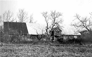
Building no. 15 was built of wood in 1927. It is located in the western part of the village near the flood-bank; it faces it with the ridge. The building is made of poplar wood and has a corner-notched log structure, joined at corners by dovetail halvings with protruding log ends. It is covered with a high double-pitched roof with asbestos tile roofing. A brick porch has been added to the southern side of the building; it is covered with a pent roof. The residential section has a two-bay and two-axial layout with a centrally located chimney and a traditional fire system - two-stove-lid kitchen located in the chimney niche. The cowshed has a single room. The building is preserved in satisfactory condition.
Non-existent objects:
No 14 - wooden house erected in 1927; burned down in 1991.
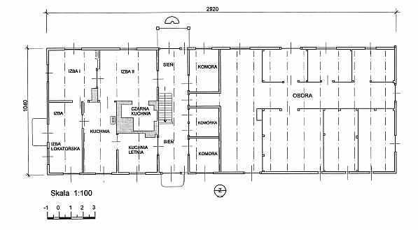
 No. 18 - wooden house erected in 1920; taken down in 1991. Building no. 18 was the most interesting object among the houses in Sady and requires an elaborated description. The building was erected in 1853. It not only functioned as a residence and farm building but also had religious functions - two rooms, located in the loft were used by faithful to say prayers (?) The house was situated near the flood-bank and faced it with the gable; the residential section was located on the southern side. The building was situated on an artificial rise and was surrounded from three sides with willows and bushes (lilac, among others). It rested on a stone foundation and oak ground sills. The pine walls had a beam and post structure joined at corners with dovetail halvings with log ends. It had a high rafter-collar beam roof, reinforced with queen-posts and roofed with sheet metal. A dormer was situated on the eastern side; it had a double-pitched roof. The main entrance to the building was located on the western side in a porch supported by two posts. Residential and farm (cowshed) sections were located under one roof. The building was distinguishable because of its extraordinary decoration. Every element - windows, doors, shutters, ceiling joists, eave cornices, and the porch - was exquisitely carved. The interior had a fire system with a wide, bottle-shaped chimney; tile stoves, heaters, kitchen stoves, a smokebox, and a bread oven were arranged around its structure. This type of system is unique for the Dutch houses in Mazowsze. The residential interior was divided into ten rooms (originally nine - the south-western room was partitioned only after WWII). The entrance to the building led through an entrance hall, which was open on both sides. Main residential spaces stretched behind the chimney; they were heated by a tile stove connected to the wide chimney by a special duct - rękaw. The farm section was divided into four rooms. A space for fodder preparation was located near the chamber wall; it also included a well. A passage ran through the middle with stalls for horses, cows, and pigs located on its sides.
The building was sporadically used starting from beginning of 1990s. Being devastated by the local vandals, it was gradually destroyed; it was taken down in 1995. (BK - Jerzy Szałygin, 1995). (BK
- Jerzy Szałygin, 1995). No. 18 - wooden house erected in 1920; taken down in 1991. Building no. 18 was the most interesting object among the houses in Sady and requires an elaborated description. The building was erected in 1853. It not only functioned as a residence and farm building but also had religious functions - two rooms, located in the loft were used by faithful to say prayers (?) The house was situated near the flood-bank and faced it with the gable; the residential section was located on the southern side. The building was situated on an artificial rise and was surrounded from three sides with willows and bushes (lilac, among others). It rested on a stone foundation and oak ground sills. The pine walls had a beam and post structure joined at corners with dovetail halvings with log ends. It had a high rafter-collar beam roof, reinforced with queen-posts and roofed with sheet metal. A dormer was situated on the eastern side; it had a double-pitched roof. The main entrance to the building was located on the western side in a porch supported by two posts. Residential and farm (cowshed) sections were located under one roof. The building was distinguishable because of its extraordinary decoration. Every element - windows, doors, shutters, ceiling joists, eave cornices, and the porch - was exquisitely carved. The interior had a fire system with a wide, bottle-shaped chimney; tile stoves, heaters, kitchen stoves, a smokebox, and a bread oven were arranged around its structure. This type of system is unique for the Dutch houses in Mazowsze. The residential interior was divided into ten rooms (originally nine - the south-western room was partitioned only after WWII). The entrance to the building led through an entrance hall, which was open on both sides. Main residential spaces stretched behind the chimney; they were heated by a tile stove connected to the wide chimney by a special duct - rękaw. The farm section was divided into four rooms. A space for fodder preparation was located near the chamber wall; it also included a well. A passage ran through the middle with stalls for horses, cows, and pigs located on its sides.
The building was sporadically used starting from beginning of 1990s. Being devastated by the local vandals, it was gradually destroyed; it was taken down in 1995. (BK - Jerzy Szałygin, 1995). (BK
- Jerzy Szałygin, 1995).
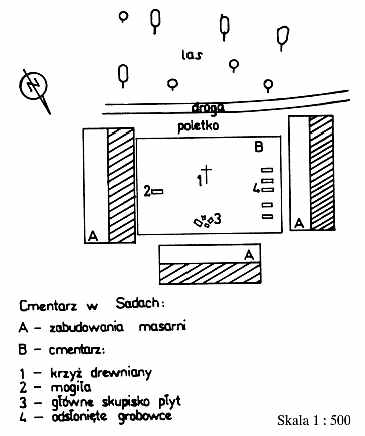
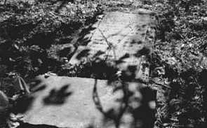 The cemetery is located in the western part of the village on premises of a meat processing plant. The borders of the cemetery are marked off by the surrounding buildings. Currently the site occupies ca. 800 m2 and has 20-30 plots. This number is difficult to estimate because the site is extensively overgrown with trees and bushes and no gravestones are present. The number of plots was estimated based on the amount of uncovered grave foundations, whose symmetrical arrangement suggests the original location of the graves. Seven partial and two whole gravestones have survived (upturned, one buried in the ground). The cemetery also has a grave with a metal cross - probably from the post-war period. A wooden, ca. 4 m high cross is located in the center of the site. Only a few dates can be deciphered from barely legible inscriptions: "1800", "1821", and "1838". The cemetery is located in the western part of the village on premises of a meat processing plant. The borders of the cemetery are marked off by the surrounding buildings. Currently the site occupies ca. 800 m2 and has 20-30 plots. This number is difficult to estimate because the site is extensively overgrown with trees and bushes and no gravestones are present. The number of plots was estimated based on the amount of uncovered grave foundations, whose symmetrical arrangement suggests the original location of the graves. Seven partial and two whole gravestones have survived (upturned, one buried in the ground). The cemetery also has a grave with a metal cross - probably from the post-war period. A wooden, ca. 4 m high cross is located in the center of the site. Only a few dates can be deciphered from barely legible inscriptions: "1800", "1821", and "1838".
B. Andrzejewska, Inwentaryzacja architektoniczna domu ze wsi Sady 18,Warszawa 1992, w zbiorach archiwum SOZ Warszawa;
T. Swat, Mennonici na Mazowszu.
|
)
)
)