|
gm. Słubice, pow. płocki, woj. mazowieckie
The village was founded by the Dutch settlers in 1787 under agreement with Adam Lasocki. The colonists were given 30 morga of land. They were also granted a wilkierz (collection of laws) comprising 41 sections, which specified the rules for community self-government: "The residents are to elect a sołtys and two jurors, who are to keep the village lawful and just and are to settle disputes and arguments. They are also to decide all cases and suits, except for criminal and serious matters which are to be settled by the state courts". And later: "No resident or a stranger may hand over the case to the Higher Authority before the case has been heard by a sołtys and jurors and their verdict has been given. All, who act against this rule will pay a fine of 5 Marks". In 1798, a German-Evangelical elementary school was established; 22 students attended classes. By 1889, the village had 32 houses and 292 residents. Its area equaled 778 morga of land suitable for wheat. The residents grew sugar beets, osiers, produced Dutch cheeses, and above all, grew fruit (at that time, the orchards brought on average 300 rubles in revenue annually per one settlement).
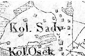
Sady is a linear and colonial village located to the south of Wiączemin Polski and Wiączemin Nowy, to the west of the Wymyśle Polski-Świniary road. It is separated from it by a deep drainage ditch.
The village is very well preserved - trees planted around homesteads and on fields, drainage canals, wattle fences, and above all, traditional homesteads located on man-made rises. The homesteads are removed from one another (ca. 200-500 m) and are dispersed among fields. The village has the oldest preserved building related to the Dutch colonization in Mazowsze - originally, Mennonite, then Evangelical - church. The building dates from 1806; it was mentioned in a document from 1809.
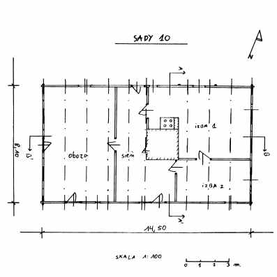 Building no. 10 is a wooden house built in the mid-19th century. It is located in the central section of the village along an east-west line on a very high, ca. 2.5 m, artificial rise (another rise is situated approx. 100 m from it in the north-western direction; a building, which used to be located on it, no longer exists). A flower and vegetable garden is located on the southern side of the building; it is sectioned off with a picked fence. The building is made of poplar and oak (ground sill) wood and has a corner-notched log structure, joined at corners by dovetail halvings - boarded with vertical planks. It is covered with a double-pitched, rafter-collar beam roof with roofing paper and fiberboard. The entrance to the cowshed is located on the southern side; the door is topped with a segment arch. The residential interior has a one and a half-bay and two-axial layout with a centrally located chimney and a traditional fire system with a black kitchen at the base, a bread oven, a tile stove, a smokebox in the chimney, and a heater. The hallway has a brick heater. The cowshed has a single room. The building is preserved in good condition (BK - Jerzy Szałygin, 1999).. Building no. 10 is a wooden house built in the mid-19th century. It is located in the central section of the village along an east-west line on a very high, ca. 2.5 m, artificial rise (another rise is situated approx. 100 m from it in the north-western direction; a building, which used to be located on it, no longer exists). A flower and vegetable garden is located on the southern side of the building; it is sectioned off with a picked fence. The building is made of poplar and oak (ground sill) wood and has a corner-notched log structure, joined at corners by dovetail halvings - boarded with vertical planks. It is covered with a double-pitched, rafter-collar beam roof with roofing paper and fiberboard. The entrance to the cowshed is located on the southern side; the door is topped with a segment arch. The residential interior has a one and a half-bay and two-axial layout with a centrally located chimney and a traditional fire system with a black kitchen at the base, a bread oven, a tile stove, a smokebox in the chimney, and a heater. The hallway has a brick heater. The cowshed has a single room. The building is preserved in good condition (BK - Jerzy Szałygin, 1999)..
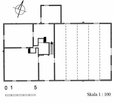
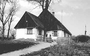
 Object no. 15 is a wooden building - a former Mennonite built in 1806 (inscription "praise 1806 the Lord" has been placed on the top plate). It is located in the central section of the village along an east-west line on a high, ca. 1.5 m high, artificial rise. Before, WWII the building served as an Evangelical church (after the war its paraphernalia have been transferred to the church in Wiączemin Polski). A small cowshed is situated across from it on the western side. Wide concrete stairs are located on the southern side of the building; originally they led to the prayer room. The homestead is partially surrounded by a picket fence. The cemetery adjoins the building from the southern side.
The building is made of pine wood and has a corner-notched log structure, joined at corners by dovetail halvings with log ends. The walls of the former prayer room are 2.5 m high and are stabilized by vertical braces. The structure is covered with a high, double-pitched, rafter-collar beam roof with roofing paper and fiberboard. The entrance to the prayer room leads through a hallway from the southern side or directly from the eastern side. Originally, the prayer room had a barrel vaulted ceiling (structure disassembled). The residential interior, which originally served as a teacher's apartment and a school, has a two-bay and two-axial layout with a centrally located chimney and a traditional fire system with a black kitchen at the base, a bread oven, a tile stove, two kitchen stoves, and a heater. A smokebox is located in the chimney. The prayer room has a single-room layout and currently serves as a cowshed. The building is in poor condition - the former prayer room is to be taken down because it is seriously damaged. This building is the most precious object associated with the Dutch colonization in Mazowsze. Object no. 15 is a wooden building - a former Mennonite built in 1806 (inscription "praise 1806 the Lord" has been placed on the top plate). It is located in the central section of the village along an east-west line on a high, ca. 1.5 m high, artificial rise. Before, WWII the building served as an Evangelical church (after the war its paraphernalia have been transferred to the church in Wiączemin Polski). A small cowshed is situated across from it on the western side. Wide concrete stairs are located on the southern side of the building; originally they led to the prayer room. The homestead is partially surrounded by a picket fence. The cemetery adjoins the building from the southern side.
The building is made of pine wood and has a corner-notched log structure, joined at corners by dovetail halvings with log ends. The walls of the former prayer room are 2.5 m high and are stabilized by vertical braces. The structure is covered with a high, double-pitched, rafter-collar beam roof with roofing paper and fiberboard. The entrance to the prayer room leads through a hallway from the southern side or directly from the eastern side. Originally, the prayer room had a barrel vaulted ceiling (structure disassembled). The residential interior, which originally served as a teacher's apartment and a school, has a two-bay and two-axial layout with a centrally located chimney and a traditional fire system with a black kitchen at the base, a bread oven, a tile stove, two kitchen stoves, and a heater. A smokebox is located in the chimney. The prayer room has a single-room layout and currently serves as a cowshed. The building is in poor condition - the former prayer room is to be taken down because it is seriously damaged. This building is the most precious object associated with the Dutch colonization in Mazowsze.
 Building no. 15 is a small cowshed built in 1915 of pine wood; it has a corner-notched log structure, joined at corners by dovetail halvings with protruding log ends. It is covered with a low (1.6 m) double-pitched, rafter roof with fiberboard roofing. It is a single-room building; it is in poor condition.. Building no. 15 is a small cowshed built in 1915 of pine wood; it has a corner-notched log structure, joined at corners by dovetail halvings with protruding log ends. It is covered with a low (1.6 m) double-pitched, rafter roof with fiberboard roofing. It is a single-room building; it is in poor condition..
 Building no. 17 is wooden house erected at the beginning of the 19th century. It is located in the central section of the village approx. 200 m from the road to Wiączemin. The homestead can be reached by a paved road that runs between drainage ponds. The building is made of pine and oak (ground sill) wood and has a corner-notched log structure, joined at corners by dovetail halvings with log ends. It is covered with a double-pitched, rafter-collar beam roof reinforced with ties and covered with roofing paper and fiberboard. The roof structure of the cowshed rests on a summer beam. A residential section and remains of a cowshed are located under one roof. Originally, the cowshed was longer. A timber frame, boarded barn was located behind the cowshed - it was taken down after WWII. The residential section has a two-bay and four-axial interior with a centrally located chimney and a fire system, which includes a black kitchen, heaters, two kitchens stoves, and a bread oven. A residential annex for "the elders" has been added to the southern gable of the house. A cellar has been built under a part of this section - entrance on the eastern side. The cowshed has a single room. The building is preserved in satisfactory condition (BK - all record cards of the above buildings - Jerzy Szałygin, 1999). Building no. 17 is wooden house erected at the beginning of the 19th century. It is located in the central section of the village approx. 200 m from the road to Wiączemin. The homestead can be reached by a paved road that runs between drainage ponds. The building is made of pine and oak (ground sill) wood and has a corner-notched log structure, joined at corners by dovetail halvings with log ends. It is covered with a double-pitched, rafter-collar beam roof reinforced with ties and covered with roofing paper and fiberboard. The roof structure of the cowshed rests on a summer beam. A residential section and remains of a cowshed are located under one roof. Originally, the cowshed was longer. A timber frame, boarded barn was located behind the cowshed - it was taken down after WWII. The residential section has a two-bay and four-axial interior with a centrally located chimney and a fire system, which includes a black kitchen, heaters, two kitchens stoves, and a bread oven. A residential annex for "the elders" has been added to the southern gable of the house. A cellar has been built under a part of this section - entrance on the eastern side. The cowshed has a single room. The building is preserved in satisfactory condition (BK - all record cards of the above buildings - Jerzy Szałygin, 1999).

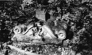
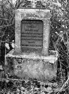
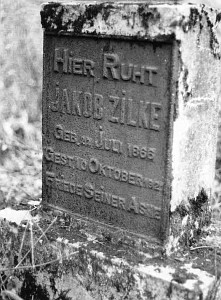
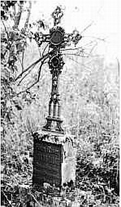 The cemetery is located in the central part of the village; it borders the former church. The cemetery has a rectangular layout and is overgrown with bushes; it is devastated but 10 gravestones have survived. They are made mainly of sandstone with inscriptions in German language and majority of them dates from the 1920s and 1930s. Some of them have shattered medallions with photographs of the deceased. Several gravestone bases are entirely destroyed; cast-iron crosses are overturned. Legible gravestones belong to: Michael Krüger, deceased on January6, 1937 r., Julian Kriger, deceased on April 24, 1926 r. and the Brokop family: Amanda, deceased on June 11, 1881, Berta, deceased on October 31, 1885, and Wilhelm, deceased on January 31, 1904, among others..
AWP, Akta notarialne kancelarii notarialnej w Gostyninie F. Czajkowskiego, nr 270, 1;
W. Marchlewski, Mennonici w Polsce...;
SGKP, t. X, 1889, s. 206.
|
)
)
)
)