|
gm. Dąbie, pow. kolski, woj. wielkopolskie
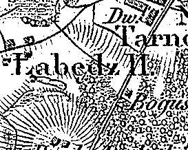
Łabędź was a gentry village (owned by Rupret Dunin) colonized by the Dutch settlers ca. 1790. In 1790, it had 6 houses. In 1884, the village had 7 houses and 70 residents. Łabędź is a small linear village located north of Dąbie and west of the road to Kłodawa. Homesteads are located on both sides of the road running along the northeast-southwest line. Farmland descends in the northwestern direction, towards ponds and canals. The cultural landscape characteristic of the Dutch colonization is in good condition. Traditional field layout, homestead location, ponds collecting the excess of ground water, and draining canals have survived. No examples of traditional architecture associated with the settlers are present.
J. Goldberg, Osadnictwo ...
SGKP, t.V., 1884, s 558.
|
)