|
gm. Wyszogród, pow. płocki, woj. mazowieckie
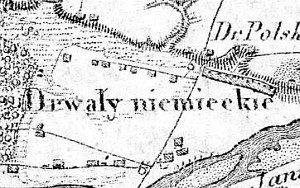
The first mention of the village of Drwały dates from 1303. In the 16th century the village was a part of the church estate. The Dutch colonists settled within the village limits at the end of the 18th century on the periodically flooded wasteland by the Vistula river. The old section of the village was called Drwały Polskie (until 1830) and the new one - Drwały Niemieckie. By 1827, the village had 43 houses and 336 residents. In 1881, the village had 42 houses, an Evangelical school, a wind mill and a state inn.
Drwały is a linear village located on the northern side of the Vistula and to the south of the Zakroczym - Płock road. The homesteads are situated along an east-west line.
The cultural landscape of the village is well preserved with visible planted vegetation (willows and poplars), a field layout, drainage canals, and man-made rises, on which the settlers built their homesteads. No objects representative for the Dutch architecture have survived.
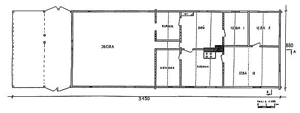 The last remaining building (from 1890) characteristic for this type of settlement was taken down in 1999. The building no. 45 was located in the eastern section of the village and was parallel to the river; its residential section faced the east. It included a residential section, a cowshed (both had a corner-notched log construction connected at quoins by the dovetail joints with protruding log ends), and a barn (timber frame construction) under one roof. High (2.7 m) walls were covered with a high (3.4 m) double-pitched, rye straw thatched roof. The entire structure of the building was made of poplar wood. The residential section had a two-bay and four-axial interior with a centrally located fire system. The cowshed had one room; the barn had one threshing floor and one storage space (BK- Jerzy Szałygin, 1994). The last remaining building (from 1890) characteristic for this type of settlement was taken down in 1999. The building no. 45 was located in the eastern section of the village and was parallel to the river; its residential section faced the east. It included a residential section, a cowshed (both had a corner-notched log construction connected at quoins by the dovetail joints with protruding log ends), and a barn (timber frame construction) under one roof. High (2.7 m) walls were covered with a high (3.4 m) double-pitched, rye straw thatched roof. The entire structure of the building was made of poplar wood. The residential section had a two-bay and four-axial interior with a centrally located fire system. The cowshed had one room; the barn had one threshing floor and one storage space (BK- Jerzy Szałygin, 1994).
The remains of a cemetery are located in the western section of the village, on the southern side of the village road, which runs along the flood-bank. The site is situated on an artificial rise; it is overgrown with trees and bushes, which form a rectangular cluster. No gravestones have survived to the present day.
SGKP, T. II, 1881, s. 175.
|
)
)