|
gm. Stegna, pow. nowodworski, woj. pomorskie
Until 1945 Gross Brunau, Klein Brunau, Brunau - (Endersch, Schrötter)
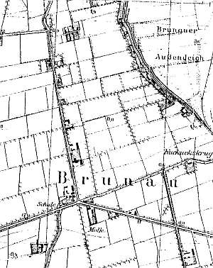
The village was founded in 1356. In its original form, it probably included a section located by the flood bank. Later, it was developed by Dutch colonist who erected their homesteads on terpy and by causeways. The current village includes former Brunau, Brunauer Sand, and Jankendorf and also single-homestead inns - Dancker Krug and Kukuks Krug Between 1920 and 1930, colonial houses were constructed in Brunauer Sand.
In 1820, the village together with Altschloss had 471 residents, including 6 Mennonites. Village layout - flood bank linear village on the southern side of the Elbląg Vistula and a linear village in a north-south axis. Formerly, the village had 4 large Dutch farms and 2 smaller ones located in the colony at the intersection of canals, that is, in the place where the homesteads that belonged to the former villages of Voytea, Żuławka, and Niedźwiedzica were located. A large estate was sectioned off from a large farm situated by the intersection of the roads to Bronowo, Wiśniówki, and Żuławki; later, a dairy was established below. The cultural landscape developed primarily at the beginning of the 20th century is in good condition and includes 20 wooden buildings dating from the 1st quarter of the 20th century (most of them have been bricked), ca. 5 Dutch homesteads without barns, brick buildings from the beginning of the 20th century (e.g. a school with regional elements), a field layout, and a network of draining canals. The southwestern section of the village has been transformed by buildings of the former state farm. The village has an old Dutch dairy (severely transformed) located in its southern section.
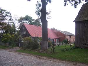 No. 1 is an old Dutch homestead of the longitudinal type
located in the southern section of the village on the eastern side of the
road, facing it with its gable. It includes a house and a 1.5-storey
cowshed (transformed) separated from the house by a fire wall. A barn has
been taken down. The house was erected in the 4th quarter of the 19th
century. It is made of wood and plastered. Its gable is boarded
vertically. It has sheet metal roofing; the elevations have been
transformed. No. 1 is an old Dutch homestead of the longitudinal type
located in the southern section of the village on the eastern side of the
road, facing it with its gable. It includes a house and a 1.5-storey
cowshed (transformed) separated from the house by a fire wall. A barn has
been taken down. The house was erected in the 4th quarter of the 19th
century. It is made of wood and plastered. Its gable is boarded
vertically. It has sheet metal roofing; the elevations have been
transformed.
A wooden coach house/granary is located in the
southwestern corner of the yard.
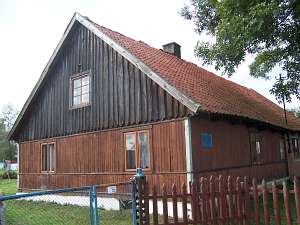 No. 38 is a Dutch homestead and
includes a house and a cowshed covered by a common roof (a barn has been
demolished). It is located in the southern section of the village, on the
southern side of the local road, facing it with its ridge. The homestead
dates from the beginning of the 20th century. The house has a
corner-notched vertically boarded log structure with quoins covered by
boards, a vertically boarded gable, and a tile roof. The gable elevation
has 2 axes with a 1-axial gable. The northern elevation has 2 axes.
The building has been transformed. No. 38 is a Dutch homestead and
includes a house and a cowshed covered by a common roof (a barn has been
demolished). It is located in the southern section of the village, on the
southern side of the local road, facing it with its ridge. The homestead
dates from the beginning of the 20th century. The house has a
corner-notched vertically boarded log structure with quoins covered by
boards, a vertically boarded gable, and a tile roof. The gable elevation
has 2 axes with a 1-axial gable. The northern elevation has 2 axes.
The building has been transformed.
Lipińska, t. III, poz. 233, AG IV.
|
)