|
gm. Szczawin Kościelny, pow. gostyniński, woj. mazowieckie
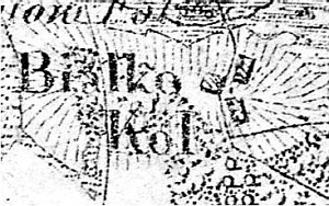
The village was founded ca. 1805. It had an Evangelical school. In 1900, it had 11 houses, 79 residents and 179 morga of land.
Białka is a linear village located to the west of the Żychlin-Gąbin road on the southern bank of the Przysowa river along an east-west line, with homesteads situated on both sides of the road that runs through the village. The village spreads on a rise with cultivated fields and pastures located below the line of buildings.
The cultural landscape associated with the Dutch colonization is well preserved - it has a detectable field layout, with willows planted on the balks, drainage canals and ponds collecting the excess water, and poplar and willow trees planted among the homesteads.
The homesteads are modern with an absence of historical objects associated with the colonists.
Dzieje Gostynina i Ziemi Gostynińskiej, red. M. Chudzyński, Warszawa 1990; SGKP, t. XV/I, 1900, s. 124.
|
)