|
gm. Gronowo Elbląskie, pow. elbląski, woj. warmińsko - mazurskie
Until 1945 Grunau TK (Gotha, Endersch, Schrőtter)
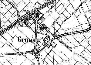
The village was mentioned in 1411 and was granted the rights for the second time in 1414 by the commander Herman Gans. It is probable that at that time, two nearby villages of Gross and Klein Winkelsdorf were incorporated into Gronowo Elbląskie. The village had 44 Chełmno włóksa. The sources from 1565 mentioned an inn located in the village. In the 2nd quarter of the 17th century, Gronowo was owned by a Elbląg burgher from Delft, Izaak Spiring. Until the completion of the railroad from Berlin to Kaliningrad ca. 1850, Gronowo was a typical agricultural village. It included Dutch homesteads arranged in the colonial, single-homestead layout. At the end of the 18th century, the village had 32 homesteads, including 17th and 18th century arcaded houses, which were taken down at the beginning of the 20th century. At the time, the village had 79 włókas and 35 houses. The sources from 1776 mentioned the following Mennonite surnames: Frantz, Froes, Jantzen, Cornelius, Nickel, Puls, Penner, Sammert, Sterling, and Unger. In 1820, there were 63 Mennonites among 247 residents. The petition from 1868 was signed by Dietrich Allert, Peter Bestvater, Jantzen, Quiring, Eduard Regier, and Schmidvol. An increased importance of the village associated with the construction of the railroad largely contributed to changes in the village architecture. At the end of the 19th century, the residents began to build large brick houses in eclectic or modern style. A small settlement associated with the railroad was established by the tracks in the northern section of the village. In the 2nd half of the 19th century, the village acreage equalled 79 włókas. There were 18 homesteads, 35 houses, and 370 residents, including 65 Mennonites. Since 1973, the village has been a seat of the district authorities. The original spatial layout was transformed in the 2nd half of the 19th and beginning of the 20th centuries. The village has a multi-street layout; remains of several Dutch homesteads have survived in its southern section. The cultural landscape includes: buildings from the 19th and 20th centuries, including the railway station with some elements of the regional style, houses of the manor-house type located at Świerkowa 2, Żuławska 1, and Świerkowa 3, wooden buildings with rich fretwork at Żuławska 7, Kolejowa 1, buildings along Łączności street, a school, and a wooden steem mill .
There are no buildings directly associated with the Dutch colonization.
SGKP, t.II, s. 854; Schmid, s. 67, Mamuszka, s. 110-111, Lipińska, t. III, poz. 79; AG BF, MP
|
)