|
gm. Elbląg, pow. elbląski, woj. warmińsko - mazurskie
Until 1945 Ellerwald Vierte Trift TK (Endersch, Schrőtter), Knűppeltrift
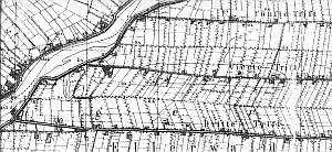
In the Teutonic Knight period, the area of the present-day villages of Adamowo, Kazimierzowo, Janowo, Władysławowo, and Helenowo was covered by marshes, which after digging the Kanał Jagielloński in 1495 were converted into meadows that belonged to Stare Miasto. The development of the meadows began in 1563 when 4 causeways were built; the areas adjacent to these causeways reflected the ownership structure of Stare Miasto in Elbląg. Four hundred thirty five plots were allocated, which corresponded to each tenement house in the town. In order to develop area, the burghers introduced Dutch settlers. The Mennonites who lived in the area belonged to the Ellerwald-Elbing community. In 1776, the following Mennonite surnames were recorded in the Ellerwald villages: Barg, von Bergen, Block, Brand, Brandy, Dircksen, Dick, Sens, Essau, von Riesen, Guenther, Harm, Hiebert, Isaac, Jantzen, Kieler, Kroacker, Loewen, Martens, Neufeldt, Penner, Rempel, Sawatsky, Thiessen, Thimm, Toews, Weis, Wieb, Wiebe, Wiele, Wiens, and Wilmp. In 1921, the area was inhabited by 736 Mennonites. In 1820, in Janowo, there were 272 residents, including 69 were Mennonites. At the beginning of the 20th century, the village had 582 ha and 238 residents. Village layout - single homestead village on terpy and marsh row village - homesteads mainly located on the southern side of the causeway. The cultural landscape is in decline. In 1986, out of 47 original homesteads, 31 still existed; currently, there are only 10 homesteads. One of the streets was modified to meet the standard of a national road; this project changed the proportions of other roads. The field layout and system of draining canals with old willows along the banks are detectable.
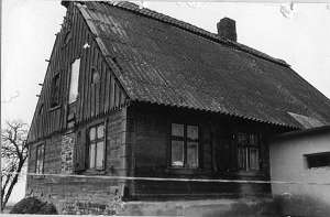  No. 5 is a house from a Dutch homestead of the longitudinal
type situated on a terpa, on the northern side of the road, facing it with
its ridge. It dates from the first quarter of the 19th century. The
building has a corner-notched log structure with quoins covered by boards
imitating rustication, a half-timbered, vertically boarded gable, and a
rafter - collar beam roof structure resting on a protruding top plate. The
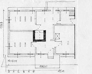
interior has a two-bay layout with similar bays, a black kitchen located
in the southern bay enclosed from 3 sides by a hallway, which separates a
large "parents' room" from a narrow utility room. The hallway has a
staircase and a passage to a cowshed. The livestock buildings and porches
have been taken down. No. 5 is a house from a Dutch homestead of the longitudinal
type situated on a terpa, on the northern side of the road, facing it with
its ridge. It dates from the first quarter of the 19th century. The
building has a corner-notched log structure with quoins covered by boards
imitating rustication, a half-timbered, vertically boarded gable, and a
rafter - collar beam roof structure resting on a protruding top plate. The
interior has a two-bay layout with similar bays, a black kitchen located
in the southern bay enclosed from 3 sides by a hallway, which separates a
large "parents' room" from a narrow utility room. The hallway has a
staircase and a passage to a cowshed. The livestock buildings and porches
have been taken down.
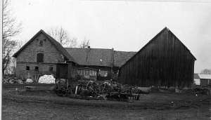 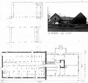 No. 22 is a Dutch homestead of the angular
type situated in the western section of the village, on the southern side
of the road, facing it with its gable. The house was built at the end of
the 19th century. It has a corner-notched structure with quoins covered by
boards imitating Tuscan pilaster, a half-timbered pointing sill, a
vertically boarded gable, a stone/brick concreted foundation, and a queen
post - purlin roof structure. The interior has a two-bay layout with
similar bays, a centrally located black kitchen, and a bipartite, L-shaped
hallway, which separates the residential section from the farming section.
There is row of 5 doors closing the corridor to the cowshed, a staircase,
and utility rooms. The gable elevation has 3 axes, a two-level gable with
4 axes in the lower section, two windows enclosed by quarter circular
small windows, and a semicircular small window above. There is a grid in
the finial between wind ties and a pazdur. The frontal elevation has 6
axes with an entrance in the 3 axis from the north. The homestead includes
a 1.5-story, brick/wooden cowshed dating from the end of the 19th century
with remains of a loading ramp at the mezzanine level and a half-timbered
barn with two threshing floors with braces and struts reinforcing the
structure. No. 22 is a Dutch homestead of the angular
type situated in the western section of the village, on the southern side
of the road, facing it with its gable. The house was built at the end of
the 19th century. It has a corner-notched structure with quoins covered by
boards imitating Tuscan pilaster, a half-timbered pointing sill, a
vertically boarded gable, a stone/brick concreted foundation, and a queen
post - purlin roof structure. The interior has a two-bay layout with
similar bays, a centrally located black kitchen, and a bipartite, L-shaped
hallway, which separates the residential section from the farming section.
There is row of 5 doors closing the corridor to the cowshed, a staircase,
and utility rooms. The gable elevation has 3 axes, a two-level gable with
4 axes in the lower section, two windows enclosed by quarter circular
small windows, and a semicircular small window above. There is a grid in
the finial between wind ties and a pazdur. The frontal elevation has 6
axes with an entrance in the 3 axis from the north. The homestead includes
a 1.5-story, brick/wooden cowshed dating from the end of the 19th century
with remains of a loading ramp at the mezzanine level and a half-timbered
barn with two threshing floors with braces and struts reinforcing the
structure.
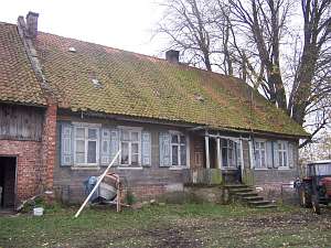 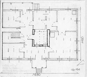 No. 25 is a Dutch homestead of the angular type
located in the western side of the village, on a terpa, by the Nogat flood
bank, facing the causeway road with its ridge. The residential building
was erected in 1870s. It has a corner-notched log structure with quoins
covered by boards imitating Tuscan pilaster, a stone/brick foundation, a
queen post - purlin roof structure with braces, a high roof with a small
attic room (with a pent roof) located in the western slope, a vertically
boarded gable, a wooden, hipped roof arcade on the northeastern side, and
a wooden porch decorated with fretwork in the western elevation. The
interior has a two-bay layout with uneven bays with the large room in the
southwestern corner, a black kitchen in the large room bay, a Z-shaped
hallway with a row of 5 doors leading to the cowshed corridor, utility
rooms, and a staircase. The gable elevation has 3 axes and a 4-axial gable
with two wide windows enclosed by two small skylights with segmented
arches and a small square window above. The frontal elevation has 7 axes
and a centrally located entrance. A cowshed and a barn have been
demolished. No. 25 is a Dutch homestead of the angular type
located in the western side of the village, on a terpa, by the Nogat flood
bank, facing the causeway road with its ridge. The residential building
was erected in 1870s. It has a corner-notched log structure with quoins
covered by boards imitating Tuscan pilaster, a stone/brick foundation, a
queen post - purlin roof structure with braces, a high roof with a small
attic room (with a pent roof) located in the western slope, a vertically
boarded gable, a wooden, hipped roof arcade on the northeastern side, and
a wooden porch decorated with fretwork in the western elevation. The
interior has a two-bay layout with uneven bays with the large room in the
southwestern corner, a black kitchen in the large room bay, a Z-shaped
hallway with a row of 5 doors leading to the cowshed corridor, utility
rooms, and a staircase. The gable elevation has 3 axes and a 4-axial gable
with two wide windows enclosed by two small skylights with segmented
arches and a small square window above. The frontal elevation has 7 axes
and a centrally located entrance. A cowshed and a barn have been
demolished.
Kerstan, s. 199 - 209; ML, t. I, s. 548 - 550; Piątkowski; Lipińska, t. III, poz. 60; AG, BF
|
)