|
gm. Gronowo Elbląskie, pow. elbląski, woj. warmińsko - mazurskie
Until 1945 roku Fichthorst TP, Neukirchenniederung (Neukirch - Endersch), Fichthorst, Fridrichsberg, (Schrötter)
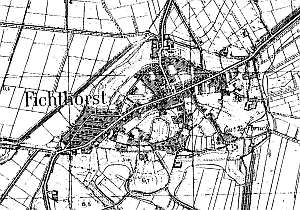
The village was formed from 4 original settlements - Neukirchenniederung (Neukirch until the end of the 19th century), Fichthorst, Friedrichsberg, and Neuhof.
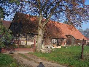
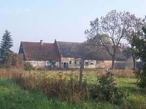
Jegłownik was established in 1595 in a former forest. Initially, it consisted of dispersed settlements, with Kościelisko being the largest. With time, these settlements formed a single village - an Olęder (Dutch) settlement. In 1641, the residents erected a church and established a cemetery. At the time, the current Długa street constituted the axis of the village. The western section of Jegłownik includes the former settlement of Fichthorst and Fridrichsberg located on the southern side of the road to Malbork. The village was expanded after the neighboring forests had been cleared in 1799/1800 and 124 plots were allocated for tenant farms. A windmill was built on a hill at the southern end of the village. The Torfbruch estate (southern section of the current Gronowska street)was established in the 2nd half of the 19th century after a peat lake was drained. . In 1820, the village of Fichthorst had 402 residents, including 5 Mennonites. Village layout - multi-street village; western section is densely built up; buildings are located on both sides of the Elbląg - Malbork road and along curved side streets in the southern and northern sections of the village. An old Lutheran cemetery and a parish church are located in the northeastern section of the village. The cultural landscape of the village is in good condition with a half-timbered parish church surrounded by a cemetery located in the village center, homestead layouts, fragments of wooden buildings, well preserved masonry buildings from the beginning of the 20th century (usually small detached houses of minor gentry or craftsmen, 20th century colonial houses, and several villas), 7 Dutch homesteads of the longitudinal type, and a cowshed connected to a barn with a gable arcade. The windmill has not survived.
 A building at Długa 22 is a Dutch homestead of the
longitudinal type situated on the northern side of the street, facing it
with a ridge. It probably dates from the end of the 19th century. The
buildings have been modified and bricked and are covered with a common
roof (asbestos tiles) with a ridge of the same height. A building at Długa 22 is a Dutch homestead of the
longitudinal type situated on the northern side of the street, facing it
with a ridge. It probably dates from the end of the 19th century. The
buildings have been modified and bricked and are covered with a common
roof (asbestos tiles) with a ridge of the same height.
 A building
at Malborska 26 is a Dutch homestead of the longitudinal type situated on
the northern side of the road, facing it with its ridge. It has a ceramic
roof of a constant height. The residential section is separated from the
rest with a low fire wall. The building dates from mid 1800s and was
rebuilt at the beginning of the 20th century. It has a corner-notched log
structure (plastered), a boarded gable, a rafter roof structure, two-bay
layout with a centrally located black kitchen. The gable elevation has 2
axes and a single-axial gable. The frontal elevation has 3 axes with an
entrance in the 3 axis from the west. The cowshed has been modified; the
barn was reduced and converted into a garage. A building
at Malborska 26 is a Dutch homestead of the longitudinal type situated on
the northern side of the road, facing it with its ridge. It has a ceramic
roof of a constant height. The residential section is separated from the
rest with a low fire wall. The building dates from mid 1800s and was
rebuilt at the beginning of the 20th century. It has a corner-notched log
structure (plastered), a boarded gable, a rafter roof structure, two-bay
layout with a centrally located black kitchen. The gable elevation has 2
axes and a single-axial gable. The frontal elevation has 3 axes with an
entrance in the 3 axis from the west. The cowshed has been modified; the
barn was reduced and converted into a garage.
 A building at
Miodowa 1 is a Dutch homestead of the longitudinal type situated on the
northern side of the Malborska street, facing it with the ridge. The roof
above the farming section is slightly higher. The house was erected in the
mid 1800s and was modified in the 1930s. It is made of brick with a
vertically boarded western gable and a wooden porch in front of the
entrance. The gable elevation has 2 axes with a single-axial gable. The
frontal elevation has 3 axes with an entrance (with a porch) in the 3 axis
from the west. A building at
Miodowa 1 is a Dutch homestead of the longitudinal type situated on the
northern side of the Malborska street, facing it with the ridge. The roof
above the farming section is slightly higher. The house was erected in the
mid 1800s and was modified in the 1930s. It is made of brick with a
vertically boarded western gable and a wooden porch in front of the
entrance. The gable elevation has 2 axes with a single-axial gable. The
frontal elevation has 3 axes with an entrance (with a porch) in the 3 axis
from the west.
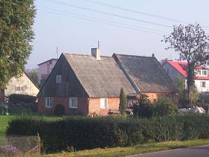
 A building at Młyńska street is a cowshed/barn
unit with a common ceramic roof situated on the eastern side of a yard
located on a small hill in the southern section of the village. Probably,
it is remnant of a Dutch homestead of the longitudinal type that had a
common roof. A new brick house was erected at the beginning of the 20th
century. A fragment of the old house was left and now forms an arcade in
front of the entrance to the cowshed. The roof is covered with pantiles.
The eastern section of the cowshed has a single storey, while the western
section has a low wooden second storey with a walled up arcade on the
southern side. The arcade rests on 5 thin posts reinforced with braces.
The barn has a single threshing floor, a large (double) mow, and
cubbyholes. A building at Młyńska street is a cowshed/barn
unit with a common ceramic roof situated on the eastern side of a yard
located on a small hill in the southern section of the village. Probably,
it is remnant of a Dutch homestead of the longitudinal type that had a
common roof. A new brick house was erected at the beginning of the 20th
century. A fragment of the old house was left and now forms an arcade in
front of the entrance to the cowshed. The roof is covered with pantiles.
The eastern section of the cowshed has a single storey, while the western
section has a low wooden second storey with a walled up arcade on the
southern side. The arcade rests on 5 thin posts reinforced with braces.
The barn has a single threshing floor, a large (double) mow, and
cubbyholes.
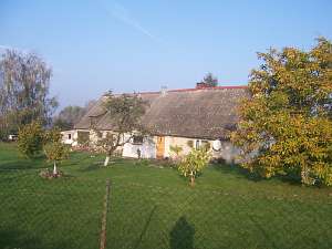
A building at Gronowska is a Dutch homestead (higher
farming section) of a longitudinal type located on the eastern side of the
road facing it with the ridge. The residential building (erected ca.
1840-50) is located in the northern section of the homestead. It has
a plastered corner-notched structure resting on a stone foundation, a
wooden queen post - purlin roof structure, a vertically boarded gable,
asbestos tile roofing, and a modified interior. The gable elevation has 1
axis and a two-level gable with 3 axes at the bottom, a window enclosed by
quarter circular small windows, and a semicircular small window above. The
frontal elevation has 5 axes and a 3-axial brick, centrally located
veranda. Farming buildings are covered with pantiles. The cowshed has 1.5
stories; its bottom section is made of brick, the upper section is wooden.
The barn (added at the beginning of the 20th century) has been demolished.
It had one threshing floor and one mow.
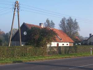
 A building at Nowa street
is a Dutch homestead of the longitudinal type situated on the northern
side of the local road. The farming section is higher and includes a
plastered cowshed and a bricked barn (asbestos tile roofing). It is
separated from the residential section with a fire wall. The house is
situated on the northern side. It dates from mid 1850s and has a plastered
corner-notched structure, a vertically boarded gable, and a pantile roof.
The gable elevation has 2 axes and a two-level gable with 4 axes at the
lower level two windows enclosed by small windows and a small window
above. The frontal elevation has 4 axes and an entrance with a small
wooden porch located in the 2nd axis from the south. The homestead also
includes a brick, 1.5 story granary/coach house located in the
southwestern section of the yard. A building at Nowa street
is a Dutch homestead of the longitudinal type situated on the northern
side of the local road. The farming section is higher and includes a
plastered cowshed and a bricked barn (asbestos tile roofing). It is
separated from the residential section with a fire wall. The house is
situated on the northern side. It dates from mid 1850s and has a plastered
corner-notched structure, a vertically boarded gable, and a pantile roof.
The gable elevation has 2 axes and a two-level gable with 4 axes at the
lower level two windows enclosed by small windows and a small window
above. The frontal elevation has 4 axes and an entrance with a small
wooden porch located in the 2nd axis from the south. The homestead also
includes a brick, 1.5 story granary/coach house located in the
southwestern section of the yard.
Piątkowski, s.61, .Mamuszka, 11-114; Lipińska, t. III, poz. 81; AGIV
|
)