|
gm. Malbork, pow. malborski, woj. pomorskie
Until 1945 Blumenstein (Gotha), Blumstein (Endersch, Schrötter)
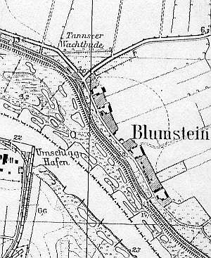
The village was founded at the end of the 14th century and initially was inhabited by minor gentry. In 1579, the village received a new charter; at the time the village acreage equaled 17 włókas. The village was included in the Dutch colinization. Name Claassen is mentioned as an owner of an arcaded house from 1800. Village layout - flood bank row village situated along the Nogat flood bank with 4 large farms on the eastern side of the road. The cultural landscape has survived partially. The village layout and homesteads are detectable. In 1986, 4 out of 5 historical homesteads still had old buildings. Preserved are a cobble stone road, considerable fragments of linden and chestnut tree rows, and buildings, dating mostly form the end of the 19th and the beginning of the 20th centuries (mostly transformed). New buildings preserve the traditional localization. Homestad vegetation has also survived. The old Lutheran cemetery has a Neogothic chapel from the beginning of the 20th century. The arcaded house has not survived. There is a new Catholic cemetery established after 1945 located in the central section of the village.
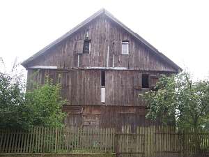 No. 21 is a granary/coach house situated in the southern
section of the village, facing the road with its gable. It dates from the
1st quarter of the 19th century. It is a 2-storey, half-timbered building
with vertical planking and a high, double pitched, ceramic roof. It is
located on the eastern side of the western street, facing it with its
ridge. Only the house and cowshed have survived until the present day.
Both buildings have a corner-notched structure; the cowshed was
converted into residential and utility rooms. The windows have been
partially replaced. No. 21 is a granary/coach house situated in the southern
section of the village, facing the road with its gable. It dates from the
1st quarter of the 19th century. It is a 2-storey, half-timbered building
with vertical planking and a high, double pitched, ceramic roof. It is
located on the eastern side of the western street, facing it with its
ridge. Only the house and cowshed have survived until the present day.
Both buildings have a corner-notched structure; the cowshed was
converted into residential and utility rooms. The windows have been
partially replaced.
 No. 11 is a building of an old inn. It
consists of two parts: the older part erected in the 1st half of the 19th
century and modified in the 3rd quarter of the 19th century (carpenters
replaced the roof and added a pointing sill) and the second section added
perpendicularly at the end of the 19th century (one-storey with a pointing
sill). No. 11 is a building of an old inn. It
consists of two parts: the older part erected in the 1st half of the 19th
century and modified in the 3rd quarter of the 19th century (carpenters
replaced the roof and added a pointing sill) and the second section added
perpendicularly at the end of the 19th century (one-storey with a pointing
sill).
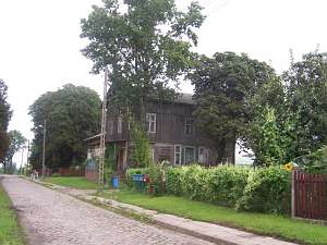
No. 17 is a detached house facing the road with its ridge.
It dates from the 1st. quarter of the 19th century. It has a
corner-notched log structure with quoins covered with boards and
half-timbered gables filled with bricks. The frontal elevation has 7 axes
with a centrally located entrance. The gable elevation has 4 axes. The
interior has been partially modified.
Schmid, s.33-34; Lipińska, t.III, poz.109.
|
)