|
gm. Gronowo Elbląskie, pow. elbląski, woj. warmińsko - mazurskie
Until 1945 Ober Kerbswalde(Gotha, Endersch Schrötter)
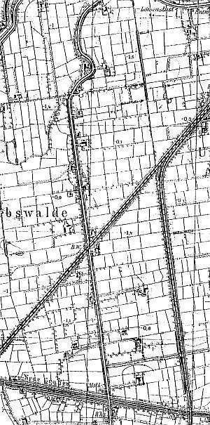
The village was established as a result of a division of depression area located by the lake Drużno (1580s) into eight 1-włóka plots. In 1586, a settlement was established on 6 of these plots. The sources from 1776 mentioned Arend, Gerbrand, Harms, Jantzen, Claassen, Puls, Penner, Peters, Quapp, Quiring, Riediger, Schepler, Schmid, Schrott, and van Riesen. In 1820, there were 301 residents, including 135 Mennonites. In 1868, the petition from Karczowiska was signed by Heinrich Essau, Heinrich Penner, and Peter Quapp. Village layout - row village on terpy The cultural landscape includes: a preserved layout of farms and terpy, historical buildings (in 1986, there were 14 historical buildings in 18 traditional homesteads) plastered or bricked with asbestos tile roofing, and a system of drainage canals and polders. Historical buildings have survived in fragments.
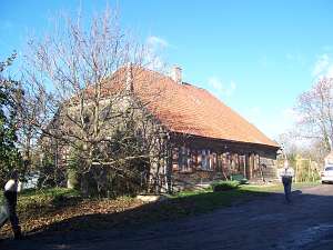
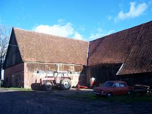
 No. 21 is a Dutch homestead of the longitudinal type with a
perpendicular cowshed situated on terpa removed from the main road. The
buildings date from the 2nd quarter of the 19th century and were modified
at the end of the 19th and the beginning of the 20th centuries, when the
original arcade was replaced by the current form. The homestead includes:
a house (eastern side), a cowshed, and a barn. The house is a one-storey
building with a pointing sill. It has a corner-notched log structure, a
boarded gable, and a wooden arcade (southern side) supported by 4 posts.
The decoration of the upper section of the ridge and wind ties in the form
of grid and fretwork has been partially preserved. The interior includes a
rectangular large room in the southeastern corner, a black kitchen in the
large room bay, and a Z-shaped, bipartite hallway, which separates the
residential and farming sections. No. 21 is a Dutch homestead of the longitudinal type with a
perpendicular cowshed situated on terpa removed from the main road. The
buildings date from the 2nd quarter of the 19th century and were modified
at the end of the 19th and the beginning of the 20th centuries, when the
original arcade was replaced by the current form. The homestead includes:
a house (eastern side), a cowshed, and a barn. The house is a one-storey
building with a pointing sill. It has a corner-notched log structure, a
boarded gable, and a wooden arcade (southern side) supported by 4 posts.
The decoration of the upper section of the ridge and wind ties in the form
of grid and fretwork has been partially preserved. The interior includes a
rectangular large room in the southeastern corner, a black kitchen in the
large room bay, and a Z-shaped, bipartite hallway, which separates the
residential and farming sections.
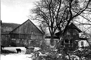
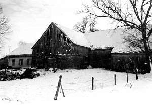
 A building without a number is
a Dutch homestead of the cross-shaped type situated in the northern
section of the village, on the western side of the road, separated from it
by a canal. It faces the road with the gable. The house is located on the
eastern side (cowshed is higher). It was erected at the end of the 18th
century; the arcade was taken down in 1970s. The building has a plastered
log structure, a boarded gable, a rafter roof structure, and pantile
roofing. The interior has 1.5 bays with the large room in the southeastern
corner, a black kitchen in the large room bay, and a bipartite hallway.
The gable elevation has 2 axes and a two-level gable with 2 axes in the
lower section and a single window above. The frontal elevation has 4 axes
and an entrance in the 2nd axis from the west. The 1.5-storey cowshed has
a brick lower section and a tenon-post boarded structure in the upper
section. There are two barns (one threshing floor, one mow, plus
cubbyholes) on both sides of the cowshed and a wooden granary in the
northeastern part of the yard. A house from the beginning of the 20th
century is located in the southern part. A building without a number is
a Dutch homestead of the cross-shaped type situated in the northern
section of the village, on the western side of the road, separated from it
by a canal. It faces the road with the gable. The house is located on the
eastern side (cowshed is higher). It was erected at the end of the 18th
century; the arcade was taken down in 1970s. The building has a plastered
log structure, a boarded gable, a rafter roof structure, and pantile
roofing. The interior has 1.5 bays with the large room in the southeastern
corner, a black kitchen in the large room bay, and a bipartite hallway.
The gable elevation has 2 axes and a two-level gable with 2 axes in the
lower section and a single window above. The frontal elevation has 4 axes
and an entrance in the 2nd axis from the west. The 1.5-storey cowshed has
a brick lower section and a tenon-post boarded structure in the upper
section. There are two barns (one threshing floor, one mow, plus
cubbyholes) on both sides of the cowshed and a wooden granary in the
northeastern part of the yard. A house from the beginning of the 20th
century is located in the southern part.
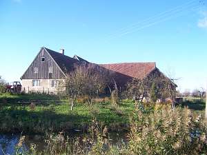
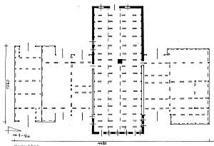 No. 16 is a farming
complex situated on the southern side of railway tracks, on the eastern
side of the road. It includes a detached house, a granary, and
interconnected (cross-shape layout) cowshed and two barns. No. 16 is a farming
complex situated on the southern side of railway tracks, on the eastern
side of the road. It includes a detached house, a granary, and
interconnected (cross-shape layout) cowshed and two barns.
The
house dates from the 1st quarter of the 19th century. It was modified at
the end of the 19th century. It has brick foundation, a log structure
connected by dovetail halvings with quoins covered by boards imitating
Tuscan pilaster (a board with a column profile with an entasis has been
preserved), a queen post - purlin, two-level roof structure, and a ceramic
partially-hipped roof. The interior has a two-bay layout with wider
western bay and the large room in the southwestern corner. A black kitchen
is slightly shifted towards the yard bay. It has a square, decorated
hallway behind the arcade, next to the western wall and a T-shaped utility
hallway that separates the farming spaces in the northeastern section of
the house. The gable elevation has 3 axes and a 4-axial gable with two
windows enclosed by two rhomboidal small windows. The frontal elevation is
symmetrical and has 7 axes with an entrance in the center of a recessed
arcade (with a porch). There is a 2-axial attic room. Window frames and
architectural decorations have been preserved. A long cowshed was modified
in 1880. It has 1.5 stories. The "second storey" has a boarded post
structure. On the northern side, there is an adjacent barn with one
threshing floor a deep mow and two cubbyholes. On the southern side, there
is another barn with a threshing floor, two mows, and cubbyholes. The
homestead also has a two-storey granary resting on a stone foundation. It
has a vertically boarded post - frame structure with a ceramic roof. The
northern elevation has 9 axes (ground floor) with alternating narrow
windows and a double-leaf door. The upper level has 3-axes. The gable
elevation has 2 axes and 3 levels.
No. 26 is a Dutch homestead of
the angular type situated on the eastern bank of the Fiszewka, in the
southern section of the colony, facing the road with the ridge. A cowshed
was separated from the rest with a high fire wall. There also was a
perpendicular barn (on the north). Both buildings have been taken down.
The house was erected in the 1st quarter of the 19th century and until
1945 belonged to Izbaner. Originally, it had a corner-notched log
structure with corners covered with boards imitating Tuscan pilaster, a
boarded gable, and a half-timbered porch on the western side. The interior
has 1.5 bays with the large room in the southwestern corner, a black
kitchen in the large room bay, a bipartite L-shaped hallway. The building
has been heavily modified. Only original shape of the gable has
survived.
Piątkowski, s.23, Lipińska t. III, poz. 82;AG IV; BF.
|
)