|
gm. Elbląg, pow. elbląski, woj. warmińsko - mazurskie
Until 1945 Ellerwald Dritte Trift TK (Endersch, Schrőtter), Pflinzentrift
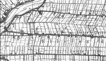
In the Teutonic Knight period, the area of the present-day villages of Adamowo, Kazimierzowo, Janowo, Władysławowo, and Helenowo was covered by marshes, which after digging the Kanał Jagielloński in 1495 were converted into meadows that belonged to Stare Miasto. The development of the meadows began in 1563 when 4 causeways were built; the areas adjacent to these causeways reflected the ownership structure of Stare Miasto in Elbląg. Four hundred thirty five plots were allocated, which corresponded to each tenement house in the town. In order to develop area, the burghers invited Dutch settlers. The Mennonites who lived in the area belonged to the Ellerwald-Elbing community. In 1776, the following Mennonite surnames were recorded in the Ellerwald villages: Barg, von Bergen, Block, Brand, Brandy, Dircksen, Dick, Sens, Essau, von Riesen, Guenther, Harm, Hiebert, Isaac, Jantzen, Kieler, Kroacker, Loewen, Martens, Neufeldt, Penner, Rempel, Sawatsky, Thiessen, Thimm, Toews, Weis, Wieb, Wiebe, Wieler, Wiens, and Wilmp. In 1921, the area was inhabited by 736 Mennonites. In 1820, in Kazimierzów, there were 276 residents, including 58 Mennonites. At the beginning of the 20th century, the village had 664 ha and 416 residents. Village layout - single homestead village on terpy and marsh row village with homesteads on both sides of the causeway. The cultural landscape has been relatively well preserved. The spatial layout is detectable with homestead layouts, network of draining canals, field layout, and trees lining the ditches. The village buildings mainly include Dutch homesteads of the longitudinal type with transformed or demolished farming buildings. The wooden houses are disappearing; however, brick houses have survived (transformed). Construction of warehouses and modern residential buildings has been very intensive in the eastern section of the village. In 1980s, out of 60 old homesteads, ca. 27 had historical buildings. 27. Currently, this number is lower.
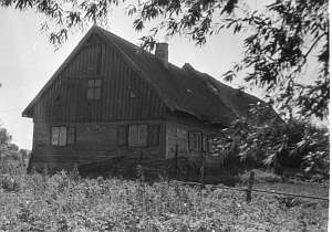
 No. 10 is a Dutch homestead of the longitudinal type located on the northern side of the road, facing it with the ridge. It was erected on a terpa in the 4th quarter of the 19th century. The building has a corner-notched structure with quoins covered with boards imitating Tuscan pilaster, vertically boarded pointing sill, gable, and attic room (southern roof slope), a queen post - purlin roof structure, and a ceramic roof. No. 10 is a Dutch homestead of the longitudinal type located on the northern side of the road, facing it with the ridge. It was erected on a terpa in the 4th quarter of the 19th century. The building has a corner-notched structure with quoins covered with boards imitating Tuscan pilaster, vertically boarded pointing sill, gable, and attic room (southern roof slope), a queen post - purlin roof structure, and a ceramic roof.
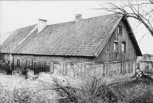
 No. 11 is a longitudinal Dutch homestead situated on the northern side of the road, facing it with its ridge. The house was erected at the end of the 19th century. It has a log structure with quoins covered with Tuscan column-shaped boards with entasis, a half-timbered pointing sill, vertically boarded gables, a stone foundation, and a wooden queen post - purlin roof structure. The interior has a two bay layout (southern bay wider), a centrally located black kitchen, and an L-shaped hallway separating the residential and farming sections. The gable elevation has 2 axes, a 3-axial gable, and a window enclosed by quarter circular small windows. The frontal elevation has 5 axes with an entrance in the 3rd axis from the west. No. 11 is a longitudinal Dutch homestead situated on the northern side of the road, facing it with its ridge. The house was erected at the end of the 19th century. It has a log structure with quoins covered with Tuscan column-shaped boards with entasis, a half-timbered pointing sill, vertically boarded gables, a stone foundation, and a wooden queen post - purlin roof structure. The interior has a two bay layout (southern bay wider), a centrally located black kitchen, and an L-shaped hallway separating the residential and farming sections. The gable elevation has 2 axes, a 3-axial gable, and a window enclosed by quarter circular small windows. The frontal elevation has 5 axes with an entrance in the 3rd axis from the west.

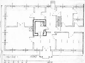
No. 39 is a longitudinal Dutch homestead located in the western side of the village, on a terpa, by the Nogat flood bank, facing the road with its ridge. The home was erected in 1870s. Until 1945, the building functioned as an inn owned by Paul Lucht. It has a corner-notched log structure with quoins covered by boards imitating Tuscan pilaster, a brick foundation, a wooden queen post - purlin roof structure with angle braces, a high roof with an attic room in its western slope, and vertically boarded gable and pointing sill. The interior has 2 bays with uneven bays, the large room in the southwestern corner, a centrally located black kitchen, and an L-shaped bipartite hallway, which separates the 2.5-bay eastern section from the western one (a cowshed passage separates the large southern room from several spaces in the northern section). The gable elevation has 3 axes, 4-axial gable, two wide windows enclosed by quarter circular skylights, and another window above. The frontal elevation has 6 axes with an entrance in the 3rd axis from the east. The entrance used to have a richly decorated porch. The cowshed and barn have been taken down.
Kerstan, s. 199 - 209; ML, t. I, s. 548 - 550; Piątkowski, Lipińska, t. III, poz. 60; AG , BF
|
)