|
gm. Nowy Staw, pow. malborski, woj. pomorskie
Until 1945 Neuteicher Hinterfeld -TK (Schrötter)
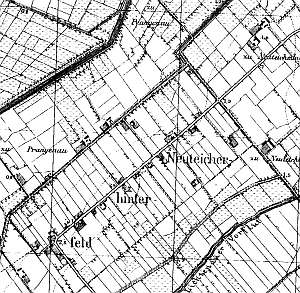
The village was established after 1772. In 1776, the following Mennonite surnames were mentioned: Claasen, Penner, Peters, Wieb, Willms, and Woelcke. In 1820, the village had 101 residents, including 16 Mennonites. Village layout - row village on terpy The cultural landscape has been well preserved. The spatial layout with ca. 9 homesteads of the Dutch type, including 6 wooden houses is detectable. The majority of old buildings have been modified or replaced. A linden tree alley has been partially preserved. The old field layout and a system of drainage canals are detectable.
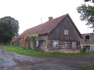 No. 23 is a longitudinal Dutch homestead consisting of a
home, a masonry cowshed, and a barn. It is situated in the southern
section of the village, on the eastern side of the road, facing it with a
ridge. The house dates from the mid 19th century. It has a log structure
with quoins joined by dovetail halvings, a brick underpinning, a
vertically boarded gable and pointing sill, a queen post - purlin roof
structure with an angle brace, and a tile roof. The southern elevation has
2 axes and a 1-axial gable. The southern elevation has 3 axes and an
entrance in the 2nd axis from the north. No. 23 is a longitudinal Dutch homestead consisting of a
home, a masonry cowshed, and a barn. It is situated in the southern
section of the village, on the eastern side of the road, facing it with a
ridge. The house dates from the mid 19th century. It has a log structure
with quoins joined by dovetail halvings, a brick underpinning, a
vertically boarded gable and pointing sill, a queen post - purlin roof
structure with an angle brace, and a tile roof. The southern elevation has
2 axes and a 1-axial gable. The southern elevation has 3 axes and an
entrance in the 2nd axis from the north.
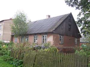 No. 17 is a house
from a Dutch homestead (a cowshed, which was separated from the rest with
a high fire wall, and a barn have not survived) situated in the village
center, on the eastern side of the road, facing it with its ridge. It
dates from 1880 and has a plastered log structure and pantile roofing. The
southern elevation has 2 axes, a two-level gable, a window enclosed by
triangular skylights, and a large window above. The western elevation has
5 axes and en entrance located in the 2nd axis from the north. No. 17 is a house
from a Dutch homestead (a cowshed, which was separated from the rest with
a high fire wall, and a barn have not survived) situated in the village
center, on the eastern side of the road, facing it with its ridge. It
dates from 1880 and has a plastered log structure and pantile roofing. The
southern elevation has 2 axes, a two-level gable, a window enclosed by
triangular skylights, and a large window above. The western elevation has
5 axes and en entrance located in the 2nd axis from the north.
 No. 2 is a longitudinal Dutch homestead consisting of a home, a
slightly higher, 1.5-storey cowshed (separated from the home by a fire
wall), and a wooden barn. It is situated in the colony, to the southeast
of the village, on the northern side of the road, facing it with its
ridge. The house dates from the 4th quarter of the 19th century and was
erected on a stone-brick underpinning. It has a plastered corner-notched
log structure, a vertically boarded gable, and asbestos tile roofing. The
eastern elevation has 3 axes, a 3-axial gable, and a window enclosed by
quarter circular skylights. The southern elevation has 5 axes, an entrance
located in the 2nd axis from the west, and a modern masonry
porch. No. 2 is a longitudinal Dutch homestead consisting of a home, a
slightly higher, 1.5-storey cowshed (separated from the home by a fire
wall), and a wooden barn. It is situated in the colony, to the southeast
of the village, on the northern side of the road, facing it with its
ridge. The house dates from the 4th quarter of the 19th century and was
erected on a stone-brick underpinning. It has a plastered corner-notched
log structure, a vertically boarded gable, and asbestos tile roofing. The
eastern elevation has 3 axes, a 3-axial gable, and a window enclosed by
quarter circular skylights. The southern elevation has 5 axes, an entrance
located in the 2nd axis from the west, and a modern masonry
porch.
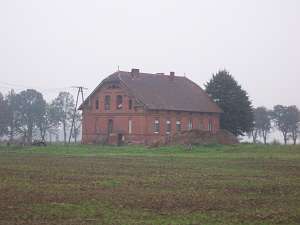 (Mennonite?) school erected at the turn of
the 19th and 20th centuries. It is a single-storey brick building resting
on a brick foundation. It has a low pointing sill and a partially hipped
roof covered with pantiles. The ridge elevation has 6 axes. The western
elevation has 3 axes in the gable and 4 axes in the ground floor. Above,
there is a low thermal window. The building is richly decorated - block
cornices, ornamented window and door frames, and octagonal star motifs.No.
23 is a longitudinal Dutch homestead consisting of a home, a masonry
cowshed, and a barn. It is situated in the southern section of the
village, on the eastern side of the road, facing it with a ridge. The
house dates from the mid 19th century. It has a log structure with quoins
joined by dovetail halvings, a brick underpinning, a vertically boarded
gable and pointing sill, a queen post - purlin roof structure with an
angle brace, and a tile roof. The southern elevation has 2 axes and
a 1-axial gable. The southern elevation has 3 axes and an entrance in the
2nd axis from the north. (Mennonite?) school erected at the turn of
the 19th and 20th centuries. It is a single-storey brick building resting
on a brick foundation. It has a low pointing sill and a partially hipped
roof covered with pantiles. The ridge elevation has 6 axes. The western
elevation has 3 axes in the gable and 4 axes in the ground floor. Above,
there is a low thermal window. The building is richly decorated - block
cornices, ornamented window and door frames, and octagonal star motifs.No.
23 is a longitudinal Dutch homestead consisting of a home, a masonry
cowshed, and a barn. It is situated in the southern section of the
village, on the eastern side of the road, facing it with a ridge. The
house dates from the mid 19th century. It has a log structure with quoins
joined by dovetail halvings, a brick underpinning, a vertically boarded
gable and pointing sill, a queen post - purlin roof structure with an
angle brace, and a tile roof. The southern elevation has 2 axes and
a 1-axial gable. The southern elevation has 3 axes and an entrance in the
2nd axis from the north.
No. 17 is a house from a Dutch
homestead (a cowshed, which was separated from the rest with a high fire
wall, and a barn have not survived) situated in the village center, on the
eastern side of the road, facing it with its ridge. It dates from 1880 and
has a plastered log structure and pantile roofing. The southern elevation
has 2 axes, a two-level gable, a window enclosed by triangular skylights,
and a large window above. The western elevation has 5 axes and en entrance
located in the 2nd axis from the north.
No. 2 is a longitudinal
Dutch homestead consisting of a home, a slightly higher, 1.5-storey
cowshed (separated from the home by a fire wall), and a wooden barn. It is
situated in the colony, to the southeast of the village, on the northern
side of the road, facing it with its ridge. The house dates from the 4th
quarter of the 19th century and was erected on a stone-brick underpinning.
It has a plastered corner-notched log structure, a vertically boarded
gable, and asbestos tile roofing. The eastern elevation has 3 axes, a
3-axial gable, and a window enclosed by quarter circular skylights. The
southern elevation has 5 axes, an entrance located in the 2nd axis from
the west, and a modern masonry porch.
No. ... is a (Mennonite?)
school erected at the turn of the 19th and 20th centuries. It is a
single-storey brick building resting on a brick foundation. It has a low
pointing sill and a partially hipped roof covered with pantiles. The ridge
elevation has 6 axes. The western elevation has 3 axes in the gable and 4
axes in the ground floor. Above, there is a low thermal window. The
building is richly decorated - block cornices, ornamented window and door
frames, and octagonal star motifs.
Kerstan, s. 199 - 209; ML, t. I, s. 548 - 550; Piątkowski, Lipińska, t. III, poz. 60; AG , BF
|
)