|
gm. Nowy Dwór Gdański, pow. nowodworski, woj. pomorskie
Until 1945 ZeyerTK (Gotha, Endersch, Schrötter)
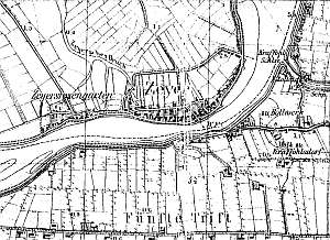
The village existed already in the Prussian period - Sura. Later, it was granted the Chełmno charter by the Teutonic Knights and became a part of the Elbląg land estate. The sources from 1295 mentioned a tenant Berthold. A ferry crossing functioned in the village since the Middle Ages until 2006, when the bridge was completed. The church, which was erected in the 14th century, was replaced by a half-timbered church in 1663. It was located on the eastern bank of the Nogat within the area of the current village of Bielnik. The village was not incorporated in the Dutch colonization; it was a primarily a fishing and a ferry crossing village. But the presence of Dutch settlers was also mentioned. In 1820, Kępki had 589 residents, including 8 Mennonites. The 1868 petition was signed by a merchant J. Dyck. Village layout - flood bank linear village located on the western bank of the Nogat with buildings along the road to Marzęcin. The cultural landscape is in good condition. Three homesteads of the longitudinal type and 7 of the angular type have survived with replaced farming buildings. There are 13 wooden houses, 5 masonry houses, one wooden and one masonry granaries, two inns, and a school. Almost all historical buildings date from the end of the 19th century or the beginning of the 20th century. Modern buildings are scarce. A field layout and a drainage canal network are detectable in the western section of the village.
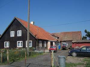 No. 32 is a Dutch homestead of the Winkelhoff type consisting
of a wooden house, a brick cowshed, and a perpendicular barn. It is
situated in the southern section of the village facing the flood bank with
its gable. The house has a log structure with boarded quoins, a queen post
- purlin roof structure, and a high ceramic roof. The gable elevation has
3 axes and a 2-axial gable. The side elevation has 5 axes. The building
has been transformed and the decorative elements removed. No. 32 is a Dutch homestead of the Winkelhoff type consisting
of a wooden house, a brick cowshed, and a perpendicular barn. It is
situated in the southern section of the village facing the flood bank with
its gable. The house has a log structure with boarded quoins, a queen post
- purlin roof structure, and a high ceramic roof. The gable elevation has
3 axes and a 2-axial gable. The side elevation has 5 axes. The building
has been transformed and the decorative elements removed.
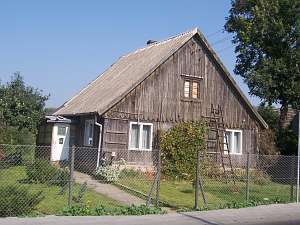 No.
23 is a house from a Dutch homestead situated in the western section
of the village, on the northern side of the road to Marzęcin, facing it
with its gable. The building has a vertically boarded log structure with
carved boards of the gable. The gable wall has 2 axes with a single window
in the gable. The side elevation has 4 axes. No.
23 is a house from a Dutch homestead situated in the western section
of the village, on the northern side of the road to Marzęcin, facing it
with its gable. The building has a vertically boarded log structure with
carved boards of the gable. The gable wall has 2 axes with a single window
in the gable. The side elevation has 4 axes.
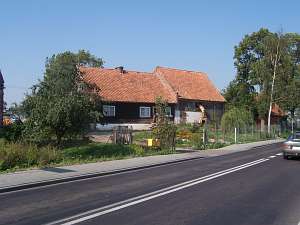 No. 15 is a Dutch
homestead. Originally, it probably had the longitudinal layout. The
homestead is situated in the western section of the village on the western
side of the road to Marzęcin, facing it with its ridge. It includes a
wooden house and a wooden/brick, 1.5-storey cowshed. There is also a
masonry granary/coach house in the northeastern section of the yard. No. 15 is a Dutch
homestead. Originally, it probably had the longitudinal layout. The
homestead is situated in the western section of the village on the western
side of the road to Marzęcin, facing it with its ridge. It includes a
wooden house and a wooden/brick, 1.5-storey cowshed. There is also a
masonry granary/coach house in the northeastern section of the yard.
Kerstan, 416-417; Piątkowski; Lipińska, t. III, poz. 155; Józefczyk, s. 255; AG.
|
)