|
gm. Markusy, pow. elbląski, woj. warmińsko - mazurskie
Until 1945 Campenau TK (Gotha, Endersch, Schrötter)
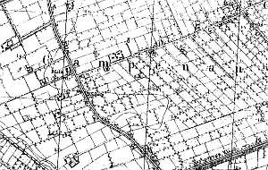
The village was founded by the Teutonic Knights in 1337. Initially the village was located directly by the western shore of lake Drużno. Later, in the 16th century, the shoreline receded and a marsh was formed and then wet-ground forest. In 1558, the forest located to the east of Kępniewo was cleared by the flood bank association and timber was used to reinforce the flood bank. Ca. 1590, the cleared area was settled by Dutch under the emphyteutic contract - primarily Mennonites, who began to develop the area. The sources from 1776 mentioned the follwing surnames Albrecht, Dau, Dick, Dircksen, Friesen, Froes, Funck, Goertzen, Jantzen, Kleewer, Martens, Nickel, Pauls, Penner, Pholipsen, Quirling, Siebert, and Tank. In 1820, the village had 410 residents, including 98 Mennonites. The petition from 1868 was signed by Dawid Cornelsen, Heinrich Harms, two Cornelius Jantzens, Franz, Heinrich, Peter and Rudolf Jantzen, Nickel, Cornelius, Johann and Franz Pauls, Ferdynand Peters, Peter Quapp, Schmidt, and Jacob Siebert, Village layout - marsh row village on the western side of the Zwierzno - Stare Dolno road, Waldhufendorf type village next to the causeway to Rachów, and a flood bank linear village on the northern side of the Modry Canal. The cultural landscape of the village (Dutch homesteads) is in decline. Typical Dutch homesteads are disappearing with houses being their most durable elements. The majority of them have been modified or replaced by modern buildings that have nothing in common with the traditional architecture. Layouts of old Dutch homesteads have survived in relatively large numbers - ca. 35.The majority of historical buildings date from the 2nd half of the 19th century. They include ca. 25 wooden and bricked houses. An 18th century house from a Dutch homestead (demolished in 1990s), a cowshed with a gable arcade, and a Mennonite cemetery have survived. The cemetery is severely devastated with fragments of surrounding vegetation, a gate, and remains gravestones. A field layout on the eastern and western sides of roads and a canal and ditch network are well detectable. Fragments of homestead vegetation homesteads have survived. Trees lining the roads have been cut down, but the rows of willows lining the drainage canals have survived.
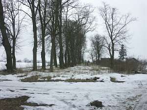 The Mennonite cemetery is located ca. 150 m to the west of
the Zwierzno - Stare Dolno road, on the northern side of a birch alley. It
was established at the end of the 18th century and has a rectangular
layout, two uneven plots with linden tree rows. There are 140 graves with
gravestones of the following families: Boerzen, Froehlich, Gringel,
Grunau, Heinrichs,Jarke, Jansen, Penner, Riesen, and Unger. The oldest
preserved gravestone in the form of a cippus dates from 1796. There are
also 2 cippuses, 7 stalls, 2 cast iron crosses, and a granite grave of the
Janzens. The Mennonite cemetery is located ca. 150 m to the west of
the Zwierzno - Stare Dolno road, on the northern side of a birch alley. It
was established at the end of the 18th century and has a rectangular
layout, two uneven plots with linden tree rows. There are 140 graves with
gravestones of the following families: Boerzen, Froehlich, Gringel,
Grunau, Heinrichs,Jarke, Jansen, Penner, Riesen, and Unger. The oldest
preserved gravestone in the form of a cippus dates from 1796. There are
also 2 cippuses, 7 stalls, 2 cast iron crosses, and a granite grave of the
Janzens.
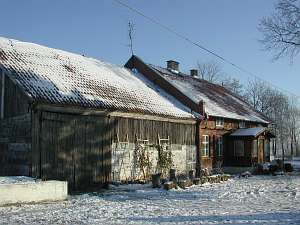 No. 22 is a Dutch homestead of the longitudinal type
situated on the eastern side of the Zwierzno - Brudzędy road, facing it
with its ridge. The home was erected at the beginning of the 20th century
in place of an earlier house. It is made of brick and has a stone/brick
underpinning, a gable and a pointing sill decorated with Fachwerk, and
pantile roofing. The interior has a 2-bay layout with even bays and
without a black kitchen. The gable elevation has 2 axes, a two-level
gable, two windows enclosed by skylights, and a triangular window in the
finial. The western elevation has 5 axes and a centrally located
entrance with a porch. No. 22 is a Dutch homestead of the longitudinal type
situated on the eastern side of the Zwierzno - Brudzędy road, facing it
with its ridge. The home was erected at the beginning of the 20th century
in place of an earlier house. It is made of brick and has a stone/brick
underpinning, a gable and a pointing sill decorated with Fachwerk, and
pantile roofing. The interior has a 2-bay layout with even bays and
without a black kitchen. The gable elevation has 2 axes, a two-level
gable, two windows enclosed by skylights, and a triangular window in the
finial. The western elevation has 5 axes and a centrally located
entrance with a porch.
 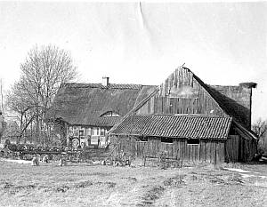 No. 32 is a Dutch homestead of the angular
type consisting of a house, a cowshed, and a perpendicular barn. The
homestead is located in the eastern section of the village, on the
southern side of the road (running perpendicularly) to Wiśniewo, facing it
with its ridge. The house was erected at the end of the 18th century on a
brick underpinning. It has a log structure with quoins covered by boards
with carved arches, a half-timbered vertically boarded gable, and a rafter
- collar beam roof structure. Originally, the roof (with a bullseye) was
thatched with reeds. The interior has a two-bay layout with a wider
southern bay and the large room in the southwestern corner, a black
kitchen in the large room bay, and an L-shaped hallway that separates the
northern farming section (with a corridor leading to the cowshed) from the
rest. Remains of old door frames and painted flowery friez have survived
inside the house. The gable elevation has 2 axes, a two-level gable, two
windows in the lower level enclosed by rhomboidal skylights, and a square
window in the finial. The southern elevation has 5 axes with an entrance
in the 2nd axis from the east. No. 32 is a Dutch homestead of the angular
type consisting of a house, a cowshed, and a perpendicular barn. The
homestead is located in the eastern section of the village, on the
southern side of the road (running perpendicularly) to Wiśniewo, facing it
with its ridge. The house was erected at the end of the 18th century on a
brick underpinning. It has a log structure with quoins covered by boards
with carved arches, a half-timbered vertically boarded gable, and a rafter
- collar beam roof structure. Originally, the roof (with a bullseye) was
thatched with reeds. The interior has a two-bay layout with a wider
southern bay and the large room in the southwestern corner, a black
kitchen in the large room bay, and an L-shaped hallway that separates the
northern farming section (with a corridor leading to the cowshed) from the
rest. Remains of old door frames and painted flowery friez have survived
inside the house. The gable elevation has 2 axes, a two-level gable, two
windows in the lower level enclosed by rhomboidal skylights, and a square
window in the finial. The southern elevation has 5 axes with an entrance
in the 2nd axis from the east.
No. 34 was a Dutch homestead of
the longitudinal type consisting of a house, a cowshed, and a barn. The
homestead is located in the eastern section of the village, on the
southern side of the road (running perpendicularly) to Wiśniewo, facing it
with its gable. The house was erected at the end of the 18th century on a
brick underpinning. It had a log structure with quoins covered by boards,
a half-timbered, vertically boarded gable, and a rafter - collar beam roof
structure covered by reed thatching. The interior had a two-bay layout
with a wider western bay and the large room in the northwestern corner, a
black kitchen in the large room bay, a wide hallway adjacent to the
cowshed wall. The gable elevation had 2 axes and a single window. The
southern elevation had 4 axes with an entrance in the southern axis. The
building does not exist.
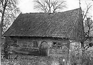
 No. 36 is an arcaded house from a Dutch
homestead situated in the eastern section of the village, on the northern
side of the crosswise road to Wiśniewo, facing it with its gable. The
house was erected in 1810 and modified in the 4th quarter of the 19th
century. It has a stone-brick underpinning, a log structure with quoins
covered by boards imitating Tuscan pilaster, a brick fire wall of a former
cowshed, a half-timbered vertically boarded gable, an extension (eastern
side) above an arcade supported by 12 wooden Ionian columns on brick
pedestals, a queen post - purlin, two-collar beam, two-level roof
structure, and pantile roofing. Currently, the interior consists of 3
similar bays, which were formed by dividing the large room and the arcade
hallway. After the cowshed had been demolished, the owner made an
additional entrance in the brick gable. A utility corridor became the
presentable section. The building is richly decorated - cones of Ionian
heads with volutes between them, scarf joints of rafters supporting a
profiled top plate, finials of the arcade and the house, carved wind ties
and planking. No. 36 is an arcaded house from a Dutch
homestead situated in the eastern section of the village, on the northern
side of the crosswise road to Wiśniewo, facing it with its gable. The
house was erected in 1810 and modified in the 4th quarter of the 19th
century. It has a stone-brick underpinning, a log structure with quoins
covered by boards imitating Tuscan pilaster, a brick fire wall of a former
cowshed, a half-timbered vertically boarded gable, an extension (eastern
side) above an arcade supported by 12 wooden Ionian columns on brick
pedestals, a queen post - purlin, two-collar beam, two-level roof
structure, and pantile roofing. Currently, the interior consists of 3
similar bays, which were formed by dividing the large room and the arcade
hallway. After the cowshed had been demolished, the owner made an
additional entrance in the brick gable. A utility corridor became the
presentable section. The building is richly decorated - cones of Ionian
heads with volutes between them, scarf joints of rafters supporting a
profiled top plate, finials of the arcade and the house, carved wind ties
and planking.
  No. 92 is a house from an old Dutch homestead of
the longitudinal type situated in the southern section of the village by
the Modry Canal, facing it with the ridge. Originally, the homestead had
an arcade added to the barn. Currently, only half of the house with an
extension for parents" has survived. The building was erected at the end
of the 18th century and modified in the 3rd quarter of the 19th century.
It has a corner-notched log structure with quoins covered by boards and a
rafter - collar beam roof structure. Only the eastern section with the
large room and an adjacent room has survived. The "parents section" has 3
rooms. There are remains of an arcade to the east of the house. It is used
as a separate utility room. No. 92 is a house from an old Dutch homestead of
the longitudinal type situated in the southern section of the village by
the Modry Canal, facing it with the ridge. Originally, the homestead had
an arcade added to the barn. Currently, only half of the house with an
extension for parents" has survived. The building was erected at the end
of the 18th century and modified in the 3rd quarter of the 19th century.
It has a corner-notched log structure with quoins covered by boards and a
rafter - collar beam roof structure. Only the eastern section with the
large room and an adjacent room has survived. The "parents section" has 3
rooms. There are remains of an arcade to the east of the house. It is used
as a separate utility room.
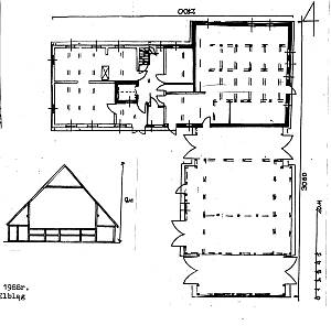
No. 92 was a granary (no longer
existing) situated on the western side of the yard, facing the Modry Canal
with its ridge. According to an inscription carved in a header, it was
erected in 1776 for an owner with initials H. R. by a carpenter A. R. The
building had a stone underpinning, log structure with quoins connected by
shallow scarf joints with side notches (covered by boards), vertically
boarded gables, and a rafter - collar beam roof structure. A small room
was sectioned off in the northeastern corner. The gable elevation had 2
axes and a side elevation, 4 axes with an entrance in the 2nd axis from
the west.
AG IV; BF;MP, Lipińska, t. III, poz. 123.
|
)