|
gm. Markusy, pow. elbląski, woj. warmińsko - mazurskie
Until 1945 Hohenwalde TK (Gotha, Endersch, Schrötter)
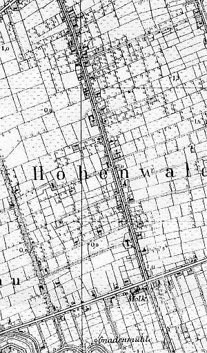
Until the 14th century, the area of Krzewsk was under water. In 1631, Dutch settlers began to develop the terrain. The sources form 1776 mentioned the following Mennonites: Bannmann, Bartz, Dau, Dircksen, Frantz, Friesen, Goertz, Goertzen, Harms, Horn, Huell, Jantz, Jantzen, Kopp, Martens, Nickel, Olwitz, Ott, Pauls, Penner, Peters, Plenert, Quiring, Roenert, Ross, Schmidt, Stob, Unger, and Wedle. In 1820, the village had 659 residents, including 175 Mennonites. In the 2nd half of the 19th century, the village had 70 włókas, 118 houses, 651 Lutherans and Catholics, and 167 Mennonites. Village layout - Waldhufendorf village on both sides of the Elbląg - Markusy road running on a causeway in a north-south line, on the western side of the parallel road, on the eastern side of a polder; its eastern farms belong to the village of Żółwieniec, on the southern side of a side street that divides farmland of Żurawiec and on both sides of a side road leading to Żółwieniec and to Markupy. The cultural landscape of the village, which included Dutch homesteads of the longitudinal on terpy is undergoing a gradual degradation, particularly along the eastern road. Residential buildings last the longest; the majority of them are made of brick. Currently, they are being modified or replaced by modern buildings. This is not a new phenomenon; some of the wooden houses were replaced at the beginning of the 20th century. Modern buildings have nothing in common with the traditional architectural style; buildings are often erected beyond a terpa. The layouts of the old Dutch homesteads have survived in relatively large numbers - ca. 35. 35. The majority of historical buildings date from the 2nd half of the 19th century. They include ca. 25 wooden and bricked houses. An 18th century house from a Dutch homestead (demolished in 1990s), a cowshed with a gable arcade, and a Mennonite cemetery have survived. The cemetery is severely devastated with fragments of surrounding vegetation, a gate, and gravestones. The field layout on eastern and western sides of roads and a canal and ditch network are well detectable. Fragments of vegetation surrounding homesteads have survived. Trees lining the roads have been cut down, but the rows of willows along the drainage canals have survived.
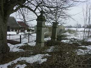 The Mennonite cemetery is located in the village center, on
the eastern side of the road. It has a rectangular layout. Two posts
of the gate in the form of pillars decorated with hexagonal stars and
topped with tetrahedronal copulas and fragments of gravestones have
survived. The cemetery is surrounded by linden trees and
thujas. The Mennonite cemetery is located in the village center, on
the eastern side of the road. It has a rectangular layout. Two posts
of the gate in the form of pillars decorated with hexagonal stars and
topped with tetrahedronal copulas and fragments of gravestones have
survived. The cemetery is surrounded by linden trees and
thujas.
No. - is a longitudinal Dutch homestead situated on the
eastern side of the road, facing it with its ridge. It includes a wooden
house from the 2nd half of the 19th century, a masonry cowshed and a barn.
The house has a plastered log structure and a vertically boarded
gable.
 
No. - is a Dutch homestead of the longitudinal type
situated on the western side of the road, facing it with its gable. It
includes a house, a cowshed and a barn. The home has a log structure with
quoins covered by decoratively carved boards and a vertically boarded
gable with slats. The gable elevation has 2 axes, 3-axial gable, and a
rectangular window enclosed by quarter circular skylights.>br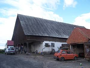 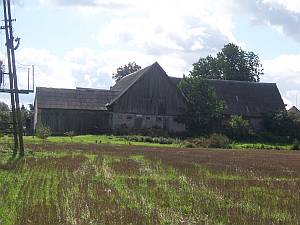
No. 24
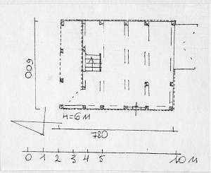
is a Dutch homestead consisting of a detached house, an interconnected
perpendicular barn, a utility building, and a cowshed with an arcade. The
house has a bricked wooden structure and a half-timbered, vertically
boarded gable. The gable elevation has 2 axes, a 3-axial gable with a
rectangular window enclosed by triangular skylights and a semicircular
window above. The cowshed is situated on the northern side of the yard.
The wooden barn is connected to the cowshed on the western side, and the
masonry utility building - on the eastern side. The cowshed has 1.5
stories with a brick ground floor, a half-timbered pointing sill, a
vertically boarded gable, and a protruding arcade supported by 6 wooden
posts reinforced with angle braces.
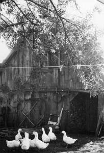  No. 53 is a granary situated
in the eastern side of the homestead. It has a vertically boarded,
half-timbered structure, a double-pitched ceramic roof, a gable arcade
supported by 4 posts reinforced by angle braces (on the north), an
entrance by the eastern wall, a gate on the northern side, and a staircase
by the arcade wall. The interior has a single space. No. 53 is a granary situated
in the eastern side of the homestead. It has a vertically boarded,
half-timbered structure, a double-pitched ceramic roof, a gable arcade
supported by 4 posts reinforced by angle braces (on the north), an
entrance by the eastern wall, a gate on the northern side, and a staircase
by the arcade wall. The interior has a single space.
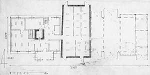
 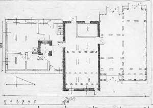 No. 73 is a
Dutch homestead of the longitudinal type situated in the central section
of the village, on the eastern side of the road, facing it with its ridge.
The farming section is higher. The homestead dates from the beginning of
the 19th century. The home has a plastered wooden structure with quoins
covered by carved boards, a rafter - collar beam roof structure, reed
thatching, and a bullseye in the southern roof slope. The interior has
1.5-bay layout with the large room in the southeastern corner, a black
kitchen in the large room bay, an L-shaped hallway by the cowshed wall
with stairs to the attic in the northwestern corner. The western elevation
has 4 axes with an entrance in the northern axis. The gable elevation has
2 axes. The building has been modified. No. 73 is a
Dutch homestead of the longitudinal type situated in the central section
of the village, on the eastern side of the road, facing it with its ridge.
The farming section is higher. The homestead dates from the beginning of
the 19th century. The home has a plastered wooden structure with quoins
covered by carved boards, a rafter - collar beam roof structure, reed
thatching, and a bullseye in the southern roof slope. The interior has
1.5-bay layout with the large room in the southeastern corner, a black
kitchen in the large room bay, an L-shaped hallway by the cowshed wall
with stairs to the attic in the northwestern corner. The western elevation
has 4 axes with an entrance in the northern axis. The gable elevation has
2 axes. The building has been modified.
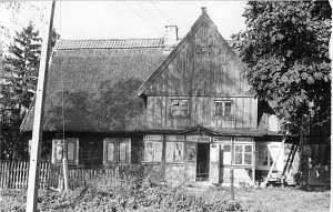  No. 29 is a house from a
longitudinal Dutch homestead situated in the central section of the
village, on the northern side of the road, facing it with its gable
(farming buildings demolished). It dates from the end of the 18th century.
Originally, it was an arcaded house, but at the beginning of the 20th
century an arcade was reduced to an attic room. The building has a
stone/brick underpinning, a log structure with quoins covered by profiled
boards, a half-timbered, vertically boarded attic room, a vertically
boarded gable, a rafter - double collar beam roof structure, and asbestos
tile roofing (originally reed thatching). The interior has 2 bays with a
wide northern bay, the large room in the southwestern corner, a black
kitchen in the large room bay, and a Z-shaped hallway separating the
summer room and a windowless room by the cowshed wall. The western
elevation has 3 axes, while the southern - 5 axes with an entrance
in the 2nd axis from the east. No. 29 is a house from a
longitudinal Dutch homestead situated in the central section of the
village, on the northern side of the road, facing it with its gable
(farming buildings demolished). It dates from the end of the 18th century.
Originally, it was an arcaded house, but at the beginning of the 20th
century an arcade was reduced to an attic room. The building has a
stone/brick underpinning, a log structure with quoins covered by profiled
boards, a half-timbered, vertically boarded attic room, a vertically
boarded gable, a rafter - double collar beam roof structure, and asbestos
tile roofing (originally reed thatching). The interior has 2 bays with a
wide northern bay, the large room in the southwestern corner, a black
kitchen in the large room bay, and a Z-shaped hallway separating the
summer room and a windowless room by the cowshed wall. The western
elevation has 3 axes, while the southern - 5 axes with an entrance
in the 2nd axis from the east.
SGKP, t.3,s.94; Lipińska, t. III, poz. 126; AG;BF
|
)