|
gm. Malbork, pow. malborski, woj. pomorskie
Until 1945 Gross Lesewitz TK (Gotha, Endersch, Schrőtter) (Lesewicz)
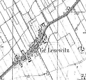
The village was mentioned in 1321. In 1350, the village charter was renewed by the Grand Master Heinrich Tusmer under the Chełmno law. The village had 95 włókas and 22 morgas of land. In the Teutonic Knights period, the village had a manor, which included the villages of Blumstein, Tenne, and Tragheim. The church, which was established during the first village foundation, was a Fachwerk building. It burned down during the first Swedish war. It was rebuilt between 1647 and 1654 and burned down again in 1811. It was rebuilt in 1824 and extended in 1896. The Lutheran church was erected in 1652, and in 1711, the residents erected a new Fachwerk church, which was replaced in 1903 with a brick church with a large tower. The sources from 1776 mentioned Mennonite Cornelius Epp. The sources from the beginning of the 19th century mentioned 11 Mennonites. In the 2nd half of the 19th century the village had 157 włókas of farmland, 15 homesteads, 18 minor gentry houses, 249 Catholics, 216 Lutherans, 29 Mennonites, and 47 houses. Among the richest owners were typical Mennonite surnames: J. Janzen, J.Wiebe, and G. Wiebe. Village layout - oval linear and square village in a north-south line with a church surrounded by a cemetery on the northern side of the square, an old Lutheran cemetery in the southern section of the village, a colony by the road to Tragamin, and an estate on the eastern side of the road to Lipinki. The cultural landscape is well preserved with a detectable spatial layout, a Catholic cemetery with a church and a cleaned up Lutheran cemetery with a preserved iron wrought fence, gates, and several gravestones. The Lutheran church and 18th century arcaded houses of Rudolf Wiebe, Dircksen, and Ernest Zimmermann have not survived. The road layout, remains of a narrow-gauge railroad along the eastern street, and traditional homesteads have survived. Many buildings have been modified or replaced preserving the traditional location. Several residential and farming buildings have survived.
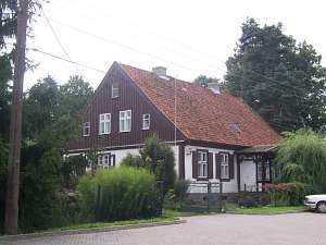
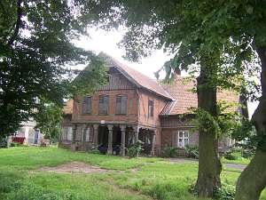 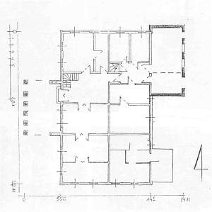 No. 12 is an arcaded house erected in 1837 for Zimmermann and
rebuilt in 1881. It is situated in the southern colony, on the eastern
side of the road, facing it with its ridge. The building has a
corner-notched log structure with quoins covered by boards imitating
pilaster, a half-timbered, vertically boarded pointing sill, vertically
boarded gables, a half-timbered extension (brick filling) supported by 6
Tuscan columns and half-timbered walls, a queen post - purlin roof
structure with an angle brace, and pantile roofing. The building has a
2-bay interior with similar bays - the large room in the southwestern
corner. The interior has been modified and has no black kitchen. There are
two separate hallways (one in each bay) interconnected by a short
corridor. The southern elevation has 4 axes, a two-level gable with 4 axes
in the lower level, two windows enclosed by quarter circular skylights,
and a semicircular window above. The western elevation has 7 axes with a
3-axial extension and an arcade in the 3 central axes and an entrance
located in the 3rd axis from the north. No. 12 is an arcaded house erected in 1837 for Zimmermann and
rebuilt in 1881. It is situated in the southern colony, on the eastern
side of the road, facing it with its ridge. The building has a
corner-notched log structure with quoins covered by boards imitating
pilaster, a half-timbered, vertically boarded pointing sill, vertically
boarded gables, a half-timbered extension (brick filling) supported by 6
Tuscan columns and half-timbered walls, a queen post - purlin roof
structure with an angle brace, and pantile roofing. The building has a
2-bay interior with similar bays - the large room in the southwestern
corner. The interior has been modified and has no black kitchen. There are
two separate hallways (one in each bay) interconnected by a short
corridor. The southern elevation has 4 axes, a two-level gable with 4 axes
in the lower level, two windows enclosed by quarter circular skylights,
and a semicircular window above. The western elevation has 7 axes with a
3-axial extension and an arcade in the 3 central axes and an entrance
located in the 3rd axis from the north.
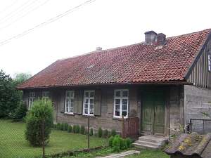 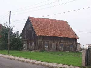 No. 15 is a homestead
situated in the southwestern section of the village consisting of a brick
house and farming buildings (a wooden granary and a barn) arranged around
a rectangular yard. The house was erected at the end of the 19th century.
It is a single-storey, brick building with a pointing sill and rich
architectural decoration - terracotta plates, sheet metal decorative
elements, and ceramic sculptures located in the gable niches. No. 15 is a homestead
situated in the southwestern section of the village consisting of a brick
house and farming buildings (a wooden granary and a barn) arranged around
a rectangular yard. The house was erected at the end of the 19th century.
It is a single-storey, brick building with a pointing sill and rich
architectural decoration - terracotta plates, sheet metal decorative
elements, and ceramic sculptures located in the gable niches.
The
granary dates from the beginning of the 19th century. It is a wooden,
two-storey building with a vertically boarded half-timbered structure
covered by double-pitched ceramic roof and a coach house with a gate
in the gable side.
No. 19 is a building situated in the western
side of the village, facing the street with its ridge. It dates from the
1st quarter of the 19th century. It is possible that 2 additional axes
have been added in the southern direction. It has a corner-notched and
tenon-post structure, vertically boarded gables, and a double-pitched roof
covered with pantiles. The ridge elevation has 6 axes with an entrance in
the outermost axis. The interior has been modified.
 No. 42 is a
detached house from the 1st half of the 19th century situated in the
eastern section of the village. It has a corner-notched structure,
vertically boarded gables, a symmetrical, 5-axial elevation with a
decorative gable in front of the centrally located entrance. No. 42 is a
detached house from the 1st half of the 19th century situated in the
eastern section of the village. It has a corner-notched structure,
vertically boarded gables, a symmetrical, 5-axial elevation with a
decorative gable in front of the centrally located entrance.
Schmid, s. 117 - 125; AG IV, BF, Lipińska, t. III, poz. 114
|
)