|
gm. Sztutowo, pow. nowodworski, woj. pomorskie
Until 1945 Lichtkampe, Kleiner und Groser Weidenhaken (Schrötter); Laschke,
In Middle Ages, the region located to the south of Sztutowo was a part of the Vistula Lagoon. Since the 16th century, the area was systematically drained and incorporated into the Sztutowo estate - Stuthofer kampe. Present day village of Łaszka includes several sections, which until 1945, were separate settlements: Lichtkampe by the Wisła Królewiecka, Kleiner Weidenhaken stretching along the northern bank of the Łaszka river, Łaszka Mleczarnia by the Grosser Weidenhaken river crossing, and the settlement of Łaszka. The village layout - the current village includes 6 settlements: former Lichtkampe (colonial homesteads located by the flood bank road on the southern side of the Wisła Królewska), Kleiner Weidekampe - a flood bank linear settlement stretching alnong the northern bank of the Brene Fart, Grosser Weidekampe (after 1945 Łaszka Mleczarnia) - a flood bank linear settlement located on the northern bank of the Łaszka river, a linear settlement with buildings on both sides of the road, and Norderhaken (until 1945; Wydmin - after 1945), and Sűdenhaken located on the western side of the road that separates Łaszka from Płonin. The cultural landscape is in good condition with clear layout of 18 Dutch homesteads (including angular homesteads) and 17 wooden houses from the 19th and the 20th centuries. Some buildings have been replaced preserving the layout of the former Dutch homestead (5 examples). In some homesteads, only a house has survived. Certain buildings have been modified. Traditional vegetation has survived in fragments. Field layout and a system of drainage canals are detectable.
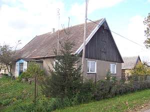
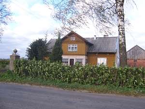
 A building without a number is a house from a Dutch homestead
situated in the northern section of the village (Wydmin), on the western
side of the road, facing it with its ridge (farming buildings demolished).
It was erected (transformed) in the 3rd quarter of the 19th century on a
brick underpinning. It has a log structure covered with roofing paper, a
vertically boarded gable, a rafter - collar beam roof structure, and a
ceramic roof. The eastern elevation has been transformed. It has 3 axes
and a profiled cornice. The southern elevation has 3 axes, a two-level
gable with 4 axes in the lower level, two windows enclosed by small
windows bound by segmented arches, and a semicircular window above. A building without a number is a house from a Dutch homestead
situated in the northern section of the village (Wydmin), on the western
side of the road, facing it with its ridge (farming buildings demolished).
It was erected (transformed) in the 3rd quarter of the 19th century on a
brick underpinning. It has a log structure covered with roofing paper, a
vertically boarded gable, a rafter - collar beam roof structure, and a
ceramic roof. The eastern elevation has been transformed. It has 3 axes
and a profiled cornice. The southern elevation has 3 axes, a two-level
gable with 4 axes in the lower level, two windows enclosed by small
windows bound by segmented arches, and a semicircular window above.
 No. 26 is a house (from the beginning of the 20th century) from
a Dutch homestead (farming buildings demolished) situated in the
Querhacken (until 1945) section of the village, on the northern bank of
the local branch of the Łaszka, on the western side of the road, facing it
with its gable. It is made of wood (plastered) and has a vertically
boarded gable, a rafter - collar beam roof structure, and interlocking
tile roofing. The eastern elevation has 2 axes and a single-axial gable
with a fretwork decoration in the top. The southern elevation has 3
axes and a centrally located entrance with a porch. No. 26 is a house (from the beginning of the 20th century) from
a Dutch homestead (farming buildings demolished) situated in the
Querhacken (until 1945) section of the village, on the northern bank of
the local branch of the Łaszka, on the western side of the road, facing it
with its gable. It is made of wood (plastered) and has a vertically
boarded gable, a rafter - collar beam roof structure, and interlocking
tile roofing. The eastern elevation has 2 axes and a single-axial gable
with a fretwork decoration in the top. The southern elevation has 3
axes and a centrally located entrance with a porch.
 No. 33 is a
house from a Dutch homestead (outbuildings are new) situated in the
northeastern section of the village (until 1945, Goddatsch), on the
southern side of the road, facing it with its ridge. It was erected
(rebuilt) in 1921 in place of an earlier building and until 1945 belonged
to the Freitag family. Its wooden, vertically boarded structure rests on a
brick underpinning. The building has 1.5 stories, a vertically boarded
gable, an extension with a herringbone boarded gable, a queen post -
purling roof structure, and sheet metal roofing. The interior and
elevations have been modified. The entrance has a glazed-in modern
porch. No. 33 is a
house from a Dutch homestead (outbuildings are new) situated in the
northeastern section of the village (until 1945, Goddatsch), on the
southern side of the road, facing it with its ridge. It was erected
(rebuilt) in 1921 in place of an earlier building and until 1945 belonged
to the Freitag family. Its wooden, vertically boarded structure rests on a
brick underpinning. The building has 1.5 stories, a vertically boarded
gable, an extension with a herringbone boarded gable, a queen post -
purling roof structure, and sheet metal roofing. The interior and
elevations have been modified. The entrance has a glazed-in modern
porch.
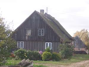 No. 35 is a Dutch homestead of the angular type (the lower
section of a brick cowshed from the 4th quarter of the 19th century has
been modified, a barn - demolished) situated in the flood bank section of
the village (Grosser Weidenhaken), on the southern side of the local road.
The cowshed is slightly higher. The house was erected in the 3rd quarter
of the 19th century on a brick underpinning. It has a corner-notched
log structure covered with roofing paper, a vertically boarded gable, a
rafter - collar beam roof structure, and a thatched roof. The eastern
elevation has 2 axes and a 2-axial gable. The northern elevation
has 4 axes. No. 35 is a Dutch homestead of the angular type (the lower
section of a brick cowshed from the 4th quarter of the 19th century has
been modified, a barn - demolished) situated in the flood bank section of
the village (Grosser Weidenhaken), on the southern side of the local road.
The cowshed is slightly higher. The house was erected in the 3rd quarter
of the 19th century on a brick underpinning. It has a corner-notched
log structure covered with roofing paper, a vertically boarded gable, a
rafter - collar beam roof structure, and a thatched roof. The eastern
elevation has 2 axes and a 2-axial gable. The northern elevation
has 4 axes.
No. 36 is a Dutch homestead of the angular type
(a brick cowshed 1920s is slightly higher, a barn - demolished) situated
in the flood bank section of the village (Grosser Weidenhaken), on the
southern side of the local road. The house was erected in the 3rd quarter
of the 19th century on a brick underpinning. It has a plastered log
structure, a vertically boarded gable, a rafter - collar beam roof
structure, and a thatched roof. The eastern elevation has 2 axes
and a 2-axial gable. The northern elevation has 3 axes -
transformed.
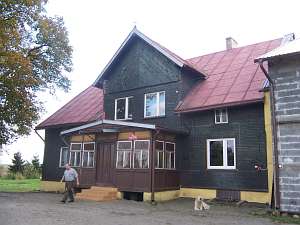
 No. 22 is a Dutch homestead of the angular type with
a new cowshed separated by a fire wall (barn - demolished). The homestead
is located in the western section of the village, on the northern side of
the local road. The house was erected in the 4th quarter of the 19th
century or at the beginning of the 20th century. It has a brick
underpinning, a horizontally boarded log structure, a vertically boarded
pointing sill and gable, a queen post - purlin roof structure with angle
braces, a 2-axial attic room in the southern roof slope, a porch, and
asbestos tile roofing. The western elevation has 2 axes, a 4-axial gable,
two windows enclosed by small skylights, and a square window above. The
southern elevation has 3 axes at the ground level and a centrally located
entrance with a porch. The windows of the pointing sill are in line with
the axes. The attic room has 2 axes. The western gable and the attic room
are richly decorated with fretwork. No. 22 is a Dutch homestead of the angular type with
a new cowshed separated by a fire wall (barn - demolished). The homestead
is located in the western section of the village, on the northern side of
the local road. The house was erected in the 4th quarter of the 19th
century or at the beginning of the 20th century. It has a brick
underpinning, a horizontally boarded log structure, a vertically boarded
pointing sill and gable, a queen post - purlin roof structure with angle
braces, a 2-axial attic room in the southern roof slope, a porch, and
asbestos tile roofing. The western elevation has 2 axes, a 4-axial gable,
two windows enclosed by small skylights, and a square window above. The
southern elevation has 3 axes at the ground level and a centrally located
entrance with a porch. The windows of the pointing sill are in line with
the axes. The attic room has 2 axes. The western gable and the attic room
are richly decorated with fretwork.
 No. 11 is a Dutch homestead
with new farming buildings, which extend beyond the former layout (only a
fire wall remained from the old cowshed), located in the western section
of the village, on the northern side of the local road. The house was
erected in the 4th quarter of the 19th century or at the beginning
of the 20th century. It has a brick underpinning, a vertically
boarded log structure, a ceramic roof resting on a pointing sill, a queen
post - purlin roof structure with angle braces, and a porch in front of
the entrance. The western elevation currently has 1 axis, and a 4-axial
gable; there are two windows enclosed by small skylights and a
semicircular skylight above. The southern elevation has 4 axes at the
ground level and an entrance with a porch in the 2nd axis from the
east. No. 11 is a Dutch homestead
with new farming buildings, which extend beyond the former layout (only a
fire wall remained from the old cowshed), located in the western section
of the village, on the northern side of the local road. The house was
erected in the 4th quarter of the 19th century or at the beginning
of the 20th century. It has a brick underpinning, a vertically
boarded log structure, a ceramic roof resting on a pointing sill, a queen
post - purlin roof structure with angle braces, and a porch in front of
the entrance. The western elevation currently has 1 axis, and a 4-axial
gable; there are two windows enclosed by small skylights and a
semicircular skylight above. The southern elevation has 4 axes at the
ground level and an entrance with a porch in the 2nd axis from the
east.
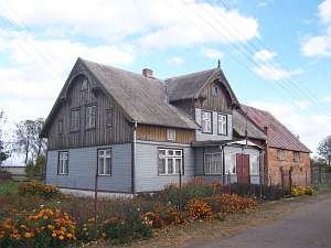
 No. 1 is a house from an angular Dutch homestead (farming
buildings - demolished) situated in the western section of the village, on
the northern side of the road, facing it with its ridge. The building was
erected (rebuilt) at the end of the 19th century on a brick underpinning.
It has a log structure with quoins covered by boards imitating
rustication, vertically boarded pointing sill and attic room, a rafter -
collar beam roof structure, and asbestos tile roofing. The structure is
boarded partially by herring bone boards and partially by vertical boards.
The arcade has been walled-up and plastered. The western elevation has 3
axes, a two-level gable (4 axes at the lower level), two windows enclosed
by small windows, and a small window bound by double segmented arches
above. The southern elevation has been modified. It has 5 axes with a
3-axial, single-storey projection formed by the walled-up arcade with an
extension and a small window bound by segmented arches in the gable. There
is a brick granary from 1937 in the southwestern section of the homestead
and a gate with antic vases set on pedestals. No. 1 is a house from an angular Dutch homestead (farming
buildings - demolished) situated in the western section of the village, on
the northern side of the road, facing it with its ridge. The building was
erected (rebuilt) at the end of the 19th century on a brick underpinning.
It has a log structure with quoins covered by boards imitating
rustication, vertically boarded pointing sill and attic room, a rafter -
collar beam roof structure, and asbestos tile roofing. The structure is
boarded partially by herring bone boards and partially by vertical boards.
The arcade has been walled-up and plastered. The western elevation has 3
axes, a two-level gable (4 axes at the lower level), two windows enclosed
by small windows, and a small window bound by double segmented arches
above. The southern elevation has been modified. It has 5 axes with a
3-axial, single-storey projection formed by the walled-up arcade with an
extension and a small window bound by segmented arches in the gable. There
is a brick granary from 1937 in the southwestern section of the homestead
and a gate with antic vases set on pedestals.
Lipińska, t. III, poz. 164
|
)