|
gm. Miłoradz, pow. malborski, woj. pomorskie
Until 1945 Mielenz TK (Schrötter), Mühlenz (Endersch), Mihlenz (Gotha),
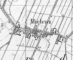
The village existed before the Teutonic Knights period and was mentioned in 1282 as Miloradesdorf. In 1321, the village was granted the Chełmno charter by the Grand Commander von Orseln. In 1820, the village had 298 residents, including 21 Mennonites and in the 1860s - 136 włókas and 4 morgas of land, 43 houses, and 495 residents, including 26 Mennonites. Village layout - an oval village in an east-west line with a well developed network of local roads. Westward roads led to Mątowy Wielkie and Mątowy Małe and to colonies located northwest of Miłoradz; eastern roads led to Kraśniew and Pogorzała Wieś. The village had a perpendicular road to Kłosów and Stara Kościelnica. The village has a centrally located church surrounded by a cemetery. At the eastern and western ends of the village, the buildings were located on the southern and northern sides of encircling streets, while the southern section of the village included two large farms. A considerable part of the cultural landscape has been preserved with a Gothic Archangel Michael parish church (a wooden belfry) and traditional location of buildings. Among the most interesting examples of historical architecture are two wooden houses (no. 3 and 26), an arcaded house (no. 23), 10 brick houses with farming buildings from the beginning of the 20th century , and remains of an old manor with a Classical manor house from the mid 1800s and a bricked-in (old form has been preserved) long barn. The cemetery still has fragments of encircling vegetation and several old gravestones. A historical field layout is still detectable in the northern and southern sections of the village.
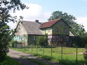 No. 23 (25/27) is an arcaded house dating from the 2nd
quarter of the 19th century situated in the western section of the
village, on the southern side of an encircling road, facing it with its
ridge. It has a log structure with boarded quoins, vertically boarded,
half-timbered gables, and an arcade located in the center of the northern
elevation and supported by 6 posts. It was converted in to a glazed-in
veranda with a half-timbered (plastered brick filling) extension above.
The building has been partially modified. No. 23 (25/27) is an arcaded house dating from the 2nd
quarter of the 19th century situated in the western section of the
village, on the southern side of an encircling road, facing it with its
ridge. It has a log structure with boarded quoins, vertically boarded,
half-timbered gables, and an arcade located in the center of the northern
elevation and supported by 6 posts. It was converted in to a glazed-in
veranda with a half-timbered (plastered brick filling) extension above.
The building has been partially modified.
No. 28 is a wooden
building dating from the end of the 19th century. It has a log structure
with covered quoins, boarded gables, a high, double pitched, ceramic roof,
and the main entrance in the center of a 5-axial frontal
elevation.
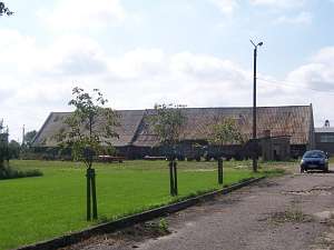 A barn from an old homestead has survived in the
western section of the village. It has a post structure with partially
half-timbered and boarded and partially brick walls and a high double
pitched roof. The barn is one of several preserved buildings of this type
with 4 threshing floors and 5 pairs of double-sided cubbyholes. A barn from an old homestead has survived in the
western section of the village. It has a post structure with partially
half-timbered and boarded and partially brick walls and a high double
pitched roof. The barn is one of several preserved buildings of this type
with 4 threshing floors and 5 pairs of double-sided cubbyholes.
SGKP, t.V, s. 338; Schmid, s.172 - 179, AG IV, Lipińska, t. III, poz. 144.
|
)