|
gm. Miłoradz, pow. malborski, woj. pomorskie
Until 1945 Montau Klein(Endersch, Schrötter, Gotha), Ziegeleinen, Kloszowa,
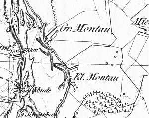
The village was mentioned in 1254 and received a charter in 1321. In 1820, it had 547 residents, including 24 Mennonites. The petition from 1868 was signed by Mennonites from the village: Albrechta, Rahna, Regehra, and Tugahrta. Village layout - flood bank linear village - Kłosowo, Cyganka, and southern Mątowy Małe, short linear village by the eastern road, and colonial village in the eastern section (including a small manor and a park). The cultural landscape has survived in fragments. In 1986, only 3 out of 14 homesteads still existed. The historical houses have been modified. Currently, the majority of old homesteads have modern residential and farming buildings. The homesteads no. 14 and 16 in Cyganek and no. 20 in Mątowy Małe preserved the character of old Dutch homesteads. Other examples of historical architecture include: 4 houses in Kłosowo and Cyganek, a building of an old school, and a house no. 45 in Mątowy Małe dating from the beginning of the 20th century. The arcaded house from 1776 has not survived. A wooden house and brick farming buildings have survived in the homestead no. 32 in Mątowy Małe. The historical field layout in the southern section is difficult to detect.
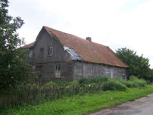 No. 32 is a house erected in the 2nd quarter of the 19th
century and extended at the end of the 19th century. It was probably an
old inn situated in the eastern section of the village, on the southern
side of the road, facing it with its ridge. It has a log structure with
covered quoins, and vertically boarded gables. Initially, the frontal
elevation had 7 axes with a centrally located entrance enclosed by two
narrow windows. It probably used to have a porch or an arcade. At the end
of the 19th century, the eastern wing was added to the corner of the
southern wall adding another entrance in the axis of an earlier
window. No. 32 is a house erected in the 2nd quarter of the 19th
century and extended at the end of the 19th century. It was probably an
old inn situated in the eastern section of the village, on the southern
side of the road, facing it with its ridge. It has a log structure with
covered quoins, and vertically boarded gables. Initially, the frontal
elevation had 7 axes with a centrally located entrance enclosed by two
narrow windows. It probably used to have a porch or an arcade. At the end
of the 19th century, the eastern wing was added to the corner of the
southern wall adding another entrance in the axis of an earlier
window.
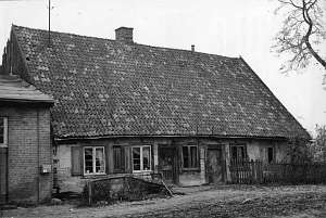 No. 41 was a house/an old inn located by the road to
Miłoradz, facing it with its ridge. It was erected at the turn of the 18th
and 19th centuries. The building had a plastered log structure with
dovetail joints at quoins, boarded gables, a rafter - two-collar beam roof
structure, and ceramic roofing. The 1.5-bay interior had 3 large rooms in
the wider western bay, an entrance directly to the yard, and a row of
smaller rooms in the eastern half-bay (no black kitchen). The southern
elevation had 2 axes, while the southern - 7 axes with entrances in the
3rd and 5th axes from the north. The building no longer exists. No. 41 was a house/an old inn located by the road to
Miłoradz, facing it with its ridge. It was erected at the turn of the 18th
and 19th centuries. The building had a plastered log structure with
dovetail joints at quoins, boarded gables, a rafter - two-collar beam roof
structure, and ceramic roofing. The 1.5-bay interior had 3 large rooms in
the wider western bay, an entrance directly to the yard, and a row of
smaller rooms in the eastern half-bay (no black kitchen). The southern
elevation had 2 axes, while the southern - 7 axes with entrances in the
3rd and 5th axes from the north. The building no longer exists.
Schmid, s. 191- 195, AG IV, MP, Lipińska,t.3- 142
|
)