|
gm. Nowy Staw, pow. malborski, woj. pomorskie
Until 1945 Mierau TK (Schrötter) Myrau (Endersch)
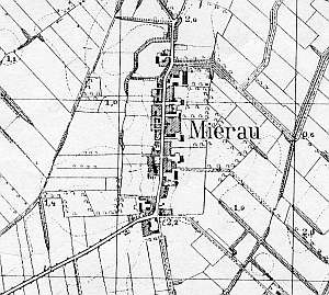
The village was mentioned in 1318 and was granted a charter between 1324 and 1338. The sources from 1776 mentioned the following Mennonite names: Barch, Bestvader, Ens, Epp, Esauł, Claasen, Penner, Wieb, and Wienp. In 1820, the village had 270 residents, including 61 Mennonites. The petition from 1868 was signed by Dück, Dyck, Ens, Suckau, and Wiens from Mirów. In 1860s, the village had 74 włókas and 111 morgas of land, 35 houses, 338 Catholics and Lutherans, and 72 Mennonites. Village layout - a linear village in a north-south line along the Nowy Staw - Tuja road with 4 large farms in the eastern section of the village, and 1-2 in the western section. The cultural landscape is well preserved with 8 Dutch homesteads, 7 wooden houses from the 19th century, and ca. 14 masonry houses from the end of the 19th and beginning of the 20th centuries. Modern buildings are few; they primarily include outbuildings that replaced older buildings. A cobble stone road is lined with old limes. An old field layout and a system of draining canals have survived in the eastern and western sections of the village.
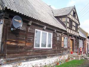 No. 36 is a house from a longitudinal Dutch homestead (a barn
has been demolished; a cowshed is separated from the house by a fire wall;
it has been re-bricked) situated in the northern section of the village,
on the eastern side of a road, facing it with its gable. The house dates
from 1864 and has a log structure with dovetail halvings at corners
(covered by boards imitating Tuscan pilaster), a stone/brick underpinning,
a richly profiled protruding top plate resting on decoratively notched
ceiling beams, a rafter - two-collar beam roof structure, asbestos tile
roofing, and a half-timbered extension in the southern roof slope. The
ground floor and the window arrangement have been modified. The western
elevation has 4 axes with two windows enclosed by narrow windows
(topped by triangular shapes) and a semicircular skylight above. The
southern elevation has 6 axes and an entrance with a decorative door in
the 3rd axis from the east and a 2-axial attic room above the
entrance. No. 36 is a house from a longitudinal Dutch homestead (a barn
has been demolished; a cowshed is separated from the house by a fire wall;
it has been re-bricked) situated in the northern section of the village,
on the eastern side of a road, facing it with its gable. The house dates
from 1864 and has a log structure with dovetail halvings at corners
(covered by boards imitating Tuscan pilaster), a stone/brick underpinning,
a richly profiled protruding top plate resting on decoratively notched
ceiling beams, a rafter - two-collar beam roof structure, asbestos tile
roofing, and a half-timbered extension in the southern roof slope. The
ground floor and the window arrangement have been modified. The western
elevation has 4 axes with two windows enclosed by narrow windows
(topped by triangular shapes) and a semicircular skylight above. The
southern elevation has 6 axes and an entrance with a decorative door in
the 3rd axis from the east and a 2-axial attic room above the
entrance.
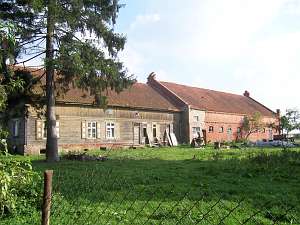
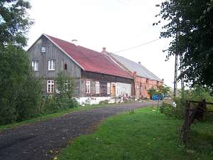 No. 34 is a longitudinal Dutch homestead with a
slightly higher cowshed from beginning of the 20th century (a barn has
been taken down). The homestead is situated in the central section of the
village on the eastern side, facing the road with the ridge. The house
dates from the 4th quarter of the 19th century. It has a corner-notched
log structure with quoins covered by boards imitating Tuscan pilaster, a
stone/brick underpinning, a vertically boarded pointing sill and a gable,
a queen post - purlin roof structure with an angle brace, and asbestos
tile roofing. The western elevation has 3 axes. The western gable has 4
axes, two windows enclosed by small and narrow skylights (topped by
triangular shapes) and a doubled form of the side skylight above. The
southern elevation has 6 axes with an entrance located in the 3rd axis
from the east. No. 34 is a longitudinal Dutch homestead with a
slightly higher cowshed from beginning of the 20th century (a barn has
been taken down). The homestead is situated in the central section of the
village on the eastern side, facing the road with the ridge. The house
dates from the 4th quarter of the 19th century. It has a corner-notched
log structure with quoins covered by boards imitating Tuscan pilaster, a
stone/brick underpinning, a vertically boarded pointing sill and a gable,
a queen post - purlin roof structure with an angle brace, and asbestos
tile roofing. The western elevation has 3 axes. The western gable has 4
axes, two windows enclosed by small and narrow skylights (topped by
triangular shapes) and a doubled form of the side skylight above. The
southern elevation has 6 axes with an entrance located in the 3rd axis
from the east.
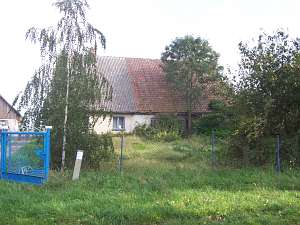 No. 32 is a house from an old Dutch
homestead (farming buildings have been taken down) situated in the village
center, on the eastern side of a road, facing it with its ridge. The house
dates from the 3rd quarter of the 19th century. It has a log structure
with quoins covered by boards imitating Tuscan pilaster, a rafter -
two-collar beam roof structure, a brick underpinning, and partially
pantile and partially asbestos tile roofing. The northern section of the
house has been bricked. The southern elevation has 3 axes, a 2-axial gable
at the lower level, and a single window above. The western elevation
originally had 6 axes with an entrance in the 3rd axis from the
east. No. 32 is a house from an old Dutch
homestead (farming buildings have been taken down) situated in the village
center, on the eastern side of a road, facing it with its ridge. The house
dates from the 3rd quarter of the 19th century. It has a log structure
with quoins covered by boards imitating Tuscan pilaster, a rafter -
two-collar beam roof structure, a brick underpinning, and partially
pantile and partially asbestos tile roofing. The northern section of the
house has been bricked. The southern elevation has 3 axes, a 2-axial gable
at the lower level, and a single window above. The western elevation
originally had 6 axes with an entrance in the 3rd axis from the
east.
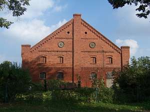 No. 14 is farming complex from the beginning of the 20th
century situated in the village center, on the eastern side of the road.
It includes a brick house and two long farming/livestock buildings. A
cowshed with a storage section on the upper floor is situated along the
northern side of the yard. Its brick walls cover an internal wooden
structure. The gable elevation has 4 axes, 2 levels, and windows topped by
segmented arches with brick friezes, a block cornice, and concrete plates
with six-pointed stars. No. 14 is farming complex from the beginning of the 20th
century situated in the village center, on the eastern side of the road.
It includes a brick house and two long farming/livestock buildings. A
cowshed with a storage section on the upper floor is situated along the
northern side of the yard. Its brick walls cover an internal wooden
structure. The gable elevation has 4 axes, 2 levels, and windows topped by
segmented arches with brick friezes, a block cornice, and concrete plates
with six-pointed stars.
  No. 27 was a wooden house from
ca. 1850. It had a log structure with quoins covered by boards imitating
rustication and a half-timbered arcade supported by 6 posts and a
half-timbered wall. The interior had a 2.5-bay layout with bays
separated by a corridor. There were 3 entrances: from the arcade side,
from the yard side, and from the gable wall side. The building has been
taken down. No. 27 was a wooden house from
ca. 1850. It had a log structure with quoins covered by boards imitating
rustication and a half-timbered arcade supported by 6 posts and a
half-timbered wall. The interior had a 2.5-bay layout with bays
separated by a corridor. There were 3 entrances: from the arcade side,
from the yard side, and from the gable wall side. The building has been
taken down.
SGKP, t.V, s. 499, Lipińska, t.III, poz. 194; AG IV, BF
|
)