|
gm. Nowy Staw, pow. malborski, woj. pomorskie
Until 1945 Niedau (Gotha, Endersch, Schrötter)
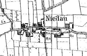
The village received privileges in 1356. The sources from 1776 mentioned the following Mennonites surnames: Dick, Claassen, and Wall. In 1820, the village had 169 residents, including 24 Mennonites. Village layout - linear and square village in an east - west line with 3 large farms in the northern section and 3 in the southern section of the village. The cultural landscape of the village has partially survived with a spatial layout, homesteads, rows of old trees lining roads, a lime alley, several old trees around homesteads, a field layout, and a road system. Historical buildings have been partially replaced (traditional location preserved). A considerable number of farming buildings have been taken down.
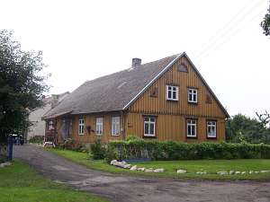
No. 1 is a longitudinal Dutch homestead situated in a colony,
in the eastern section of the village, ca. 100 m from the road, facing it
with its ridge. The homestead includes a wooden house and a modern,
brick cowshed and a barn. The house was erected in the 1st quarter of the
19th century and has a log structure, a vertically boarded gable and a
porch in front of the long wall. The house has been partially modified.
There is a vertically boarded, half-timbered granary (with a two-gate
coach house) in the southeastern section of the yard.
 No. 15 is a
house from an old Dutch homestead situated in the western section of the
village, facing a road with its gable. The building dates from the
beginning of the 19th century and has a log structure, a vertically
boarded gable, and a long, 7-axial wall with a porch added later in the
axes 2-4 from the south. No. 15 is a
house from an old Dutch homestead situated in the western section of the
village, facing a road with its gable. The building dates from the
beginning of the 19th century and has a log structure, a vertically
boarded gable, and a long, 7-axial wall with a porch added later in the
axes 2-4 from the south.
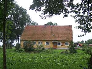 No. 6 is a house from an old Dutch
homestead situated on the southern side of a road, facing it with its
ridge. It has a log structure, a vertically boarded gable, a long 7-axial
ridge wall, and a 3-axial gable wall. A barn and a cowshed have been
demolished. A half-timbered granary has survived in the southern section
of the yard. No. 6 is a house from an old Dutch
homestead situated on the southern side of a road, facing it with its
ridge. It has a log structure, a vertically boarded gable, a long 7-axial
ridge wall, and a 3-axial gable wall. A barn and a cowshed have been
demolished. A half-timbered granary has survived in the southern section
of the yard.
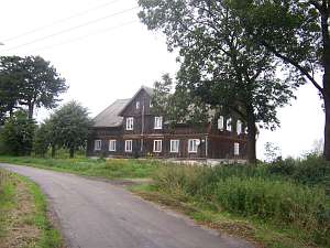 No. 10 is a detached house situated in the eastern
section of the village, on the northern side of the road, facing it with
its ridge. It is an old arcaded house erected probably in the 4th quarter
of the 18th century and modified in the 3rd - 4th quarters of the 19th
century. It is a single-storey building with a log structure, a
half-timbered attic room and gables, a high pointing sill, 7 axes, and a
4-axial gable wall. The entire house is vertically boarded (with slats).
Originally, the house had an arcade located in central axes. It has been
reduced to a wide attic room. A cornice and carved wind ties with
decorative profiles have survived. No. 10 is a detached house situated in the eastern
section of the village, on the northern side of the road, facing it with
its ridge. It is an old arcaded house erected probably in the 4th quarter
of the 18th century and modified in the 3rd - 4th quarters of the 19th
century. It is a single-storey building with a log structure, a
half-timbered attic room and gables, a high pointing sill, 7 axes, and a
4-axial gable wall. The entire house is vertically boarded (with slats).
Originally, the house had an arcade located in central axes. It has been
reduced to a wide attic room. A cornice and carved wind ties with
decorative profiles have survived.
Lipińska, t. III, poz. 197; AG, BF
|
)