|
gm. Markusy, pow. elbląski, woj. warmińsko - mazurskie
Until 1945, Neu Dollstädt TK (Schrötter)

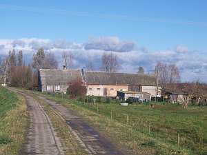
The village was founded in 1631 by Dutch colonists. Village layout - a row village on terpy, a flood bank linear village on the eastern bank of the Dzierzgoń river, and a water linear village on the western bank of the Drzerzgonka. The cultural landscape has survived in the flood bank section of the village. In 1980s, the village had ca. 10 Dutch homesteads, including 6 wooden and 2 arcaded houses from the 19th century. There is an area of colonial houses from 1930s in the eastern section of the village. Settlements of the colonial type are disappearing (only terpy have remained) and Dutch homesteads are being transformed by replacing building materials (only general layout remains). A field layout, a system of draining canals, and partially, homestead vegetation have survived.
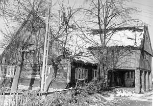  No. 4 was an arcaded house from an old longitudinal Dutch
homestead situated on the eastern side of the road to Stankowo, facing it
with its gable. The building was erected at the end of the 18th century on
a stone foundation. It had a log structure with quoins covered by boars
carved into a profile of a high baluster, a vertically boarded,
half-timbered arcade (south side), a vertically boarded gable, a rafter -
collar beam roof structure, a thatched roof, and a bullseye in the
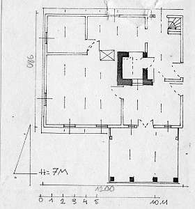
northern roof slope. The interior had a 1.5-bay layout with the large room
in the southwestern corner, a black kitchen in the large room bay, and two
separate hallways. The gable elevation had 2 axes and a single-axial gable
with a semicircular skylight above a single window. The frontal elevation
had 5 axes, an entrance between narrow windows in the 2nd axis from the
south, and an arcade in the axes 1-3 from the north. The building has been
taken down.lt;br> No. 4 was an arcaded house from an old longitudinal Dutch
homestead situated on the eastern side of the road to Stankowo, facing it
with its gable. The building was erected at the end of the 18th century on
a stone foundation. It had a log structure with quoins covered by boars
carved into a profile of a high baluster, a vertically boarded,
half-timbered arcade (south side), a vertically boarded gable, a rafter -
collar beam roof structure, a thatched roof, and a bullseye in the
northern roof slope. The interior had a 1.5-bay layout with the large room
in the southwestern corner, a black kitchen in the large room bay, and two
separate hallways. The gable elevation had 2 axes and a single-axial gable
with a semicircular skylight above a single window. The frontal elevation
had 5 axes, an entrance between narrow windows in the 2nd axis from the
south, and an arcade in the axes 1-3 from the north. The building has been
taken down.lt;br>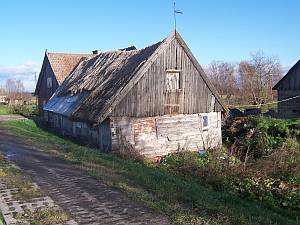 No. 17 is a house from an old longitudinal Dutch
homestead (farming buildings have been taken down, the northern part -
transformed) from the beginning of the 19th century facing the flood bank
with its ridge. It has a partially log and partially brick structure,
vertically boarded gables, a rafter roof structure, and a thatched roof.
The gable elevation has 2 axes. No. 17 is a house from an old longitudinal Dutch
homestead (farming buildings have been taken down, the northern part -
transformed) from the beginning of the 19th century facing the flood bank
with its ridge. It has a partially log and partially brick structure,
vertically boarded gables, a rafter roof structure, and a thatched roof.
The gable elevation has 2 axes.
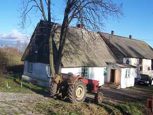 No. 20 is a longitudinal Dutch
homestead. It faces the flood bank with its gable. A cowshed and a barn
are modern. A house from the mid 19th century has survived. It has a
plastered log structure, a vertically boarded gable, and a double-pitched
roof covered by asbestos tiles. No. 20 is a longitudinal Dutch
homestead. It faces the flood bank with its gable. A cowshed and a barn
are modern. A house from the mid 19th century has survived. It has a
plastered log structure, a vertically boarded gable, and a double-pitched
roof covered by asbestos tiles.
 No. 18 is a longitudinal Dutch
homestead. It faces the flood bank with its gable. A cowshed and a barn
are modern. A house dates from the mid 19th century and has a plastered
log structure with covered quoins, a vertically boarded gable, and a
double-pitched roof covered by asbestos tiles. No. 18 is a longitudinal Dutch
homestead. It faces the flood bank with its gable. A cowshed and a barn
are modern. A house dates from the mid 19th century and has a plastered
log structure with covered quoins, a vertically boarded gable, and a
double-pitched roof covered by asbestos tiles.
Lipińska, t. III, poz. 127
|
)