|
gm. Nowy Dwór Gdański, pow. nowodworski, woj. pomorskie
Until 1945 Orloff TK (Endersch, Schrötter)
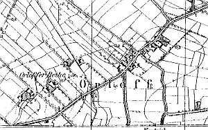
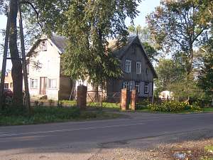
The village was established in 1349 by the Grand Commander, Heinrich Tusemer under the Chełmno law. At the time, the village had 48 włókas. Dutch settlers arrived in 1550 and a settlement of Ormowskie Pole was sectioned off from Orłowo, which retained 18 włókas of land. In 1727, the village had 12 Mennonites, in 1772 - 13. The sources from 1776 mentioned the following surnames: Dick, Fast, Haman, Lepp, Neufeld, Penner, Quiring, Reimer, Rigehr, Schultz, Suckau, Thiessen, and Wieb. In 1820, the village had 145 residents, including 84 Mennonites. The petition from 1868 from Orłowo was signed by Aaron Claasen, the merchant, J. Ran, and Abraham Unger. Village layout - partially, a linear village in a north-south line along the Lubieszew - Nowy Dwór road and partially a colonial village on terpy. The cultural landscape of the village is in decline with an undetectable spatial layout. The examples of the historical architecture include: a Gothic St. Jacob church, 5-6 wooden houses from the 19th century, two Dutch homesteads, and several masonry houses from the beginning of the 20th century. The road to Lubieszewo and internal village roads retain their cobble stone surfaces and rows of old linden trees lining the edges. The cemetery surrounding the church has no gravestones. Homestead vegetation, a field layout, and a system of draining canals have survived.
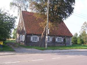
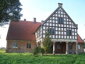 No. 1 is an arcaded house erected in 1802 by Peter Loeven for
Cornelius Jansson. It is situated in the colony, in the southern section
of the village and has a stone underpinning, a log structure with boarded
quoins, a deep, half-timbered arcade (south side) supported by 8 columns
(4 in the frontal row) in the Ionian order, a small porch (north side)
supported by 4 wooden posts, vertically boarded gables, a queen post -
purlin roof structure (build-up in the lower section), and a ceramic roof.
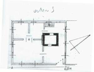
The interior has a 2-bay layout with a wide eastern bay, the large room in
the southeastern corner, a black kitchen in the large room bay, and
two separated hallways - an arcade hallway and a Z-shaped, utility hallway
with a build-up staircase in the northeastern corner. The southern
elevation has 7 axes with an entrance between two windows in the 4th axis
and a 2-axial arcade with richly decorated column heads, carved beam ends,
and an entrance portal. Entrance and internal doors as well as cabinets
have survived. The house is being renovated. No. 1 is an arcaded house erected in 1802 by Peter Loeven for
Cornelius Jansson. It is situated in the colony, in the southern section
of the village and has a stone underpinning, a log structure with boarded
quoins, a deep, half-timbered arcade (south side) supported by 8 columns
(4 in the frontal row) in the Ionian order, a small porch (north side)
supported by 4 wooden posts, vertically boarded gables, a queen post -
purlin roof structure (build-up in the lower section), and a ceramic roof.
The interior has a 2-bay layout with a wide eastern bay, the large room in
the southeastern corner, a black kitchen in the large room bay, and
two separated hallways - an arcade hallway and a Z-shaped, utility hallway
with a build-up staircase in the northeastern corner. The southern
elevation has 7 axes with an entrance between two windows in the 4th axis
and a 2-axial arcade with richly decorated column heads, carved beam ends,
and an entrance portal. Entrance and internal doors as well as cabinets
have survived. The house is being renovated.
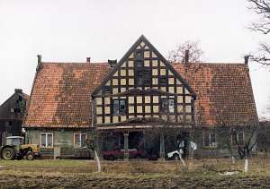  No. 2 is a house
erected in 1802 by Peter Loeven for Cornelius Froese. It is situated in
the colony, in the southern section of the village, on the western side of
the road (ca. 100 m from it), facing it with its ridge. The building has a
brick underpinning, a log structure with quoins covered by boards
imitating Tuscan pilaster, vertically boarded gables, and a half-timbered
extension supported by 4 frontal and 6 side stylized Ionian columns. The
interior has a 2-bay layout with similar bays, the large room in the
southeastern corner, a central black kitchen, and 2 separated hallways - a
rectangular, arcaded hallway and an L-shaped utility hallway, which
separates a summer room and utility spaces in the northern section of the
house. The building has rich architectural detail with decorated columns
of the arcade, cornices, door frames, acroterions, and cabinets inside. A
wooden granary/coach house has also survived.& No. 2 is a house
erected in 1802 by Peter Loeven for Cornelius Froese. It is situated in
the colony, in the southern section of the village, on the western side of
the road (ca. 100 m from it), facing it with its ridge. The building has a
brick underpinning, a log structure with quoins covered by boards
imitating Tuscan pilaster, vertically boarded gables, and a half-timbered
extension supported by 4 frontal and 6 side stylized Ionian columns. The
interior has a 2-bay layout with similar bays, the large room in the
southeastern corner, a central black kitchen, and 2 separated hallways - a
rectangular, arcaded hallway and an L-shaped utility hallway, which
separates a summer room and utility spaces in the northern section of the
house. The building has rich architectural detail with decorated columns
of the arcade, cornices, door frames, acroterions, and cabinets inside. A
wooden granary/coach house has also survived.&
 No. 17 (27) is a
house from a Dutch homestead (farming buildings have been partially
demolished) erected in the 3rd quarter of the 19th century and modified in
1910. It is situated in the southern section of the village, on the
western side of a road, facing it with its gable. It is a single-storey
wooden building with a low pointing sill, a stone underpinning, a log
structure with quoins covered by boards imitating Tuscan pilaster, a
vertically boarded gable, a small, half-timbered extension supported by 4
posts, a (currently) built-up arcade, a queen post - purlin roof structure
with an angle brace, and asbestos tile roofing. The interior has a 2-bay
layout with the large room in the southeastern corner, a centrally
located black kitchen, and two hallways, which separate the western
farming section. The gable elevation has 4 axes, a 4-axial gable (bottom
section), two windows enclosed by narrow windows topped by segmented
arches, and a repeated form of the side windows above. The finial between
wind ties is decorated with fretwork. The southern elevation has 7 axes
and the 2-axial extension above the arcade (in front of an entrance) in
the axes 3-5 from the west. No. 17 (27) is a
house from a Dutch homestead (farming buildings have been partially
demolished) erected in the 3rd quarter of the 19th century and modified in
1910. It is situated in the southern section of the village, on the
western side of a road, facing it with its gable. It is a single-storey
wooden building with a low pointing sill, a stone underpinning, a log
structure with quoins covered by boards imitating Tuscan pilaster, a
vertically boarded gable, a small, half-timbered extension supported by 4
posts, a (currently) built-up arcade, a queen post - purlin roof structure
with an angle brace, and asbestos tile roofing. The interior has a 2-bay
layout with the large room in the southeastern corner, a centrally
located black kitchen, and two hallways, which separate the western
farming section. The gable elevation has 4 axes, a 4-axial gable (bottom
section), two windows enclosed by narrow windows topped by segmented
arches, and a repeated form of the side windows above. The finial between
wind ties is decorated with fretwork. The southern elevation has 7 axes
and the 2-axial extension above the arcade (in front of an entrance) in
the axes 3-5 from the west.
A wooden granary has also
survived.
  No. 12 (19) is a house from an old Dutch homestead
(farming buildings have been taken down) situated in the village center,
on the western side of the road, facing it with its ridge. The house dates
from the mid 19th century and has a brick underpinning, a log structure
with quoins covered by boards imitating Tuscan pilaster, a vertically
boarded gable, and pantile roofing. The gable elevation has 3 axes and a
2-level gable with 4 axes at the lower level with two wide windows
enclosed by smaller windows and a rectangular skylight topped by a
segmented arch above. The eastern elevation has 4 axes with an entrance in
the northern axis. Decorative elements of the building have survived -
profiled, protruding top plate resting on notched beams, frame - panel
shutters, and a double-leafed entrance door. No. 12 (19) is a house from an old Dutch homestead
(farming buildings have been taken down) situated in the village center,
on the western side of the road, facing it with its ridge. The house dates
from the mid 19th century and has a brick underpinning, a log structure
with quoins covered by boards imitating Tuscan pilaster, a vertically
boarded gable, and pantile roofing. The gable elevation has 3 axes and a
2-level gable with 4 axes at the lower level with two wide windows
enclosed by smaller windows and a rectangular skylight topped by a
segmented arch above. The eastern elevation has 4 axes with an entrance in
the northern axis. Decorative elements of the building have survived -
profiled, protruding top plate resting on notched beams, frame - panel
shutters, and a double-leafed entrance door.
No. 28 is a house
from a longitudinal Dutch homestead (farming buildings - demolished)
situated in the southwestern colony. It dates form ca. 1890 and has a
brick underpinning, a log structure with quoins covered by boards
imitating Tuscan pilaster, a vertically boarded pointing sill and a gable,
a queen post - purlin roof structure with an angle brace, and pantile
roofing. The interior has a 2-bay layout with similar bays, the large room
in the southwestern corner, a centrally located black kitchen, and an
L-shaped, bipartite hallway. The gable elevation has 3 axes and a 2-level
gable with 4 axes at the bottom, two wide windows enclosed by two
skylights topped by triangular shapes, and a doubled skylight above. The
frontal elevation has 6 axes with an entrance in the 3rd axis from the
north.
No. 30/31 is a house from a longitudinal Dutch homestead
(farming buildings - demolished) situated in the southwestern colony. It
dates form ca. 1890 and has a brick underpinning, a log structure
with quoins covered by boards imitating Tuscan pilaster, a vertically
boarded pointing sill and a gable, a queen post - purlin roof structure
with an angle brace, and pantile roofing. The interior has a 2-bay layout
with similar bays, the large room in the southwestern corner, a centrally
located black kitchen, and an L-shaped, open hallway connected with a
cowshed by a corridor. The gable elevation has 3 axes and a 2-level gable
with 4 axes at the bottom, two wide windows enclosed by two
quarter-circular skylights, and a semicircular skylight above. The frontal
elevation has 6 axes with an entrance in the 3rd axis from the
north.
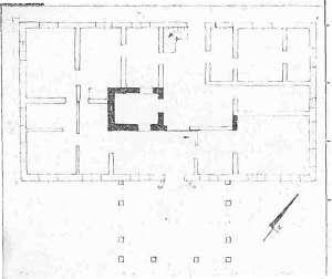
No. 33 is the Jakub Schulte's arcaded house from 1798
erected by Gerhardt Hildebrant. It was a part of a Dutch homestead
(farming buildings - replaced). The building burned down in 1957, but was
rebuilt at the beginning of the 1960s. The house is separated from a
cowshed by a high fire wall. It is situated in a colony, in the southern
section of the village. It has a log structure with boarded quoins, a deep
half-timbered arcade supported by 6 posts and half-timbered walls, and a
vertically boarded gable and extensions. The interior has a 2-bay layout
with a wide eastern bay, a divided (later) large room in the southeastern
corner, a black kitchen in the large room bay, and a Z-shaped
hallway with stairs to a cellar and to an attic (by the yard door). The
eastern elevation has 6 axes and an entrance between two windows in the
3rd axis. The building has a two-window extension above the post
arcade.
No. 37/38 is a house from a longitudinal Dutch homestead
(farming buildings - partially demolished) situated in the southwestern
colony. It dates form the end of the 18th century and has a brick
underpinning, a log structure with quoins covered by boards imitating
Tuscan pilaster, a vertically boarded gable, pantile roofing, and a hipped
roof arcade on the western side. The interior has a 2-bay layout with
similar bays, the large room in the southeastern corner, and two separated
hallways - a rectangular stylish hallway and a utility hallway, which is
connected to a cowshed by a corridor. The gable elevation has 3 axes and a
2-level gable with 3 axes and a single window above. The frontal elevation
has 6 axes. A wooden granary is located in the yard.
 There are
scattered remains of Mennonite gravestones (Joann Fast, among others) in
the church cemetery There are
scattered remains of Mennonite gravestones (Joann Fast, among others) in
the church cemetery
Schmid, s. 241-245; ME, t. III, s. 309, Lipińska t. III, poz. 67; AG IV; MP, BF.
|
)