|
gm. Nowy Dwór Gdański, pow. nowodworski, woj. pomorskie
Until 1945 Orloffelde TK (Orloffeld - Schrötter)
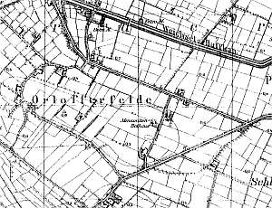
The village was established in 1526. Between 1550 and 1629, the village was included in the Dutch colonization. Orłowskie Pole had the oldest Mennonite community - established in 1562. In 1751, the Mennonites erected a wooden house of prayer. The Orłowska community belonged to the Frisian sect and was under the authority of the Lubieszewo community. In 1882, the local community merged with the Lubieszewo community, but the villages retained their own pastors. The sources from 1776 mentioned the following names: Dircksen, Froese, Gebrand, Gruntu, Harms, Jantzen, Jopp, Nickel, Quiring, Schroeder, and Unger. In 1820, the village had 169 residents, including 89 Mennonites. The petition from 1868 was signed by Johann Klingenberg. Village layout - a linear village in a north-south line along the Lubieszew - Nowy Dwór road and partially a colonial village on terpy. The cultural landscape has been severely modified partially by the construction of a state farm housing development and road construction projects. The village is slowly becoming a part of Orłowo. In 1986, surveyors found 9 historical buildings in 15 old homesteads. Only several of those buildings have survived to the present day. Historical architecture is being supplanted by modern building with the style unrelated to local traditions. The Mennonite cemetery has recently been cleaned up. Old gravestones have been placed in a lapidarium. A church from 1751 was taken down after 1945. A field layout, a system of draining ditches, and several terpy are still detectable.
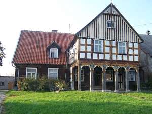 No. 1 is a Dutch homestead of the longitudinal type situated
in the eastern section of the village, behind the houses of the former
state farm. The homestead consists of an arcaded house and a slightly
higher brick cowshed, which is separated from the house by a high fire
wall. A barn and a granary, which was located in the southeastern section
of the yard, have been demolished (granary - 2005). The house has a stone
underpinning, a log structure with boarded quoins, a deep, half-timbered
arcade (east side) supported by 6 wooden posts and a half-timbered wall, a
vertically boarded gable and an arcade, a queen post - purlin roof
structure (built-up lower section), and a ceramic roof. The southern
elevation has 6 axes with an entrance between two windows in the 3rd axis
from the north and a 2-axial arcade. Decorated angle braces in the arcade,
fretwork between wind ties, and a Mennonite pazdur in the arcade finial
have survived. No. 1 is a Dutch homestead of the longitudinal type situated
in the eastern section of the village, behind the houses of the former
state farm. The homestead consists of an arcaded house and a slightly
higher brick cowshed, which is separated from the house by a high fire
wall. A barn and a granary, which was located in the southeastern section
of the yard, have been demolished (granary - 2005). The house has a stone
underpinning, a log structure with boarded quoins, a deep, half-timbered
arcade (east side) supported by 6 wooden posts and a half-timbered wall, a
vertically boarded gable and an arcade, a queen post - purlin roof
structure (built-up lower section), and a ceramic roof. The southern
elevation has 6 axes with an entrance between two windows in the 3rd axis
from the north and a 2-axial arcade. Decorated angle braces in the arcade,
fretwork between wind ties, and a Mennonite pazdur in the arcade finial
have survived.
No. 41 is a house from a longitudinal Dutch
homestead situated in the northern colony. It was erected ca. 1860 and has
a brick underpinning, a log structure with quoins covered by boards
imitating Tuscan pilaster, a vertically boarded pointing sill and a gable,
a queen post - purlin roof structure with an angle brace, and pantile
roofing. The interior has a 1.5-bay layout with the large room in the
southeastern corner, a black kitchen in the large room bay, and two
separate hallways. The gable elevation has 3 axes and a two-level gable
with 4 axes at the lower level. The frontal elevation has 5 axes with an
entrance (with a porch) in the 2nd axis from the south.
No. 46
is a house from a longitudinal Dutch homestead (farming buildings -
demolished) situated in the southwestern colony. It dates form ca. 1890
and has a brick underpinning, a log structure with quoins covered by
boards, a vertically boarded pointing sill and a gable, a queen post -
purlin roof structure with an angle brace, and pantile roofing. The
interior has similar bays with the large room in the southeastern corner,
a centrally located black kitchen, and an reversed-C-shaped hallway. The
gable elevation has 3 axes and a 2-level gable (4 axes at the bottom) with
two wide windows enclosed by two quarter-circular skylights and a
semicircular skylight above. The frontal elevation has 5 axes with an
entrance in the 2nd axis from the north.
No. 48 is a house from a
longitudinal Dutch homestead (farming buildings separated by a high fire
wall have been demolished) situated in the southwestern colony. It was
erected in 1907 (probably in place of an older building) and has a brick
underpinning, a log structure with quoins covered by boards imitating
Tuscan pilaster, a vertically boarded pointing sill and a gable, an attic
room in the eastern roof slope, a queen post - purlin roof structure with
an angle brace, and pantile roofing. The interior has a 1.5-bay layout
with the large room in the southwestern corner, a black kitchen in the
large room bay, and an open, L-shaped hallway. The gable elevation has 3
axes and a 2-level gable (4 axes at the bottom) with two wide windows
enclosed by two skylights topped by triangular shapes and a doubled form
of the skylight above. The frontal elevation has 5 axes with an entrance
in the 2nd axis from the north.
No. 30/31 was a house from a
longitudinal Dutch homestead situated in the northern colony near the
Mennonite cemetery. It was erected ca. 1790 and modified in the 3rd
quarter of the 19th century. The building had a brick underpinning, a log
structure with quoins covered by boards imitating Tuscan pilaster, a
vertically boarded gable, a rafter - collar beam roof structure, and
pantile roofing. The interior had a 1.5-bay layout with the large room in
the northwestern corner, a black kitchen in the large room bay, and two
separate hallways: a rectangular elegant hallway and an L-shaped hallway,
which was connected to a cowshed by a corridor. The gable elevation had 3
axes, a 2-level gable with 4 axes at the bottom, two wide windows enclosed
by two skylights topped by triangular shapes, and a doubled form of the
skylight above. The frontal elevation had 6 axes with an entrance in the
3rd axis from the south. The building no longer exists.
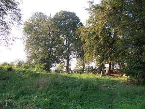 The
Mennonite cemetery is situated in the northern section of the village, on
the western side. It has a rectangular layout with preserved arrangement
of sections and remains of a Bethhaus foundation in the southeastern
section. Some old trees have been cut down; the cemetery still has dozen
or so gravestones including: 10 stalls and 3 cippuses with the surnames:
Albrecht, Huger, Dyck, Dück, and Penner. The graves of Peter Stobbe from
Nowy Dwór, Joann Donner, Cornelius Lepp, and Kornelia Schroeder, née
Quiring were located in the cemetery until 1945. The
Mennonite cemetery is situated in the northern section of the village, on
the western side. It has a rectangular layout with preserved arrangement
of sections and remains of a Bethhaus foundation in the southeastern
section. Some old trees have been cut down; the cemetery still has dozen
or so gravestones including: 10 stalls and 3 cippuses with the surnames:
Albrecht, Huger, Dyck, Dück, and Penner. The graves of Peter Stobbe from
Nowy Dwór, Joann Donner, Cornelius Lepp, and Kornelia Schroeder, née
Quiring were located in the cemetery until 1945.
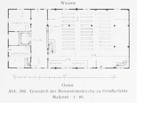 The Mennonite
church was erected in 1751 and had a log structure with quoins covered by
boards imitating rustication, vertically boarded half-timbered gables, a
queen post - purlin roof structure, and pantile roofing. The church had a
rectangular layout with a hallway (running across the entire width) that
separated a nave from a pastor's apartment. Galleries supported by columns
were located along three walls. The eastern elevation had 7 axes. The
southern elevation also had 7 axes with 4 axes at the lower level and an
entrance in the 2nd axis from the east. The Mennonite
church was erected in 1751 and had a log structure with quoins covered by
boards imitating rustication, vertically boarded half-timbered gables, a
queen post - purlin roof structure, and pantile roofing. The church had a
rectangular layout with a hallway (running across the entire width) that
separated a nave from a pastor's apartment. Galleries supported by columns
were located along three walls. The eastern elevation had 7 axes. The
southern elevation also had 7 axes with 4 axes at the lower level and an
entrance in the 2nd axis from the east.
Schmid, s.145-146; ME, t. III, s. 310, Lipińska t. III, poz. 168; AG IV; MP, BF, Warchoł.
|
)