|
gm. Ostaszewo, pow. malborski, woj. pomorskie
Until 1945 Palschau (Endersch, Schrötter), Palschaus (Gotha),
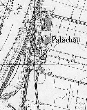
The village was associated with the Vistula river crossing. It was mentioned in 1321 and received privileges in 1344. The sources from 1776 mentioned the following Mennonite surnames: Konrad, Dick, Ens, and Claassen. In 1820, the village had 289 residents, including 31 Mennonites. The petition from 1868 was signed by Claasen, Peter Dau, Isaak Dyck, Adolf and Jakob Harder, J. Rogalsky, Wiebe, Wiens (landowners), and Joann Nickel (a merchant). Village layout - a single sided linear village and a flood bank linear village. The cultural landscape of the village has been preserved in the large part with a detectable spatial layout and homesteads. Examples of historical architecture include the Częstochowska Mother of God wooden church from 1712, a half-timbered house from the end of the 18th century, 3 wooden houses from the end of the 19th century, a Dutch windmill, 8 - 10 brick buildings from the end of the 19th century and the 1st quarter of the 20th century, and outbuildings. Some of the buildings are decorated with religious symbols. There is an old cemetery with old trees and contemporary graves. Buildings located by the flood bank have been transformed. A field layout and a system of draining ditches have survived.
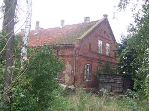 No. 61 is a house situated in a colony, on the eastern side
of the road to Boręty, facing it with its ridge. The building was erected
in 1895 for an owner with initials C.F. It is a single storey, brick
building resting on a brick underpinning and has a pointing sill and a
double-pitched, ceramic roof. The gable elevation has 4 axes, a 4-axial
gable, and two windows enclosed by narrow skylights. Above, there are cast
plates with six-pointed stars and a centrally located circular skylight.
Brick elevations have various forms of brick cornices and heavy pinnacles
in corners and gable finials. The western elevation has 5 axes and an
entrance located in the 3rd axis from the south decorated by six-pointed
stars. The homestead also has a partially preserved outbuilding, which
functioned as a cowshed, a granary, and a coach house. It is a brick
building with rich architectural detail. In addition to the owner's
initials and the building completion date, the western elevation has a
motif of a six-pointed star made of bricks. No. 61 is a house situated in a colony, on the eastern side
of the road to Boręty, facing it with its ridge. The building was erected
in 1895 for an owner with initials C.F. It is a single storey, brick
building resting on a brick underpinning and has a pointing sill and a
double-pitched, ceramic roof. The gable elevation has 4 axes, a 4-axial
gable, and two windows enclosed by narrow skylights. Above, there are cast
plates with six-pointed stars and a centrally located circular skylight.
Brick elevations have various forms of brick cornices and heavy pinnacles
in corners and gable finials. The western elevation has 5 axes and an
entrance located in the 3rd axis from the south decorated by six-pointed
stars. The homestead also has a partially preserved outbuilding, which
functioned as a cowshed, a granary, and a coach house. It is a brick
building with rich architectural detail. In addition to the owner's
initials and the building completion date, the western elevation has a
motif of a six-pointed star made of bricks.
 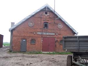 No. 28 is a house
situated in the southern section of the village, on the eastern side of a
road, facing it with its ridge. It consists of two sections: an older
northern section dating from the mid 19th century and a southern section
added at the end of the 19th century or at the beginning of the 20th
century. Until 1945, the building belonged to Hans Harde. The northern
section has one storey and rests on a stone underpinning, while the
southern section - 1.5 stories and a brick underpinning. The house has a
log structure (northern section), a pointing sill (southern section),
vertically boarded gables, and asbestos tile roofing. The northern
elevation has 3 axes and a 1-axial gable. The southern elevation has 2
axes and a 4-axial gable. The western elevation is irregular with 6 axes
and shifted window axes in the pointing sill. Wooden architectural details
have partially survived with window frames and notched rafters. There is a
partially preserved brick cowshed from 1921 with rich architectural
detail. In addition to the owner's initials and the building completion
date, the western elevation has cast plates with eight-pointed stars and a
six-pointed star in the finial. No. 28 is a house
situated in the southern section of the village, on the eastern side of a
road, facing it with its ridge. It consists of two sections: an older
northern section dating from the mid 19th century and a southern section
added at the end of the 19th century or at the beginning of the 20th
century. Until 1945, the building belonged to Hans Harde. The northern
section has one storey and rests on a stone underpinning, while the
southern section - 1.5 stories and a brick underpinning. The house has a
log structure (northern section), a pointing sill (southern section),
vertically boarded gables, and asbestos tile roofing. The northern
elevation has 3 axes and a 1-axial gable. The southern elevation has 2
axes and a 4-axial gable. The western elevation is irregular with 6 axes
and shifted window axes in the pointing sill. Wooden architectural details
have partially survived with window frames and notched rafters. There is a
partially preserved brick cowshed from 1921 with rich architectural
detail. In addition to the owner's initials and the building completion
date, the western elevation has cast plates with eight-pointed stars and a
six-pointed star in the finial.
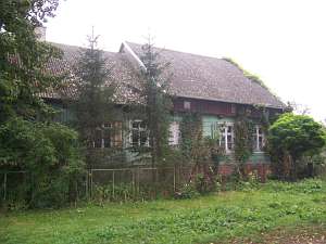
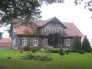 No. 12 is a house situated in a
colony, in the eastern section of the village, on the northern side of the
road to Pordenów, facing it with its ridge. The building dates from the
3rd quarter of the 19th century and has a brick underpinning, a single
storey with a low pointing sill, an attic room in the southern roof slope,
and a log structure with covered quoins. The southern elevation has 7
axes, a centrally located entrance with a wooden porch, and a 3-axial
attic room in the 3 central axes. The building has rich architectural
detail - fretwork decoration of the porch, gables, and window
frames. No. 12 is a house situated in a
colony, in the eastern section of the village, on the northern side of the
road to Pordenów, facing it with its ridge. The building dates from the
3rd quarter of the 19th century and has a brick underpinning, a single
storey with a low pointing sill, an attic room in the southern roof slope,
and a log structure with covered quoins. The southern elevation has 7
axes, a centrally located entrance with a wooden porch, and a 3-axial
attic room in the 3 central axes. The building has rich architectural
detail - fretwork decoration of the porch, gables, and window
frames.
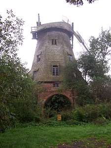 A Dutch windmill is situated in a colony, on the southern
side of the road to Pordenów, in the southern section of a homestead. The
bottom part is made of brick, while the tower and head are wooden and
covered by scale-shaped shingles. The building is in very poor
condition. A Dutch windmill is situated in a colony, on the southern
side of the road to Pordenów, in the southern section of a homestead. The
bottom part is made of brick, while the tower and head are wooden and
covered by scale-shaped shingles. The building is in very poor
condition.
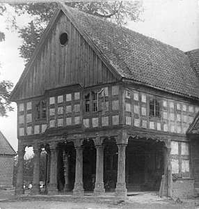 No. 27 was a house from the end of the 18th century.
It belonged to the Claassen family. The building had a log structure with
boarded quoins, a half-timbered arcade supported by 6 round posts and a
half-timbered wall, and a boarded upper section. The residential part had
2-bays with a slightly wider western bay, the large room in the
southwestern corner, a black kitchen in the large room bay, and a
bipartite, Z-shaped hallway. The gable elevation had 3 axes and the
frontal, 6 axes with an arcade located in the axes 2-4 from the north and
an entrance in the 3rd axis between two narrow windows. The house no
longer exists. No. 27 was a house from the end of the 18th century.
It belonged to the Claassen family. The building had a log structure with
boarded quoins, a half-timbered arcade supported by 6 round posts and a
half-timbered wall, and a boarded upper section. The residential part had
2-bays with a slightly wider western bay, the large room in the
southwestern corner, a black kitchen in the large room bay, and a
bipartite, Z-shaped hallway. The gable elevation had 3 axes and the
frontal, 6 axes with an arcade located in the axes 2-4 from the north and
an entrance in the 3rd axis between two narrow windows. The house no
longer exists.
Stankiewicz, s. 537Lipińska,t.3- 211, AG IV, BF, MP.
|
)