|
gm. Lichnowy Wielkie, pow. malborski, woj. pomorskie
Until 1945 Pordenau TK (Gotha, Endersch, Schrötter)
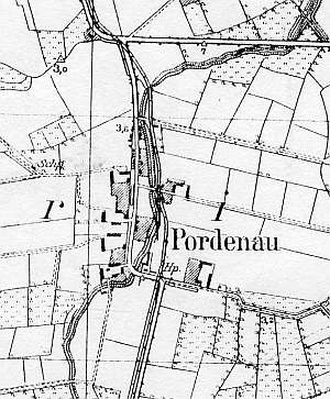
The village received privileges in 1399 or 1410. It was re-settled in the 17th century as a part of the village of Lichnowy Wielkie. The sources from 1776 mentioned the following Mennonite surnames: Ens, Esauł, Harder, Claassen, Sawatski, Wiens, and Woelcke. In 1820, the village had 208 residents, including 50 Mennonites, in 1869 - 20 houses and 245 residents, including 51 Mennonites, and in 1936 - 277 residents, including 36 Mennonites. In 1800, Mennonites erected a wooden House of Prayer used by residents of the nearby villages of Parczewo, Boręty, Dąbrowa, Listw, Lichnowy Wielkie, Lichnowy Małe, Parszewo, Nowa Cerkwia, and Gniazdowo. Village layout - a linear village in a north-south line along the Lichnowy Wielkie - Ostaszewo road with buildings on both sides of the road; large farms were located on its western side; detached colonial buildings and a Mennonite cemetery are located to the north of the village, on the eastern side of the road. The cultural landscape has partially survived with detectable homestead and field layouts. The Mennonite cemetery has been severely destroyed. A bethhaus was destroyed after 1945. Several wooden houses, a Kreutzhoff Dutch homestead, and an arcaded house have survived in the village and colonies. Roads are lined with old limes, oaks, ashes, and chestnut trees, which dominate in the village.
 No number - is a cross-shaped Dutch homestead situated in the
northern colony consisting of a wooden house and a contemporary cowshed
and a barn, which replicate the old layout. No number - is a cross-shaped Dutch homestead situated in the
northern colony consisting of a wooden house and a contemporary cowshed
and a barn, which replicate the old layout.
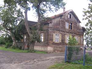
No. 22 is a building
from the 3rd or 4th quarter of the 19th century situated in the southern
section of the village, on the western side of a road, facing it with its
ridge. It is a single-storey building with a pointing sill. The house has
a log structure with covered quoins, vertically boarded half-timbered
pointing sill and gables, a wooden porch in the axes 2-4 from the north,
in front of an entrance in the 7-axial elevation.
 No. 25 is a
building from the 4th quarter of the 19th century situated on the northern
side of an eastbound local road, facing it with a ridge. Remains of
outbuildings are located in the northern section of the homestead. It is a
single-storey building with a pointing sill and a shallow projection with
a deep-seated porch (1st floor) in the middle of the southern elevation.
The house has a mixed structure: a corner-notched log structure with
protruding ends in the ground floor and a tenon-post/log (with log ends)
structure in the overhanging pointing sill and gables. The building is
richly decorated - windows, a porch, wind ties, and panel-frame doors and
shutters in the majority of the 10-field windows. No. 25 is a
building from the 4th quarter of the 19th century situated on the northern
side of an eastbound local road, facing it with a ridge. Remains of
outbuildings are located in the northern section of the homestead. It is a
single-storey building with a pointing sill and a shallow projection with
a deep-seated porch (1st floor) in the middle of the southern elevation.
The house has a mixed structure: a corner-notched log structure with
protruding ends in the ground floor and a tenon-post/log (with log ends)
structure in the overhanging pointing sill and gables. The building is
richly decorated - windows, a porch, wind ties, and panel-frame doors and
shutters in the majority of the 10-field windows.
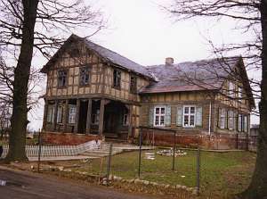 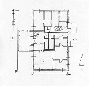 No. 36 is an
arcaded house situated in a colony (northern section of the village)
erected in 1811 and transformed in the 4th quarter of the 19th century. It
has a log structure with quoins covered by boards imitating pilaster, a
half-timbered pointing sill, an extension supported by 6 Tuscan columns
and half-timbered walls, gables and an extension filled with yellow brick,
a queen post - purlin roof structure with an angle brace, and square slate
and sheet metal roofing. The building has a 2-bay interior with a wider
western bay, the large room in the southwestern corner, a black kitchen
(largely) in the large room bay, two separate, rectangular hallways, which
separate the northern section. The interior has been modified. The gable
(southern) elevation has 4 axes and a 4-axial gable with two windows
enclosed by skylights, and a small semicircular window above. The western
elevation has 7 axes (symmetrical) with a centrally located entrance and a
2-axial extension (above the arcade) in the 3 central axes. Architectural
details as well as (partially) window and door frames have
survived. No. 36 is an
arcaded house situated in a colony (northern section of the village)
erected in 1811 and transformed in the 4th quarter of the 19th century. It
has a log structure with quoins covered by boards imitating pilaster, a
half-timbered pointing sill, an extension supported by 6 Tuscan columns
and half-timbered walls, gables and an extension filled with yellow brick,
a queen post - purlin roof structure with an angle brace, and square slate
and sheet metal roofing. The building has a 2-bay interior with a wider
western bay, the large room in the southwestern corner, a black kitchen
(largely) in the large room bay, two separate, rectangular hallways, which
separate the northern section. The interior has been modified. The gable
(southern) elevation has 4 axes and a 4-axial gable with two windows
enclosed by skylights, and a small semicircular window above. The western
elevation has 7 axes (symmetrical) with a centrally located entrance and a
2-axial extension (above the arcade) in the 3 central axes. Architectural
details as well as (partially) window and door frames have
survived.
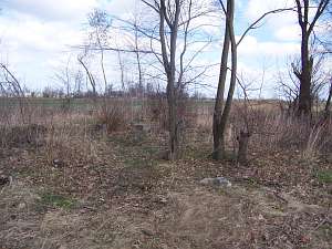 The Mennonite cemetery is located on the eastern side
of the road to Nowa Cerkwia, to the north of the village. It has been
severely devastated; the layout is undetectable, old trees have been cut
down, and gravestones, destroyed. There are no remains from the House of
Prayer, which stood there before 1945. The Mennonite cemetery is located on the eastern side
of the road to Nowa Cerkwia, to the north of the village. It has been
severely devastated; the layout is undetectable, old trees have been cut
down, and gravestones, destroyed. There are no remains from the House of
Prayer, which stood there before 1945.
SGKP, t. VIII, s. 815; ML t. III, s. 38-384; Lipinska, t. III, poz. 103; AG IV; BF; Warchoł.
|
)