|
gm. Markusy, pow. elbląski, woj. warmińsko - mazurskie
Until 1945 Cronsnest TK Kransnest (Gotha) Kronsnest (Endersch) Crohnest (Schrötter)
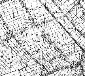
The village area was formed as a result of recession of a lake shore. Initially, the area was covered by a marsh and later by wet-ground forest, whose clearing began in 1558. Dutch colonists settled in the cleared area ca. 1590. . Rachowo was mentioned as a village in 1609. In 1820, the village had 292 residents, including 73 Mennonites. The sources from 1776 mentioned the following Mennonite surnames: Dircksen, Engbrecht, Froese, Fraetz, Kaettler, Kleewer, Kneihoff, Martens, Penner, Quiring, and Unger. The petition from 1868 was signed by Heinrich Engebrecht, Cornelius and Johann Froese, Heinrich and Jacob Harms, two Corneliuses Horn, Ditrich and Jacob Jantzen, Cornelius Martens, Jacob Pauls, Jacob and Joann Philipsen, Franz and two Peters Plenert, and Peter Penner. In 1885, the village had 45 włókas of land, 56 houses, and 355 residents, including 68 Mennonites. Village layout - a marsh row layout formed in the colonization period by two perpendicular causeways in a south-north, which are line cut across by a perpendicular causeway with a road from Kępniewo to Wiśniewo; by the flood bank, the layout changes into a characteristic flood bank linear village. The cultural landscape includes a detectable layout of draining ditches and polders, vegetation lining the draining canals, remains of trees lining roads, fragments of homestead vegetation, terpy, and several homesteads with the majority of outbuildings demolished or replaced. A foundation of a draining windmill (later a pumping station) has survived at the eastern end of the village.
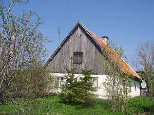
No. 1 is a house from a longitudinal Dutch homestead (the end
of the 18th century) situated in the northern section of the village, by
the Balewka flood bank, ca. 100 m to the east from the Rachowo - Markusy
road. It has a brick underpinning, a plastered log structure, a boarded
gable, a rafter - collar beam roof structure, and a thatched roof. The
layout of the building resembles a square with the large room in the
southeastern corner, a black kitchen between bays (shifted towards the
narrower bay), and a narrow, C-shaped hallway. The gable elevation has 2
axes.
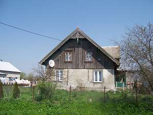
 No. 2 is a longitudinal Dutch homestead situated in the
northern section of the village, on the western side of the road, facing
it with its gable. The ridges of the residential and farming sections are
of the same height. A house has a plastered wooden structure with a
boarded gable, a small wooden extension (south side) supported by 2 posts
with a recently bricked-in arcade, a queen post - purlin roof structure,
and asbestos tile roofing. The interior has a wider southern bay with the
large room in the southeastern corner. The western section has been
transformed. The eastern elevation has 2 axes and a 3-axial gable with a
single window enclosed by quarter-circular skylights and a semicircular
skylight above. The southern elevation has 5 axes and an entrance in the
3rd axis with a shallow, small, currently bricked-in arcade. No. 2 is a longitudinal Dutch homestead situated in the
northern section of the village, on the western side of the road, facing
it with its gable. The ridges of the residential and farming sections are
of the same height. A house has a plastered wooden structure with a
boarded gable, a small wooden extension (south side) supported by 2 posts
with a recently bricked-in arcade, a queen post - purlin roof structure,
and asbestos tile roofing. The interior has a wider southern bay with the
large room in the southeastern corner. The western section has been
transformed. The eastern elevation has 2 axes and a 3-axial gable with a
single window enclosed by quarter-circular skylights and a semicircular
skylight above. The southern elevation has 5 axes and an entrance in the
3rd axis with a shallow, small, currently bricked-in arcade.
 No. 22 is a house from a longitudinal Dutch homestead
situated in the southern section of the village, on the eastern side of a
road, facing it with its gable. It was erected in the 1st or 2nd quarter
of the 19th century on a brick underpinning. It has a plastered log
structure, a vertically boarded roof structure, a rafter - collar beam
roof structure, and pantile roofing. The interior had a 2-bay layout with
similar bays, a centrally located black kitchen and the large room in the
southwestern corner. The gable elevation has 2 axes with a single window
in the gable. The southern elevation has been transformed - 3
axes. No. 22 is a house from a longitudinal Dutch homestead
situated in the southern section of the village, on the eastern side of a
road, facing it with its gable. It was erected in the 1st or 2nd quarter
of the 19th century on a brick underpinning. It has a plastered log
structure, a vertically boarded roof structure, a rafter - collar beam
roof structure, and pantile roofing. The interior had a 2-bay layout with
similar bays, a centrally located black kitchen and the large room in the
southwestern corner. The gable elevation has 2 axes with a single window
in the gable. The southern elevation has been transformed - 3
axes.
 No. 24 is a wooden house with a log structure, a rich
decoration in gables, and a wooden porch. The building was erected in
place of an earlier house. It was constructed in two stages - its initial
form was completed at the beginning of the 19th century and then at the
end of the 19th century or at the beginning of the 20th century,
carpenters added a pointing sill, an attic room, fretwork decoration, and
a wooden porch. The adjacent outbuildings (replaced in the 1980s -
traditional location) formed a longitudinal homestead. . The house was
erected in the characteristic regional style, which is easily detectable
in the interior layout. It has a fretwork decoration with cobweb and plant
motifs typical for the end of the 19th century style. Original doors with
ratchet locks and wrought iron hinges have survived. Plates of the ratchet
locks are decorated with motifs typical for the beginning of the 19th
century. The building has been modified. No. 24 is a wooden house with a log structure, a rich
decoration in gables, and a wooden porch. The building was erected in
place of an earlier house. It was constructed in two stages - its initial
form was completed at the beginning of the 19th century and then at the
end of the 19th century or at the beginning of the 20th century,
carpenters added a pointing sill, an attic room, fretwork decoration, and
a wooden porch. The adjacent outbuildings (replaced in the 1980s -
traditional location) formed a longitudinal homestead. . The house was
erected in the characteristic regional style, which is easily detectable
in the interior layout. It has a fretwork decoration with cobweb and plant
motifs typical for the end of the 19th century style. Original doors with
ratchet locks and wrought iron hinges have survived. Plates of the ratchet
locks are decorated with motifs typical for the beginning of the 19th
century. The building has been modified.
 The cemetery is situated
on the northern side of the Wiśniewo - Kępniewo road. It has a square
layout. Its area has been severely devastated; basically, there are no old
trees. Fragments of concrete tombs and several plate supports in the form
of tree trunks have survived. The cemetery is situated
on the northern side of the Wiśniewo - Kępniewo road. It has a square
layout. Its area has been severely devastated; basically, there are no old
trees. Fragments of concrete tombs and several plate supports in the form
of tree trunks have survived.
SGKP, t. IV, s. 695; Lipińska, s. 122 AG, BF, MP
|
)