|
gm. Gronowo Elbląskie, pow. elbląski, woj. warmińsko - mazurskie
Preussische Rosengarth TK (Schrőtter) Rosengart (Gotha), Preussische Rosengart (Endersch)
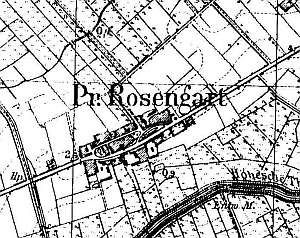
The village was established in 1355 by the Dzierzgoń commander, Konrad Braunschweig, who also founded the St. Catherine church. This Medieval building from the 14th century was taken down between 1655 and 1660. Dutch colonists settled in the village in the 2nd half of the 16th century. The sources from 1776 mention the following surnames: Dau, Dick, Friesen, Froes, Goertz, Goertzen, Kaettler, Claassen, Kleewer, Cornelsen, Martens, Meckelburger, Nickel, Niessen, Puls, Penner, Peters, Philipsen, and Wieb. In 1789, the village had 126 Mennonites. In 1820, there were 221 residents, including 83 Mennonites. The petition from 1868 was signed by Peter Claassen, Wilhelm, Cornelius and Jacob Froese, Heinrich Harms, Herman Puls, Cornelius, Franz, Joann Wiehler, and Abraham Froese. As a result of the reconciliation of feuding groups of Frisian Mennonites and the fact that the 1890 flood destroyed the church in Markusy, members of the community began the construction of a church in Rozgart, which was to be a branch of the Mennonite church in Jezioro. In 1936, the village had 54 Mennonites. Village layout - an oval (linear - square) village with 3 large farms in the southern section and 2 small farms in the western and southeastern sections. The cultural landscape is relatively well preserved with a detectable village layout, partially preserved historical buildings, including two arcaded houses, wooden buildings from the 19th century, masonry buildings from the end of the 19th and beginning of the 20th centuries, and scarce Dutch homesteads with some modern buildings. The village also has a Mennonite cemetery (Lutheran and Mennonite?) located in the central section, an old Mennonite church with a belfry, a cobble stone road lined lime trees, a detectable field layout in the southern and northern sections, and buildings of a pumping station from the 20th century located by the flood bank.
No. 28 is a longitudinal Dutch homestead situated in the
northeastern section of the village, on the eastern side of a road, facing
it with its ridge. The homestead has a fire wall, which separates a
cowshed (a barn has been demolished) from a house. The house has a
plastered wooden structure, a boarded gable, a queen post - purlin roof
structure with angle braces, and pantile roofing. The interior has been
modified and has a 2-bay layout. The southern elevation has 2 axes and a
4-axial gable (lower section) with two windows enclosed by rectangular
skylights and a small window above. The western elevation has 5 axes and
an entrance in the 2nd axis from the south.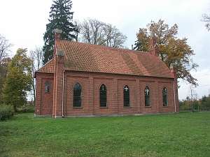 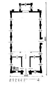 The Mennonite church
(currently, the Catholic St. Peter and Paul branch church) is situated in
the village center, on the southern side of a road, on a rectangular plot.
It was erected in 1890. Between 1945 and 1957, it was used as a warehouse.
It is a brick building with a rectangular layout, a small rectangular
chancel, an open interior, a broken "English" ceiling with a wooden
gallery in the northern section, and a brick elevation enclosed by lesene
strips and topped by a block cornice. The side elevations have 5 axes with
pointed-arch windows and an offset portal with a pointed-arch entrance in
the western elevation. The main entrance is located in a similar portal in
the northern elevation. The church has a rectangular pinnacle in an axis
in a gable with a pseudo-bell topped by a high broach roof. There is a
neo-Gothic, brick belfry (an unusual structure in the Mennonite
architecture) erected at the same time as the church. It is located in the
northwestern section of the plot. The Mennonite church
(currently, the Catholic St. Peter and Paul branch church) is situated in
the village center, on the southern side of a road, on a rectangular plot.
It was erected in 1890. Between 1945 and 1957, it was used as a warehouse.
It is a brick building with a rectangular layout, a small rectangular
chancel, an open interior, a broken "English" ceiling with a wooden
gallery in the northern section, and a brick elevation enclosed by lesene
strips and topped by a block cornice. The side elevations have 5 axes with
pointed-arch windows and an offset portal with a pointed-arch entrance in
the western elevation. The main entrance is located in a similar portal in
the northern elevation. The church has a rectangular pinnacle in an axis
in a gable with a pseudo-bell topped by a high broach roof. There is a
neo-Gothic, brick belfry (an unusual structure in the Mennonite
architecture) erected at the same time as the church. It is located in the
northwestern section of the plot.
The Lutheran/Mennonite
cemetery is located in the village center, on the western side of the
church. It was established on a rectangular plot. It is lined with trees
and has 3 intersecting lime alleys. It has been severely devastated -
destroyed gate. There are several gravestones in the form of stalls, tree
trunks, as well as marblite and concrete tombs with the surnames Fröse,
Catharina Wiehler, and Anna Harms (stalls).
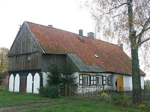 No. 12/13 is an
arcade house with a gable arcade situated in the village center, on the
southern side of a road, facing it with its gable. It was erected at the
end of the 18th century and modified in the 19th century. The building has
a plastered log structure with a half-timbered extension supported by 6
posts and a bricked-in arcade. It has a rafter - two-collar beam roof
structure and a common roof (pantile roofing) above the extension and the
house. No. 12/13 is an
arcade house with a gable arcade situated in the village center, on the
southern side of a road, facing it with its gable. It was erected at the
end of the 18th century and modified in the 19th century. The building has
a plastered log structure with a half-timbered extension supported by 6
posts and a bricked-in arcade. It has a rafter - two-collar beam roof
structure and a common roof (pantile roofing) above the extension and the
house.
ML t. III, s. 540;, Lipińska, t.III, poz. 92; AG, MP, BF Warchoł,
|
)