|
gm. Stegna, pow. nowodworski, woj. pomorskie
Until 1945 Fischerbabke (Endersch, Schrötter)
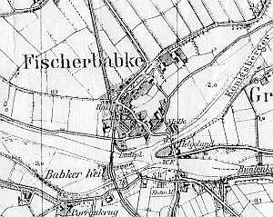
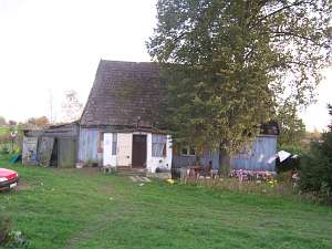
The village was founded in 1600 by Dutch colonists. Village layout - a multi-street village, a colonial village, and a flood bank village on terpy. The cultural landscape has survived in fragments; a spatial layout and original layout of homesteads are not detectable. In the 1980s, 10 homesteads still had historical buildings. Currently, there are ca. 8 remains of old Dutch homesteads in different degrees of transformation - most frequently, with replaced outbuildings. There are 4 wooden houses from the 19th century and masonry buildings from the end of the 19th century and the beginning of the 20th century. A masonry house (poor condition) from the 2nd half of the 18th century and an arcaded house in a homestead by the road to Sztutowo have survived. There are three functioning steel draw bridges - two with roads and one with railroad tracks. Contemporary buildings are prevailing.
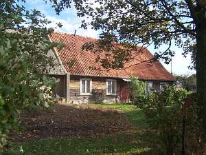 A Dutch homestead of the longitudinal type is situated in the
western section of the village, on the northern side of the road, facing
it with its ridge. A cowshed (new) is separated from a house by a fire
wall. The house dates from the mid 19th century. It has a corner-notched
log structure with boarded quoins a vertically boarded gable, and pantile
roofing. The gable elevation has 3 axes and a two-level gable (4 axes in
the lower section) with two windows enclosed by rectangular skylights
topped by segmented arches and a doubled form of the skylight above. The
southern elevation has 5 axes and a centrally located
entrance. A Dutch homestead of the longitudinal type is situated in the
western section of the village, on the northern side of the road, facing
it with its ridge. A cowshed (new) is separated from a house by a fire
wall. The house dates from the mid 19th century. It has a corner-notched
log structure with boarded quoins a vertically boarded gable, and pantile
roofing. The gable elevation has 3 axes and a two-level gable (4 axes in
the lower section) with two windows enclosed by rectangular skylights
topped by segmented arches and a doubled form of the skylight above. The
southern elevation has 5 axes and a centrally located
entrance.
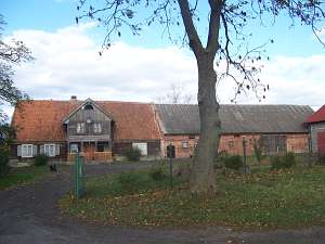
 No. 16 is a house from a Dutch homestead of the angular
type situated by an intersection of local roads, on the western side of
the road to Stegny, facing it with its ridge. Farming buildings are
contemporary and are separated from a house by a high fire wall. The house
dates from the mid 19th century and has a stone foundation, a vertically
boarded log structure, half-timbered extension in the eastern roof slope,
and pantile roofing. The interior has a 2-bay layout with the large room
in the southeastern corner, a black kitchen in the large room bay, and an
L-shaped hallway separating rooms by the northern wall. The gable
elevation has 3 axes and a 4-axial gable with two windows enclosed by
rectangular skylight and a semicircular skylight above. The eastern
elevation has 6 axes and an entrance in the 3rd axis from the
north. No. 16 is a house from a Dutch homestead of the angular
type situated by an intersection of local roads, on the western side of
the road to Stegny, facing it with its ridge. Farming buildings are
contemporary and are separated from a house by a high fire wall. The house
dates from the mid 19th century and has a stone foundation, a vertically
boarded log structure, half-timbered extension in the eastern roof slope,
and pantile roofing. The interior has a 2-bay layout with the large room
in the southeastern corner, a black kitchen in the large room bay, and an
L-shaped hallway separating rooms by the northern wall. The gable
elevation has 3 axes and a 4-axial gable with two windows enclosed by
rectangular skylight and a semicircular skylight above. The eastern
elevation has 6 axes and an entrance in the 3rd axis from the
north.
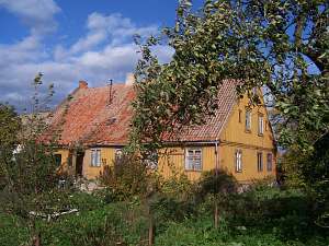
 No. 65 is a longitudinal Dutch homestead situated in the
eastern section of the village, on the northern side of the road to
Sztutowo, facing it with its ridge. Farming buildings are separated from a
house by a fire wall. The house was erected in the 1st quarter of the 19th
century; an arcade was added later. Until 1945, the house was owned by
Walter Essau. It has a log structure with quoins covered by boards
imitating rustication, a log extension supported by 4 Tuscan columns, a
vertically boarded gable, and pantile roofing. The building has a
rectangular, 2-bay layout with slightly wider southern bay with the large
room in the southwestern corner, a central black kitchen, and an L-shaped,
bipartite hallway. The arcade hallway (divided later) has stairs leading
to the attic, while the wide utility hallway has 4 doors in the eastern
wall. A shallow arcade is located on the southern side. The gable
elevation has 3 axes and a 3-axial gable. The southern elevation has 6
axes, an entrance in the 3rd axis from the east, and a centrally located
arcade, which is shifted in relation to the window in the 2nd eastern
axis. No. 65 is a longitudinal Dutch homestead situated in the
eastern section of the village, on the northern side of the road to
Sztutowo, facing it with its ridge. Farming buildings are separated from a
house by a fire wall. The house was erected in the 1st quarter of the 19th
century; an arcade was added later. Until 1945, the house was owned by
Walter Essau. It has a log structure with quoins covered by boards
imitating rustication, a log extension supported by 4 Tuscan columns, a
vertically boarded gable, and pantile roofing. The building has a
rectangular, 2-bay layout with slightly wider southern bay with the large
room in the southwestern corner, a central black kitchen, and an L-shaped,
bipartite hallway. The arcade hallway (divided later) has stairs leading
to the attic, while the wide utility hallway has 4 doors in the eastern
wall. A shallow arcade is located on the southern side. The gable
elevation has 3 axes and a 3-axial gable. The southern elevation has 6
axes, an entrance in the 3rd axis from the east, and a centrally located
arcade, which is shifted in relation to the window in the 2nd eastern
axis.
 A house from a Dutch homestead (probably of the angular
type) is situated in the eastern section of the village, by the Szkarpowa
flood bank, facing it with its ridge. Farming buildings have been taken
down. The house dates from the mid 19th century and has a vertically
boarded wooden structure and interlocking tile roofing. The gable
elevation has 2 axes and a 2-level gable with 3 axes in the lower section,
two windows and a narrow skylight on the south side and a single window
above. The northern elevation has 5 axes with an entrance in the 2nd
axis from the east. A house from a Dutch homestead (probably of the angular
type) is situated in the eastern section of the village, by the Szkarpowa
flood bank, facing it with its ridge. Farming buildings have been taken
down. The house dates from the mid 19th century and has a vertically
boarded wooden structure and interlocking tile roofing. The gable
elevation has 2 axes and a 2-level gable with 3 axes in the lower section,
two windows and a narrow skylight on the south side and a single window
above. The northern elevation has 5 axes with an entrance in the 2nd
axis from the east.
Lipińska, t. III, poz.249.
|
)