|
gm. Nowy Dwór Gdański, pow. nowodworski, woj. pomorskie
Until 1945 Walldorf , Neustädterwald, Pletzendorf, Peterhagenfeld TK (Endersch, Schrötter)
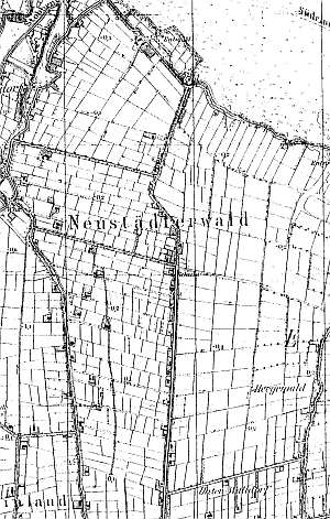
The village of Starocin was formed at the end of the 20th century from the colony of Gozdawa, western farms of Powalina, and partially eastern farms of Piotrowo. Village layout - single-homestead village on terpy on both sides of a road running northbound from the Marzęcino - Nowy Dwór Gdański road and on the northern side of that road. The cultural landscape includes: a detectable layout of terpy, draining canals, fields. There are ca. 12 - 14 Dutch homesteads with ca. 8 wooden, partially bricked buildings. The buildings of some homesteads have been replaced preserving the traditional layout. A small park has survived in the homestead no. 44.
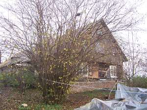
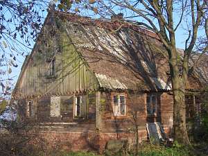 A house from a Dutch homestead (farming buildings have been
partially taken down) is situated in the northern section of the village,
on the eastern side of a local road, facing it with its ridge. It was
erected in the mid 19th century on a brick foundation and has a log
structure with quoins covered by boards imitating Tuscan pilaster, a
vertically boarded gable, a rafter - collar beam roof structure, a
thatched roof patched with sheet metal, and a bullseye in the southern
roof slope. The western elevation has 3 axes and a 1-axial gable. The
eastern elevation has 3 axes and an entrance with a porch in the ... axis
from the north. A house from a Dutch homestead (farming buildings have been
partially taken down) is situated in the northern section of the village,
on the eastern side of a local road, facing it with its ridge. It was
erected in the mid 19th century on a brick foundation and has a log
structure with quoins covered by boards imitating Tuscan pilaster, a
vertically boarded gable, a rafter - collar beam roof structure, a
thatched roof patched with sheet metal, and a bullseye in the southern
roof slope. The western elevation has 3 axes and a 1-axial gable. The
eastern elevation has 3 axes and an entrance with a porch in the ... axis
from the north.
 No. 18 is a house from a Dutch homestead (farming
buildings have been modified) situated in the western section of the
village, on the northern side of the Marzęcino - Nowy Dwór Gdański road,
facing it with its ridge. It was erected in the 2nd half of the 19th
century on a brick foundation and has a log structure with quoins covered
by boards imitating Tuscan pilaster, a vertically boarded gable, a queen
post - purlin roof structure, and sheet metal roofing. The interior and
elevations have been modified. The southern elevation currently has 2 axes
and a single-axial gable. The western elevation has 3 axes. No. 18 is a house from a Dutch homestead (farming
buildings have been modified) situated in the western section of the
village, on the northern side of the Marzęcino - Nowy Dwór Gdański road,
facing it with its ridge. It was erected in the 2nd half of the 19th
century on a brick foundation and has a log structure with quoins covered
by boards imitating Tuscan pilaster, a vertically boarded gable, a queen
post - purlin roof structure, and sheet metal roofing. The interior and
elevations have been modified. The southern elevation currently has 2 axes
and a single-axial gable. The western elevation has 3 axes.
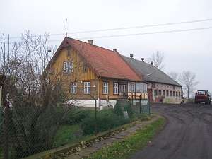
 No.
44 is a Dutch homestead of a (originally) angular and later longitudinal
layout situated in a colony in the southwestern section of the village in
an east-west axis with a house on the western side. A cowshed from the
1930s is separated from the house by a fire wall. A barn after a
modification has been separated from the house. The house was erected in
the 3rd quarter of the 19th century on a high, brick foundation. It is a
single-storey building with a pointing sill, a boarded log structure, a
vertically boarded gable and the pointing sill (horizontally boarded at
the window level), quoins covered by decoratively carved boards, a queen
post - purlin roof structure with an angle brace, and asbestos tile
roofing. The gable elevation has 4 axes and a 4-axial gable with two
windows enclosed by rectangular skylights topped by segmented arches and a
doubled form of the skylight above. The northern elevation has 6 axes with
a modern porch in the 3 eastern axes. The pointing sill has 3 windows
which are shifted in relation to the windows below. No.
44 is a Dutch homestead of a (originally) angular and later longitudinal
layout situated in a colony in the southwestern section of the village in
an east-west axis with a house on the western side. A cowshed from the
1930s is separated from the house by a fire wall. A barn after a
modification has been separated from the house. The house was erected in
the 3rd quarter of the 19th century on a high, brick foundation. It is a
single-storey building with a pointing sill, a boarded log structure, a
vertically boarded gable and the pointing sill (horizontally boarded at
the window level), quoins covered by decoratively carved boards, a queen
post - purlin roof structure with an angle brace, and asbestos tile
roofing. The gable elevation has 4 axes and a 4-axial gable with two
windows enclosed by rectangular skylights topped by segmented arches and a
doubled form of the skylight above. The northern elevation has 6 axes with
a modern porch in the 3 eastern axes. The pointing sill has 3 windows
which are shifted in relation to the windows below.
 No. 43 is a
house from a Dutch homestead (farm building have been partially
demolished) situated in a colony, in the southwestern section of the
village, on the eastern side of a local road, in an east-west axis with a
house on the western side. The building dates from the mid 19th century
and has a brick foundation, a partially plastered log structure, a
vertically boarded gable, a rafter - collar beam roof structure, and
pantile roofing. The western elevation has 3 axes and a 4-axial gable with
two windows enclosed by rectangular skylights, and a rectangular skylight
above. The southern elevation has 4 axes and an entrance on the east
side. No. 43 is a
house from a Dutch homestead (farm building have been partially
demolished) situated in a colony, in the southwestern section of the
village, on the eastern side of a local road, in an east-west axis with a
house on the western side. The building dates from the mid 19th century
and has a brick foundation, a partially plastered log structure, a
vertically boarded gable, a rafter - collar beam roof structure, and
pantile roofing. The western elevation has 3 axes and a 4-axial gable with
two windows enclosed by rectangular skylights, and a rectangular skylight
above. The southern elevation has 4 axes and an entrance on the east
side.
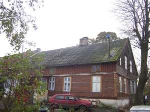
 No. 38 is a longitudinal Dutch homestead located in a
colony in the southern section of the village, in a north-shout axis with
a house on the south side. Farming buildings are higher and have been
re-bricked with preserved interior. The house dates from the 2nd-3rd
quarters of the 19th century and has a log structure with quoins covered
by boards cut into the Parthian arch, a vertically boarded pointing sill
and a gable, a queen post - purlin roof structure, and asbestos tile
roofing. The gable elevation has been modified and currently has 2 axes
and 3-axial gable with a wide window enclosed by narrow skylights and a
semicircular skylight above. The eastern elevation has 5 axes with an
entrance in the 2nd axis from the north. No. 38 is a longitudinal Dutch homestead located in a
colony in the southern section of the village, in a north-shout axis with
a house on the south side. Farming buildings are higher and have been
re-bricked with preserved interior. The house dates from the 2nd-3rd
quarters of the 19th century and has a log structure with quoins covered
by boards cut into the Parthian arch, a vertically boarded pointing sill
and a gable, a queen post - purlin roof structure, and asbestos tile
roofing. The gable elevation has been modified and currently has 2 axes
and 3-axial gable with a wide window enclosed by narrow skylights and a
semicircular skylight above. The eastern elevation has 5 axes with an
entrance in the 2nd axis from the north.
SGKP, t. XI, s. 241; Schmid, s.1-7, Stankiewicz, s. 539, Lipińska, t. III, poz. 228.
|
)