|
gm. Stegna, pow. nowodworski, woj. pomorskie
Until 1945 Stobbendorf (Endersch, Schrötter)
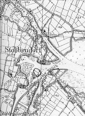
The village is located in the area of a former Nowy Dwór estate. It was leased to Dutch colonists in 1594 (or 1629). The village had 15 włókas and 24 morgas of land, but this area was reduced to 12 włókas and 1 morga as a result of a flood. In 1789, the village had 58 Mennonites; the following surnames were mentioned Ens, Friessen, Doose, Krahn, Lemcke, Nickel, Peters, Quapp, Quiring, Simons, Stenfeder, and Wieb. In 1820, the village had 452 residents, including 84 Mennonites. There were 18 Mennonites in 1930s. Village layout - a flood bank linear village located by the Stara Tuga flood bank and a marsh row village; until 1945, the village had an inn and a draining windmill (the southern section of the village), which was replaced by pumping stations. The cultural landscape includes: a detectable layout of terpy, draining canals, polders, 12 Dutch homesteads, including 3 angular homesteads, and ca. 14 wooden buildings.
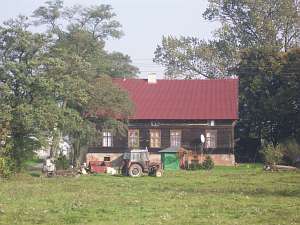 There is a house located in the eastern section of the
village, on the northern side of the local road, facing it with its ridge
(ca. 100 m from the road). The building dates from the 1880s. It has a log
structure with quoins covered by boards, a low pointing sill, a queen post
- purlin roof structure, vertically boarded gables, and sheet metal
roofing. The gable elevation has 4 axes and a two-level gable (4 axes in
the lower level) with two windows enclosed by narrow skylights and a
single window above. The southern elevation has 5 axes. There is a house located in the eastern section of the
village, on the northern side of the local road, facing it with its ridge
(ca. 100 m from the road). The building dates from the 1880s. It has a log
structure with quoins covered by boards, a low pointing sill, a queen post
- purlin roof structure, vertically boarded gables, and sheet metal
roofing. The gable elevation has 4 axes and a two-level gable (4 axes in
the lower level) with two windows enclosed by narrow skylights and a
single window above. The southern elevation has 5 axes.
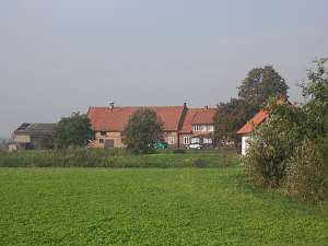 A
building without a number is a longitudinal Dutch homestead from 1930s
situated on a terpa, on the southern side of a road, facing it with its
gable (the cowshed is separated from the rest by a high fire wall; a barn
has been demolished). A
building without a number is a longitudinal Dutch homestead from 1930s
situated on a terpa, on the southern side of a road, facing it with its
gable (the cowshed is separated from the rest by a high fire wall; a barn
has been demolished).
 A building without a number is a Dutch
homestead of the longitudinal type situated on a terpa on the southern
side of the road, facing it with its ridge. The barn is separated from the
rest by a fire wall of the same height. A barn has been demolished. The
house dates from the 3rd quarter of the 19th century. It is a wooden,
single-storey building with a low pointing sill. The building has a
vertically boarded log structure, vertically boarded (with binding) gable,
a wooden porch in front of an entrance (western side), a queen post -
purlin roof structure, and asbestos tile roofing. A detached barn is
located in the eastern section of the yard. A building without a number is a Dutch
homestead of the longitudinal type situated on a terpa on the southern
side of the road, facing it with its ridge. The barn is separated from the
rest by a fire wall of the same height. A barn has been demolished. The
house dates from the 3rd quarter of the 19th century. It is a wooden,
single-storey building with a low pointing sill. The building has a
vertically boarded log structure, vertically boarded (with binding) gable,
a wooden porch in front of an entrance (western side), a queen post -
purlin roof structure, and asbestos tile roofing. A detached barn is
located in the eastern section of the yard.
 No. 29 is a Dutch
homestead of the longitudinal type situated on a terpa in the eastern
section of the village, on the southern side of the road, facing it with
its ridge. A cowshed (plastered) is separated from the rest by a fire
wall. The homestead has a modern, masonry barn. The house dates from the
4th quarter of the 19th century (it is made of brick or is
bricked-in). No. 29 is a Dutch
homestead of the longitudinal type situated on a terpa in the eastern
section of the village, on the southern side of the road, facing it with
its ridge. A cowshed (plastered) is separated from the rest by a fire
wall. The homestead has a modern, masonry barn. The house dates from the
4th quarter of the 19th century (it is made of brick or is
bricked-in).
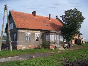
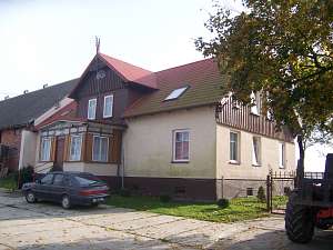 No. 21 is a house from a Dutch homestead probably of
the angular type situated in the eastern section of the village, on the
southern side of the road, facing it with its gable. Farming buildings
have been replaced. It is a single-storey building dating from 1861. It
has a low pointing sill, a wooden, bricked structure, a vertically boarded
gable, a wooden porch in front of an entrance (western side), a queen post
- purlin roof structure with angle braces, and modern pantile roofing. The
gable elevation has 3 axes and a 4-axial gable with two windows enclosed
by smaller windows topped by segmented arches and a doubled form of the
small side windows above. The western elevation has been rebuilt and has 4
axes and an entrance with a wooden porch richly decorated with fretwork.
There is a park located to the south of the house. No. 21 is a house from a Dutch homestead probably of
the angular type situated in the eastern section of the village, on the
southern side of the road, facing it with its gable. Farming buildings
have been replaced. It is a single-storey building dating from 1861. It
has a low pointing sill, a wooden, bricked structure, a vertically boarded
gable, a wooden porch in front of an entrance (western side), a queen post
- purlin roof structure with angle braces, and modern pantile roofing. The
gable elevation has 3 axes and a 4-axial gable with two windows enclosed
by smaller windows topped by segmented arches and a doubled form of the
small side windows above. The western elevation has been rebuilt and has 4
axes and an entrance with a wooden porch richly decorated with fretwork.
There is a park located to the south of the house.
 No. 29 is a house from an angular
Dutch homestead situated on a terpa, on the eastern side of the Tuga flood
bank, facing the bank with its gable. A cowshed is separated from the rest
by a high fire wall. The cowshed and barn are modern. The house dates from
the 4th quarter of the 19th century (it was renovated in 1919). Until
1945, it belonged to the Klaassen family. It is a single-storey building
with a log structure, which is vertically boarded at the lower level and
horizontally boarded above. The building has a low pointing sill, a
vertically boarded gable, a wooden porch in front of an entrance (southern
side), a queen post - purlin roof structure with angle braces, and
asbestos tile roofing. The gable elevation has 2 axes, a 4-axial gable,
two windows enclosed by smaller windows bound by segmented arches, and a
semicircular window above. The southern elevation has been modified and
has 4 axes and an entrance with a wooden porch in the 3rd axis from the
west. A wooden coach house is located in the southwestern section of the
yard. No. 29 is a house from an angular
Dutch homestead situated on a terpa, on the eastern side of the Tuga flood
bank, facing the bank with its gable. A cowshed is separated from the rest
by a high fire wall. The cowshed and barn are modern. The house dates from
the 4th quarter of the 19th century (it was renovated in 1919). Until
1945, it belonged to the Klaassen family. It is a single-storey building
with a log structure, which is vertically boarded at the lower level and
horizontally boarded above. The building has a low pointing sill, a
vertically boarded gable, a wooden porch in front of an entrance (southern
side), a queen post - purlin roof structure with angle braces, and
asbestos tile roofing. The gable elevation has 2 axes, a 4-axial gable,
two windows enclosed by smaller windows bound by segmented arches, and a
semicircular window above. The southern elevation has been modified and
has 4 axes and an entrance with a wooden porch in the 3rd axis from the
west. A wooden coach house is located in the southwestern section of the
yard.
ML, t.IV, s.254, Lipińska, t. III, poz.254; AG IV.
|
)