|
gm. Malbork, pow. malborski, woj. pomorskie
Until 1945 Heubuden ( Endersch, Schrötter) ( not marked in Goth), Hejbudy,
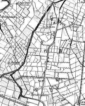
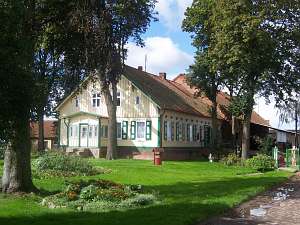
In the Teutonic Knights period, the area was used a pastures for knights' horses. The sources from the 15th century mentioned the name Howbude related to wooden buildings (sheds). The name Heybudi was mentioned in 1510. The village was founded in 1562 and then in 1565, leased to Dutch settlers. Flemish congregation in Stogi was the largest rural Mennonite community in the Żuławy region; however, until 1728, it was under the authority of the Gdańsk community Wielkie Żuławy. In 1728, the community became independent, and Stogi elders conducted services in Lichnowy Wielkie, Laskowice Wielkie, Pogorzała Wieś, Malbork, Czatków, and Jarczewo. In 1768, the Mennonites erected a wooden house of prayer. The sources mention the following Mennonite surnames: von Bergen, Born, Bickert, Konrad, Dickmann, Dicksen, Dircksen, Dick, Ens, Epp, Fast, Friesen, Giesbrecht, Gunter, Hamm, Harder, Claasen, Kosdorff, and Loewen. In 1820, the village had 301 residents, including 202 Mennonites. In the 2nd half of the 19th century, the village had 137 włókas of land, 45 houses, 154 Catholics and Lutherans, and 176 Mennonites. The village was an active center of the Flemish Mennonite community - Stogi - Malbork, which in the prewar period was the largest rural congregation with 1092 members and 358 children below 15 in 1929. Village layout - a single-homestead, irregular, partially linear village with buildings on the western side of the road running northward from the Malbork - Tczew highway. The cultural landscape has partially survived. Historical wooden buildings (dating from the 19th century) are scarce and their number is decreasing. Farming buildings have been taken down or replaced by modern buildings in almost all old Dutch homesteads. A field layout, a system of draining canals, and vegetation surrounding homesteads have survived.
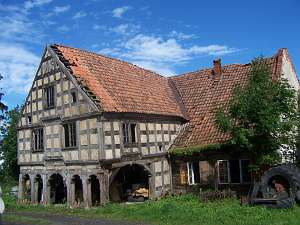
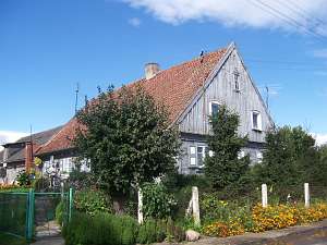
 No. 9 is a house from an old Dutch homestead of the angular
type erected in 1798 for Johann Epp. It is situated in the northern
section of the village, on the eastern side of the road. Farming
buildings, which were separated from the house by a high fire wall, were
demolished. The house has a brick underpinning, a log structure with
quoins covered by boards imitating pilaster, a vertically boarded gable,
an arcade (south side) supported by 6 pillars and half-timbered walls, a
queen post - purling roof structure covered by pantiles. The interior has
a 2-bay layout with a wide southern bay, the large room in the
southwestern corner, a black kitchen in the large room bay, and an
inverted Z-shaped bipartite hallway, which separates the other section of
the house - two rooms on each side of a corridor leading to a cowshed. The
western gable elevation has 3 axes, a two-level gable with 3 axes at the
lower level, and a single window above. The southern elevation has 7 axes
with a 2-window extension and an arcade in the 3 central axes and a
centrally located entrance. The house has rich architectural detail (e.g.
decorative entrance door). The building is in a very poor
condition. No. 9 is a house from an old Dutch homestead of the angular
type erected in 1798 for Johann Epp. It is situated in the northern
section of the village, on the eastern side of the road. Farming
buildings, which were separated from the house by a high fire wall, were
demolished. The house has a brick underpinning, a log structure with
quoins covered by boards imitating pilaster, a vertically boarded gable,
an arcade (south side) supported by 6 pillars and half-timbered walls, a
queen post - purling roof structure covered by pantiles. The interior has
a 2-bay layout with a wide southern bay, the large room in the
southwestern corner, a black kitchen in the large room bay, and an
inverted Z-shaped bipartite hallway, which separates the other section of
the house - two rooms on each side of a corridor leading to a cowshed. The
western gable elevation has 3 axes, a two-level gable with 3 axes at the
lower level, and a single window above. The southern elevation has 7 axes
with a 2-window extension and an arcade in the 3 central axes and a
centrally located entrance. The house has rich architectural detail (e.g.
decorative entrance door). The building is in a very poor
condition.
A detached, wooden granary/coach house has also
survived.
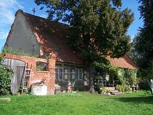 No. 14 is a house from a Dutch homestead of the angular
type (farming section has been demolished) situated in the southern
section of the village, on the western side of the road, facing it with
its gable. There is a small park (east side) established in 1847. Until
1945, the homestead belonged to Willi Jansen. The house has a brick
foundation, a log structure with covered quoins, a vertically boarded
gable, a high ceramic roof, and an original interior layout with the large
room in the southeastern corner and a black kitchen in the large room bay.
The eastern gable elevation has 3 axes, a two-level gable with 2 axes at
the lower level, and a single window above. The southern elevation has 7
axes with a centrally located entrance. No. 14 is a house from a Dutch homestead of the angular
type (farming section has been demolished) situated in the southern
section of the village, on the western side of the road, facing it with
its gable. There is a small park (east side) established in 1847. Until
1945, the homestead belonged to Willi Jansen. The house has a brick
foundation, a log structure with covered quoins, a vertically boarded
gable, a high ceramic roof, and an original interior layout with the large
room in the southeastern corner and a black kitchen in the large room bay.
The eastern gable elevation has 3 axes, a two-level gable with 2 axes at
the lower level, and a single window above. The southern elevation has 7
axes with a centrally located entrance.
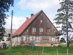
 No. 26 is a house from
the mid 1800s, which used to be a part of a Dutch homestead of the angular
type (farming section has been demolished) situated in the central section
of the village, on the western side of the road, facing it with its gable.
The house has a brick foundation, a log structure with covered quoins, a
vertically boarded gable, a high ceramic roof, and an original interior
layout with the large room in the southeastern corner and a black kitchen
in the large room bay. The eastern gable elevation has 3 axes, a two-level
gable with 2 axes at the lower level, and a single window above. The
southern elevation has 6 axes with an entrance located in the 3rd
axis. No. 26 is a house from
the mid 1800s, which used to be a part of a Dutch homestead of the angular
type (farming section has been demolished) situated in the central section
of the village, on the western side of the road, facing it with its gable.
The house has a brick foundation, a log structure with covered quoins, a
vertically boarded gable, a high ceramic roof, and an original interior
layout with the large room in the southeastern corner and a black kitchen
in the large room bay. The eastern gable elevation has 3 axes, a two-level
gable with 2 axes at the lower level, and a single window above. The
southern elevation has 6 axes with an entrance located in the 3rd
axis.
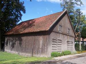 There is a single-storey granary situated on the south side
of the yard. It has a half-timbered, vertically boarded structure,
double-pitched roof, and two gates on the east side. There is a single-storey granary situated on the south side
of the yard. It has a half-timbered, vertically boarded structure,
double-pitched roof, and two gates on the east side.
 No. 28 is a
house from a Dutch homestead of the angular type situated in the southern
section of the village, on the western side of the road, facing it with
its gable. It was erected in the 1st quarter of the 19th century on the
stone-brick foundation and has a log structure with quoins covered by
boards imitating rustication, a vertically boarded gable, a high, double
pitched roof covered by sheet metal, and an original interior layout with
the large room in the southeastern corner and a black kitchen in the large
room bay. The eastern gable elevation has 3 axes, a 2-level gable with 5
axes in the bottom - 3 windows enclosed by skylights topped by reverse
ogee arches and a single window above with similar arches. The southern
elevation has 6 axes with an entrance in the 3rd axis from the
west. No. 28 is a
house from a Dutch homestead of the angular type situated in the southern
section of the village, on the western side of the road, facing it with
its gable. It was erected in the 1st quarter of the 19th century on the
stone-brick foundation and has a log structure with quoins covered by
boards imitating rustication, a vertically boarded gable, a high, double
pitched roof covered by sheet metal, and an original interior layout with
the large room in the southeastern corner and a black kitchen in the large
room bay. The eastern gable elevation has 3 axes, a 2-level gable with 5
axes in the bottom - 3 windows enclosed by skylights topped by reverse
ogee arches and a single window above with similar arches. The southern
elevation has 6 axes with an entrance in the 3rd axis from the
west.
 A building without a number is a Dutch homestead of the
longitudinal type (originally, probably the cross-shaped layout) situated
at the southern end of the village, on the western side of the road,
facing it with its gable. The building is separated from the road by a
small, well-kept park. The house dates from the 3rd quarter of the 19th
century. It has a log structure with covered quoins, a low pointing sill,
a vertically boarded gable, a high, ceramic roof, and a wooden porch
located in front of the gable entrance. The residential section is located
on the eastern side. It has a stylish hallway, which separates the rooms.
The western section is separated from the rest by a black kitchen and a
utility hallway. The eastern elevation has 5 axes, a centrally located
entrance with a porch, and a 2-level gable with 4 axes in the lower level
- two windows enclosed by skylights bound by triangular shapes and a
doubled form of the skylight above. The finial is decorated with fretwork.
The southern elevation has 7 axes with an entrance in the 3rd axis from
the west. A building without a number is a Dutch homestead of the
longitudinal type (originally, probably the cross-shaped layout) situated
at the southern end of the village, on the western side of the road,
facing it with its gable. The building is separated from the road by a
small, well-kept park. The house dates from the 3rd quarter of the 19th
century. It has a log structure with covered quoins, a low pointing sill,
a vertically boarded gable, a high, ceramic roof, and a wooden porch
located in front of the gable entrance. The residential section is located
on the eastern side. It has a stylish hallway, which separates the rooms.
The western section is separated from the rest by a black kitchen and a
utility hallway. The eastern elevation has 5 axes, a centrally located
entrance with a porch, and a 2-level gable with 4 axes in the lower level
- two windows enclosed by skylights bound by triangular shapes and a
doubled form of the skylight above. The finial is decorated with fretwork.
The southern elevation has 7 axes with an entrance in the 3rd axis from
the west.
There is a wooden, half-timbered, boarded granary in
th northeastern section of the yard. It used to be connected to a
livestock building.
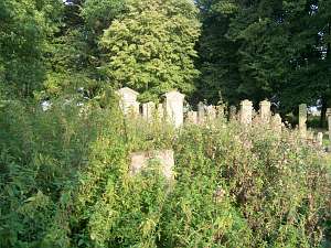 The Mennonite cemetery is situated in the
eastern section of the village, on a rectangular plot divided into 6
sections by one longitudinal and two crosswise alleys. There are several
dozen gravestones in the cemetery, including stone and iron cast crosses,
stalls, and cippuses. A wooden stall of Jacob Entz from 1811 mentioned by
Schmid has not survived. A stone stall of Peter Töws from 1829 is the
oldest gravestone. The Mennonite cemetery is situated in the
eastern section of the village, on a rectangular plot divided into 6
sections by one longitudinal and two crosswise alleys. There are several
dozen gravestones in the cemetery, including stone and iron cast crosses,
stalls, and cippuses. A wooden stall of Jacob Entz from 1811 mentioned by
Schmid has not survived. A stone stall of Peter Töws from 1829 is the
oldest gravestone.
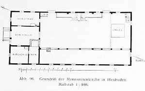 Until 1950, the village had a Mennonite church
from 1768. It had a log structure with quoins covered by boards imitating
rustication, half-timbered, vertically boarded gables, a suspended roof
structure, and a pantile roofing. The church was erected on an elongated
rectangle layout with galleries and an apartment under the southern
gallery. The western elevation had 8 axes, a double-leafed doors and small
windows above, in the 4th and 6th axes from the north. The building had 3
large windows located between doors and low windows (in two levels) in the
1st, 7th, and 8th axes. The southern elevation had 4 axes at a lower
level, an entrance in the 2nd axis from the west, 2 windows above, and 2
windows in the finial. The eastern elevation had 9 axes and 2 levels. Until 1950, the village had a Mennonite church
from 1768. It had a log structure with quoins covered by boards imitating
rustication, half-timbered, vertically boarded gables, a suspended roof
structure, and a pantile roofing. The church was erected on an elongated
rectangle layout with galleries and an apartment under the southern
gallery. The western elevation had 8 axes, a double-leafed doors and small
windows above, in the 4th and 6th axes from the north. The building had 3
large windows located between doors and low windows (in two levels) in the
1st, 7th, and 8th axes. The southern elevation had 4 axes at a lower
level, an entrance in the 2nd axis from the west, 2 windows above, and 2
windows in the finial. The eastern elevation had 9 axes and 2 levels.
SGKP, t.III, s. 49; Schmid, s. 67 - 69; ML II, s. 306-312, Penner, s 73 - 74; s.86; Lipińska, t.III, poz. 115;AG, Warchoł.
|
)