|
gm. Gronowo Elbląskie, pow. elbląski, woj. warmińsko - mazurskie
Until 1945 Aschbuden TK (Endersch Schrötter)
In the Teutonic Knights' period, the area of the later village of Szopy belonged to the Teutonic Knights. In the 1580s the town council divided the area by the lake Drużno into 8 single-włóka plots. In 1586, Karczowiska Górne was founded on 6 plots, while Szopy with the remaining 2 włókas was settled by Dutch colonists. The sources from 1776 mention the following surnames: Goertz, Martens, and Unger. The sources from 1811 mention 3 Mennonites. In the 2nd half of the 19th century, the village had 309 ha, and 197 residents and in 1919 - 312 ha and 290 residents. Village layout - a flood bank linear village located on the western bank of the Fiszefka river. The cultural landscape has been partially destroyed in the northern section of the village by the construction of the Elbląg - Malbork highway, which cut off one farm and the old Fiszewka river crossing with a drawbridge from the beginning of the 20th century. In 1980s, almost all historical buildings were still standing (12 homesteads), but since then, their number has decreased. In the flood bank section, there are 9 longitudinal and 1 angular homesteads. The area along the flood bank overgrew with self-sown trees, but a large part of vegetation around homesteads has survived. The buildings on terpy, in the western section of the village have been demolished. A system of draining canals and polders is still detectable.
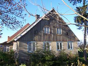 No. 16 is a Dutch homestead of the longitudinal type situated
on the western side of the flood bank, facing it with its gable. A cowshed
is separated from the main building with a high fire wall. The house was
erected in the 1st quarter of the 19th century and modified in 1883. The
building has a stone foundation, a plastered log structure, a boarded
gable, and a queen post - purlin roof structure. The interior has a
1.5-bay layout with the large room in the northeastern corner, a black
kitchen in the large room bay, and 2 separate hallways. The stylish
hallway is located on the south side (not by the large room). There
is a summer room separated from utility rooms on the western side of the
hallway by a corridor. The gable elevation has 4 axes and a 2-level gable
with 4 axes at the bottom, two windows enclosed by quarter circular
skylights, and a semicircular skylight above. The frontal elevation has 5
axes and an entrance with a porch in the 2nd axis from the west. The
cowshed has been transformed and a barn - demolished. No. 16 is a Dutch homestead of the longitudinal type situated
on the western side of the flood bank, facing it with its gable. A cowshed
is separated from the main building with a high fire wall. The house was
erected in the 1st quarter of the 19th century and modified in 1883. The
building has a stone foundation, a plastered log structure, a boarded
gable, and a queen post - purlin roof structure. The interior has a
1.5-bay layout with the large room in the northeastern corner, a black
kitchen in the large room bay, and 2 separate hallways. The stylish
hallway is located on the south side (not by the large room). There
is a summer room separated from utility rooms on the western side of the
hallway by a corridor. The gable elevation has 4 axes and a 2-level gable
with 4 axes at the bottom, two windows enclosed by quarter circular
skylights, and a semicircular skylight above. The frontal elevation has 5
axes and an entrance with a porch in the 2nd axis from the west. The
cowshed has been transformed and a barn - demolished.
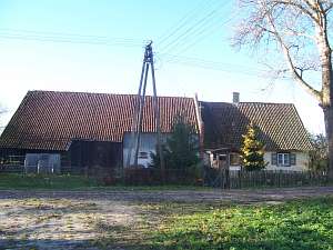
 No. 17 is a
longitudinal Dutch homestead situated on the western side of the flood
bank, facing it with its ridge. A cowshed is slightly higher and is
separated from the main building by a high fire wall. The house dates from
1824 and until 1945 belonged to the Tissen family. It has a brick
underpinning, a plastered log structure with quoins covered by boards
imitating Tuscan pilaster, a boarded gable and attic room, and a queen
post - purlin, two-collar beam roof structure. The interior has a 2-bay
layout with the large room in the northwestern corner and a black kitchen
in the large room bay. The southern section of the house has been
transformed. There is a utility hallway with an entrance to the cowshed
and a staircase to an attic. A black kitchen is located on the yard side
(open to the hallway). The gable elevation has 2 axes and a 2-level gable
with 3 axes in the lower level, a window enclosed by 2 quarter circular
skylights, and a semicircular skylight above. The frontal elevation has 4
axes and an entrance (with a porch) in the 2nd axis from the west. The
cowshed was transformed at the end of the 19th century. It has 1.5
stories, a brick structure at the lower level and a wooden post structure
at the upper level. The barn has a single threshing floor and a mow with
two cubbyholes. No. 17 is a
longitudinal Dutch homestead situated on the western side of the flood
bank, facing it with its ridge. A cowshed is slightly higher and is
separated from the main building by a high fire wall. The house dates from
1824 and until 1945 belonged to the Tissen family. It has a brick
underpinning, a plastered log structure with quoins covered by boards
imitating Tuscan pilaster, a boarded gable and attic room, and a queen
post - purlin, two-collar beam roof structure. The interior has a 2-bay
layout with the large room in the northwestern corner and a black kitchen
in the large room bay. The southern section of the house has been
transformed. There is a utility hallway with an entrance to the cowshed
and a staircase to an attic. A black kitchen is located on the yard side
(open to the hallway). The gable elevation has 2 axes and a 2-level gable
with 3 axes in the lower level, a window enclosed by 2 quarter circular
skylights, and a semicircular skylight above. The frontal elevation has 4
axes and an entrance (with a porch) in the 2nd axis from the west. The
cowshed was transformed at the end of the 19th century. It has 1.5
stories, a brick structure at the lower level and a wooden post structure
at the upper level. The barn has a single threshing floor and a mow with
two cubbyholes.
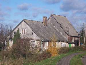 No. 15 is a longitudinal Dutch homestead situated
on the western side of the flood bank, facing it with its ridge. A cowshed
is much higher than the rest of the homestead. The house was erected in
the 1st quarter of the 19th century. The roof was lowered probably after
1945. The building has a plastered log structure and a boarded gable. The
gable elevation has 3 axes with a new, 3-axial gable. The frontal
elevation has 5 axes with an entrance and a modern porch in the 2nd axis
from the north. The cowshed has partially brick (bottom) and partially
wooden, post, vertically boarded structure. The size of the barn has been
reduced, and currently, it has a single threshing floor. No. 15 is a longitudinal Dutch homestead situated
on the western side of the flood bank, facing it with its ridge. A cowshed
is much higher than the rest of the homestead. The house was erected in
the 1st quarter of the 19th century. The roof was lowered probably after
1945. The building has a plastered log structure and a boarded gable. The
gable elevation has 3 axes with a new, 3-axial gable. The frontal
elevation has 5 axes with an entrance and a modern porch in the 2nd axis
from the north. The cowshed has partially brick (bottom) and partially
wooden, post, vertically boarded structure. The size of the barn has been
reduced, and currently, it has a single threshing floor.

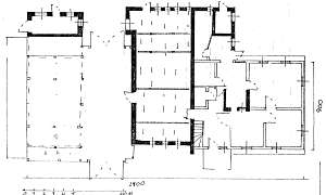
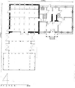 No. 12
is a Dutch homestead of the angular type situated on the western side of
the flood bank, facing it with a gable. The ridge of the entire homestead
is of the same height. A cowshed is separated from the rest by a fire
wall. The house was erected in the 1st quarter of the 19th century and
modified in 1883. It has a brick foundation, a plastered log structure, a
boarded gable, a log extension (supported by 4 posts) with corners covered
by boards carved into Parthian arch, a queen post - purlin roof structure,
and asbestos tile roofing. The interior has a 2-bay layout with a wider
southern bay, the large room in the southeastern corner, a centrally
located black kitchen, and a bipartite, L-shaped hallway, which separates
a summer room and utility rooms on the western side of the hallway. The
gable elevation has 2 axes and a 2-axial gable. The frontal elevation has
6 axes, an entrance between 2 half-windows (in the 3rd axis), and a
shallow arcade. The cowshed (square-like layout) was transformed at the
beginning of the 20th century. A perpendicular barn has two threshing
floors and a wide mow with two cubbyholes. No. 12
is a Dutch homestead of the angular type situated on the western side of
the flood bank, facing it with a gable. The ridge of the entire homestead
is of the same height. A cowshed is separated from the rest by a fire
wall. The house was erected in the 1st quarter of the 19th century and
modified in 1883. It has a brick foundation, a plastered log structure, a
boarded gable, a log extension (supported by 4 posts) with corners covered
by boards carved into Parthian arch, a queen post - purlin roof structure,
and asbestos tile roofing. The interior has a 2-bay layout with a wider
southern bay, the large room in the southeastern corner, a centrally
located black kitchen, and a bipartite, L-shaped hallway, which separates
a summer room and utility rooms on the western side of the hallway. The
gable elevation has 2 axes and a 2-axial gable. The frontal elevation has
6 axes, an entrance between 2 half-windows (in the 3rd axis), and a
shallow arcade. The cowshed (square-like layout) was transformed at the
beginning of the 20th century. A perpendicular barn has two threshing
floors and a wide mow with two cubbyholes.
SGKP, t.I, s. 50; Kerstan, s.136-137, Piątkowski, s.23, Mamuszka, s.114; Lipińska, t.III, poz.94; AG IV, BF.
|
)