|
gm. Sztutowo, pow. nowodworski, woj. pomorskie
Until 1945 Stutthoff (Endersch, Schrötter
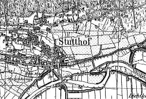
In the Middle Ages, the southern section of the Sztutowo region was covered by the Vistula Lagoon, while the village area itself was owned by Pomeranian dukes. Based on a treaty from 1282, the area was transferred to the Teutonic Order. After 1466, the terrain, including the Mierzeja was taken over by the city of Gdańsk. The village with an inn and a manor was established at that time. Hauptmann von Stuthow - the administrator (on behalf of the Gdańsk town council) of the surrounding estate - resided in the Sztutowo manor. At the beginning of the, 17th century, the village had 23 włókas of ploughland and ca. 13 homesteads. Following the Swedish occupation of 1629 - 1635, Gdańsk relinquished the administration of the Sztutowo region and leased the estate. The manor and village were destroyed in 1734 by Russian soldiers. In 1820, the village had 1209 residents, including 4 Mennonites (1 - in the manor). The sources from 1929 mentioned the following land owners Heinrich Funk, Artur Foth, Oto Froese, Johann Peters, and in 1922 also - Otto Dueck and Paul Foth. In 1936, the village had 42 Mennonites (15 - still un-baptized) with the surnames Claassen, Epp, Heidebrecht, Penner, Peters, Thiesen, Wiebe, Wiens, and Willemp. Village layout - the village consists of two sections: the proper village and the manor; originally, it was a linear village situated on the northern side of the road to Gdańsk, but beginning in the mid 19th century the village was expanded westward and along a new parallel road in the northern section, which was separated at the beginning of the 20th century by a narrow-gauge railway. The village underwent a further development associated with its health resort function. New buildings were constructed along other parallel streets. The manor is located in the eastern section of the village. The cultural landscape dates mostly from the end of the 19th century, when the settlement began to function as a resort. Wooden and masonry buildings that were built at the time line Gdańska street. The spatial layout of the village was affected by localization of a concentration camp - northwestern section. After 1945, the village underwent another period of intensified development - modern buildings (tourist accommodation) of unremarkable architecture, unrelated to the region and landscape. Some of the old buildings have been replaced. The estate has been devastated and transformed. A draw bridge, some wooden and brick houses from the beginning of the 20th century, a school, and several layouts of Dutch homesteads have survived.
A building at Obozowa 4 is a longitudinal Dutch homestead from the 1st quarter of the 20th century with a cowshed (almost the same ridge height) separated from the house by a fire wall. The homestead is situated on the southern side of the Obozowa st., facing it with its ridge. The building is made of white brick with red brick decorations - corners, cornices, and window surrounds.
ML, t. IV, s. 268, AG IV, Lipińska, t.III, poz. 268.
|
)